geocat.ch
VECTOR25 Primary surfaces
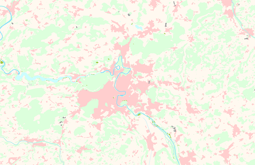
The layer primary surfaces (abbreviation "pri") describes the soil coverage. The types of surfaces are mutually exclusive (lake and forest) and form an explicit and complete area network. As opposed to the National Map, the primary surfaces contain interpreted inhabited areas. Buildings are shown in a separate layer. The linear objects of this layer form the boundaries between the surfaces. They are an individual kind of object which can generally not be deducted from the surface ("river bank left" - "river bank right", "defined forest outline" - "undefined forest outline").
Simple
- Alternate title
-
Primary surfaces VECTOR25
- Date (Publication)
- 2008-08-31
- Identifier
- ch.swisstopo.vec25-primaerflaechen
- Other citation details
-
Part of the vECTOR25 Dataset
- Status
- Completed
Point of contact
- Spatial representation type
- Vector
Spatial resolution
Equivalent scale
- Denominator
- 25000
- Topic category
-
- A Imagery base maps earth cover
Extent
Extent
- Description
-
National Map 1:25'000
- Geographic identifier
- NM25
))

- Maintenance and update frequency
- Not planned
- Hierarchy level
- Dataset
- Maintenance note
-
Since 2008 not updated anymore
Resource format
- Title
-
ESRI ArcInfo coverage (COV)
- Date
- GEMET
-
-
human settlement
-
wood
-
vegetation
-
geographic information system
-
- GEMET - INSPIRE themes, version 1.0
-
-
Land cover
-
- geocat.ch
-
-
primary surface
-
e-geo.ch
-
GIS (Geographic Information System)
-
landscape model
-
- geocat.ch
-
-
FSDI Federal Spatial Data Infrastructure
-
Resource constraints
- Use constraints
- License
Associated resource
- Association Type
- Reference to a master resource of which this one is a part
- Metadata Reference
Associated resource
- Title
-
VECTOR25 pri
- Association Type
- Reference to a master resource of which this one is a part
- Language
- Deutsch
- Character encoding
- UTF8
- Language
- English
- Character encoding
- UTF8
- Environment description
-
ARC/INFO
- Supplemental Information
-
The layers Road network, Railway network, Other traffic, Hydrographic network, Primary surfaces, Buildings, Hedges and trees, Functional surfaces and Single objects build together the dataset VECTOR25.
- Subtopic Category
- A1 Base Maps, Landscape Models
- Compliance code
- 0
- Language
- Deutsch
- Language
- Français
- Included with dataset
- 0
- Title
-
VECTOR25 Das digitale Lanschaftsmodell der Schweiz : Produkteinformation
- Date (Publication)
- 2007-06-01
- Presentation form
- Digital document
- Distribution format
-
-
AutoCAD DXF (DXF)
-
ESRI Shapefile (SHP)
-
Digital transfer options
- OnLine resource
-
Vorschau map.geo.admin.ch
Preview map.geo.admin.ch
Digital transfer options
- OnLine resource
-
ch.swisstopo.vec25-primaerflaechen
WMS-FSDI service, layer "Primary surfaces VECTOR25"
Digital transfer options
- OnLine resource
-
ch.swisstopo.vec25-primaerflaechen
WMTS-FSDI service, layer "Primary surfaces VECTOR25"
Digital transfer options
Digital transfer options
- OnLine resource
-
RESTful API von geo.admin.ch
RESTful API from geo.admin.ch
- Statement
-
Content and geometry based on the swiss National Map 1:25'000. Geometric precision : 3-8 m.
- Hierarchy level
- Dataset
- Topology level
- Full planar graph
- Geometric object type
- Surface
- Geometric object count
- 690000
- Geometric object type
- Curve
- Geometric object count
- 1330000
- Reference system identifier
- Content and geometry based on the swiss National Map 1:25'000. Geometric precision : 3-8 m.
- Maintenance and update frequency
- As needed
Metadata
- Metadata identifier
- fb4c7281-bd58-4aae-b86a-3a73ba82e0aa
- Language
- Deutsch
- Character encoding
- UTF8
- Language
- Français
- Character encoding
- UTF8
- Language
- Italiano
- Character encoding
- UTF8
- Language
- English
- Character encoding
- UTF8
- Language
- Rumantsch
- Character encoding
- UTF8
Point of contact
Type of resource
- Resource scope
- Dataset
- Name
-
Layer
- Metadata linkage
-
https://www.geocat.ch/geonetwork/srv/api/records/fb4c7281-bd58-4aae-b86a-3a73ba82e0aa
- Date info (Creation)
- 2007-12-17T12:00:00Z
- Date info (Revision)
- 2026-04-13T09:17:41.399639Z
Metadata standard
- Title
-
eCH-0271