geocat.ch
VECTOR25
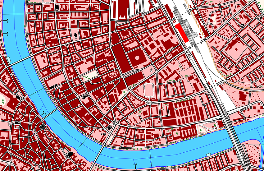
VECTOR25 is a digital lanscape model of Switzerland. The content and geometry are based on the National Map 1:25'000. VECTOR25 reproduces mandmade and natural features in a flexible vector format VECTOR25 represents about 8.5 millions features with their position, shape, features type, descriptive attributes and relationship with others features (topology). VECTOR25 consists in 9 thematic layers : Road network, Railway network, Other traffic, Hydrographic network, Primary surfaces, Buildings, Hedges and trees, Functional surfaces and Single objects.
Simple
- Date (Last Revision)
- 2008-08-31
- Date (Creation)
- 1995-01-01T00:00:00
- Status
- Completed
Point of contact
Owner
- Spatial representation type
- Vector
Spatial resolution
Equivalent scale
- Denominator
- 25000
- Topic category
-
- A Imagery base maps earth cover
Extent
Extent
- Description
-
National Map 1:25'000
- Geographic identifier
- NM25
))

- Maintenance and update frequency
- Annually
- Duration of Conservation
- 275
- Appraisal of Archival Value
- A
- Reason for Archiving Value
- Evidence of business practice
- geocat.ch
-
-
landscape model
-
traffic network
-
GIS (Geographic Information System)
-
primary surface
-
Conservation and archiving planning AAP - Confederation
-
official geodata
-
- GEMET
-
-
geographic information system
-
road network
-
railway network
-
hedge
-
Associated resource
- Title
-
Topografisches Landschaftsmodell (Landesvermessung)
- Association Type
- Reference to a master resource of which this one is a part
- Language
- Deutsch
- Character encoding
- UTF8
- Language
- English
- Character encoding
- UTF8
- Subtopic Category
- A1 Base Maps, Landscape Models
- Distribution format
-
-
AutoCAD DXF (DXF)
-
ESRI Shapefile (SHP)
-
- Statement
-
Content and geometry based on the swiss National Map 1:25'000. Geometric precision: 3-8 m.
- Hierarchy level
- Dataset
- Topology level
- Topology 1D
- Geometric object type
- Surface
- Geometric object count
- 2926950
- Geometric object type
- Curve
- Geometric object count
- 5770999
- Geometric object type
- Point
- Geometric object count
- 2872073
- Reference system identifier
- EPSG:21781
Metadata
- Metadata identifier
- aee4fe79-a583-46a1-bf46-19ee613ce415
- Language
- Deutsch
- Character encoding
- UTF8
- Language
- Français
- Character encoding
- UTF8
- Language
- Italiano
- Character encoding
- UTF8
- Language
- English
- Character encoding
- UTF8
Point of contact
Type of resource
- Resource scope
- Dataset
- Metadata linkage
-
https://www.geocat.ch/geonetwork/srv/api/records/aee4fe79-a583-46a1-bf46-19ee613ce415
- Date info (Creation)
- 2007-12-17T12:00:00Z
- Date info (Revision)
- 2026-04-13T09:30:10.971414Z
Metadata standard
- Title
-
GM03 2+