geocat.ch
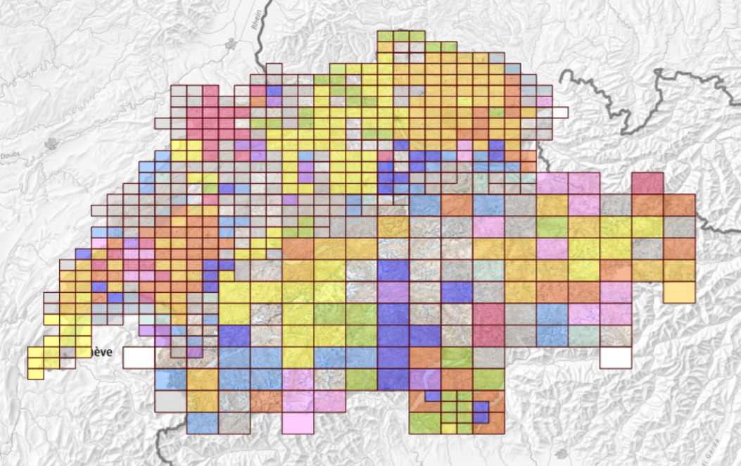
Sheet Division of the Siegfried Map
The Topographische Atlas der Schweiz (Siegfried map) was published over the period from 1870 to 1926 with revisions up to 1939. It was published at 1:25 000 scale for the lowland areas of the Mittelland, the Jura and south Ticino, and at 1:50 000 scale for alpine regions. The dataset "Sheet Division of the Siegfried Map" shows the perimeter, number and name of each sheet of the map. With the historical data visualization tool – called “Journey through Time” – all editions of the map can be viewed interactively, also using the layer “Topographic Atlas of Switzerland (Siegfried Map)”.
Simple
- Alternate title
-
Division Siegfried Map 25/50 Raster
- Date (Publication)
- 1870-12-31
- Identifier
- ch.swisstopo.hiks-siegfried.metadata
Owner
Spatial resolution
Equivalent scale
- Denominator
- 25000
- Topic category
-
- A Imagery base maps earth cover
Extent
Extent
- Description
-
Geographical extend Siegfried map 1:50000
- Geographic identifier
- Siegfried 1:50000
))

Extent
Extent
- Description
-
Etendue géographique carte Siegfried 1:25000
- Geographic identifier
- Etendue géographique carte Siegfried 1:25000
))

- Maintenance and update frequency
- Unknown
- geocat.ch
-
-
FSDI Federal Spatial Data Infrastructure
-
Resource constraints
- Use constraints
- Other restrictions
Associated resource
- Association Type
- Resource is a description of associated resource
- Metadata Reference
Associated resource
- Title
-
Historical maps
- Association Type
- Reference to a master resource of which this one is a part
- Language
- Deutsch
- Character encoding
- UTF8
- Subtopic Category
- A1 Base Maps, Landscape Models
- Basic Geodata
- true
- Basic Geodata ID
-
49.1
- Basic Geodata Legal Level
- Federal
- Distribution format
-
-
ESRI Shapefile (SHP)
-
Digital transfer options
- OnLine resource
-
Vorschau map.geo.admin.ch
Preview map.geo.admin.ch
Digital transfer options
- OnLine resource
-
ch.swisstopo.hiks-siegfried.metadata
WMS-FSDI service, layer "Division Siegfried Map 25/50 Raster"
Digital transfer options
- OnLine resource
-
RESTful API von geo.admin.ch
RESTful API from geo.admin.ch
- Geometric object type
- Surface
- Reference system identifier
- EPSG:21781
Metadata
- Metadata identifier
- e986a2d2-aeae-4b3c-87e5-bef9c62c58c8
- Language
- Deutsch
- Character encoding
- UTF8
- Language
- Français
- Character encoding
- UTF8
- Language
- Italiano
- Character encoding
- UTF8
- Language
- English
- Character encoding
- UTF8
- Language
- Rumantsch
- Character encoding
- UTF8
Custodian
Type of resource
- Resource scope
- Dataset
- Metadata linkage
-
https://www.geocat.ch/geonetwork/srv/api/records/e986a2d2-aeae-4b3c-87e5-bef9c62c58c8
- Date info (Creation)
- 2025-09-02T09:26:47.529Z
- Date info (Revision)
- 2026-05-27T10:16:07.733999Z
Metadata standard
- Title
-
eCH-0271