geocat.ch
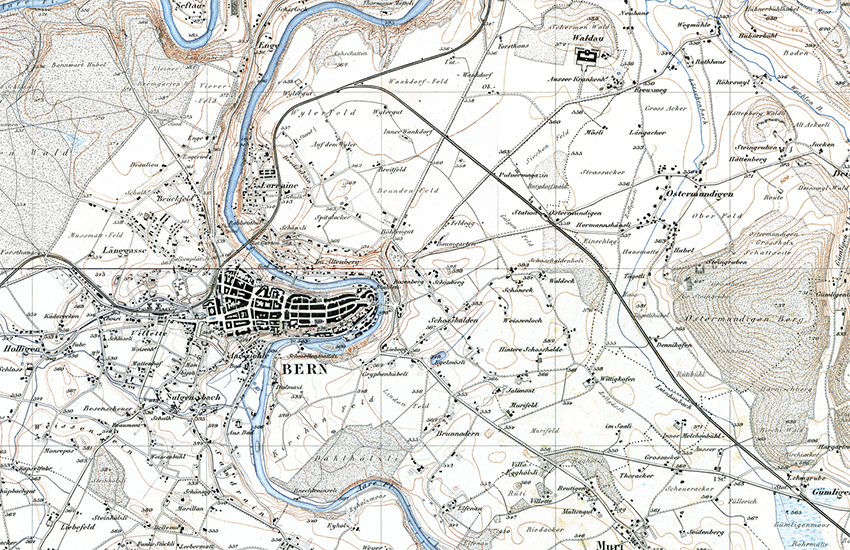
Topographic Atlas of Switzerland (Siegfried Map)
The Topographic Atlas of Switzerland was published between 1870 and 1926, initially under the direction of Colonel Hermann Siegfried. It was the first detailed overall map of Switzerland, at a scale of 1:25,000 for the Central Plateau, the Jura, and southern Ticino, and at a scale of 1:50,000 for the Alps. In total, taking into account the periodic updates carried out until 1949, more than 4,000 revised sheets were published. Two different techniques were used for the initial production: copper engraving for the 462 sheets at 1:25,000 and lithography for the 142 sheets at 1:50,000. With the historical data visualization tool – called “Journey through Time” – all editions of the map can be viewed interactively, also with the layer "Division Siegfried Map 25/50 Raster".
Simple
- Alternate title
-
Siegfried Map
- Date (Creation)
- 1870-01-01T00:00:00
- Date (Last Revision)
- 1949-01-01T00:00:00
- Identifier
- ch.swisstopo.hiks-siegfried
- Presentation form
- Digital map
- Presentation form
- Hardcopy map
- Purpose
-
Georeferenzdaten
- Status
- Historical archive
- Status
- Completed
Owner
Point of contact
- Spatial representation type
- Grid
Spatial resolution
Equivalent scale
- Denominator
- 25000
Spatial resolution
Equivalent scale
- Denominator
- 50000
- Topic category
-
- A Imagery base maps earth cover
Extent
Extent
- Description
-
Siegfried map
- Geographic identifier
- TA
))

- Maintenance and update frequency
- Not planned
- Duration of Conservation
- 275
- Appraisal of Archival Value
- A
- Reason for Archiving Value
- Evidence of business practice
Resource format
- Title
-
Tagged Image File Format (TIFF)
- Date
- geocat.ch
-
-
national border
-
path
-
official geodata
-
GIS (Geographic Information System)
-
contour line
-
spot height
-
individual Symbol
-
terrain representation
-
historic map
-
Conservation and archiving planning AAP - Confederation
-
national map
-
river
-
e-geo.ch
-
- GEMET
-
-
cartography
-
nomenclature
-
province
-
highway
-
rock
-
brook
-
water (geographic)
-
- geocat.ch
-
-
FSDI Federal Spatial Data Infrastructure
-
- GEMET
-
-
mountain
-
- geocat.ch
-
-
topography
-
- GEMET
-
-
map chart
-
Associated resource
- Title
-
Historische Karten
- Association Type
- Reference to a master resource of which this one is a part
- Language
- Deutsch
- Character encoding
- UTF8
- Language
- Français
- Character encoding
- UTF8
- Language
- Italiano
- Character encoding
- UTF8
- Subtopic Category
- A1 Base Maps, Landscape Models
- Basic Geodata
- true
- Basic Geodata ID
-
49.1
- Basic Geodata Legal Level
- Federal
- Basic Geodata Type
- Reference Geodata
- Attribute description
- RGB-Werte
- Distribution format
-
-
JPEG (JPG)
-
Tagged Image File Format (TIFF)
-
Digital transfer options
- OnLine resource
-
Vorschau map.geo.admin.ch
Preview map.geo.admin.ch
Digital transfer options
- OnLine resource
-
ch.swisstopo.hiks-siegfried
WMS-FSDI service, layer "Siegfried Map First edition"
Digital transfer options
- OnLine resource
-
ch.swisstopo.hiks-siegfried
WMTS-FSDI service, layer "Siegfried Map First edition"
Digital transfer options
- OnLine resource
-
RESTful API von geo.admin.ch
RESTful API from geo.admin.ch
- Statement
-
Based on the Siegfried Map 1:25 000 and 1:50 000
- Hierarchy level
- Dataset
- Number of dimensions
- 2
- Dimension name
- Column
- Dimension size
- 7000
- Resolution
- 508 m
- Dimension name
- Row
- Dimension size
- 4800
- Resolution
- 508 m
- Cell geometry
- Area
- Transformation parameter availability
- 0
Metadata
- Metadata identifier
- d3b21424-70a4-4984-a693-aa7f11813c53
- Language
- Deutsch
- Character encoding
- UTF8
- Language
- Français
- Character encoding
- UTF8
- Language
- Italiano
- Character encoding
- UTF8
- Language
- English
- Character encoding
- UTF8
- Language
- Rumantsch
- Character encoding
- UTF8
Custodian
Type of resource
- Resource scope
- Dataset
- Metadata linkage
-
https://www.geocat.ch/geonetwork/srv/api/records/d3b21424-70a4-4984-a693-aa7f11813c53
- Date info (Creation)
- 2008-11-11T12:00:00Z
- Date info (Revision)
- 2026-04-13T09:23:04.805178Z
Metadata standard
- Title
-
GM03 2+