geocat.ch
Hangneigungsklassen ab 30 Grad
Classes de pente de plus de 30 degrés
Classi di pendenza maggiori di 30 gradi
Slope classes over 30 degrees
Classas da pendenza da dapli che 30 grads
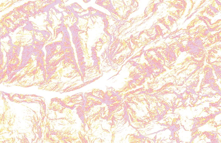
Derivat aus dem digitalen Höhenmodell swissALTI3D und aus den Modellen von Frankreich, Italien, Österreich und Deutschland welches die Identifikation von Hangneigungen von 30° und mehr erlaubt. Diese Information ist bei der Unfall- und Lawinenprävention hilfreich. Die Hangneigungen über 30° sind gemäss der Empfehlung vom Institut für Schnee- und Lawinenforschung SLF in 4 Klassen kategorisiert. Sie wurden aus einem kombinierten digitalen Höhenmodell bestehend aus swissALTI3D für die Schweiz und Liechtenstein, RGE ALTI für Frankreich, TINITALY/01 für Italien, DGM10 für Österreich, DGM1 für Bayern und EU-DEM für Baden-Württemberg und mit einer Auflösung von 10m abgeleitet. Im Übergangsbereich zwischen den zwei Basismodellen kann die Genauigkeit der Hangneigungswerte nicht garantiert werden. Haftungsansprüche aufgrund der Darstellung der Hangneigungen können nicht geltend gemacht werden.
Représentation dérivée du modèle altimétrique numérique swissALTI3D et ceux de France, d’Italie, d’Autriche et d’Allemagne qui permet d'identifier les pentes de plus de 30°. Cette information est utile à la prévention des accidents d'avalanche. Les pentes de plus de 30° sont classées en 4 catégories selon les recommandations de l'institut pour l'étude de la neige et des avalanches SLF. La pente représente la première dérivée d'un modèle altimétrique numérique. Elle a été calculée sur un modèle altimétrique numérique avec une résolution de 10m combinant swissALTI3D pour la Suisse et le Liechtenstein, RGE ALTI pour la France, TINITALY/01 pour l’Italie, DGM10 pour l’Autriche, DGM1 pour la Bavière et EU-DEM pour le Bade-Wurtemberg. Au passage entre les deux modèles de base, l'exactitude des valeurs de pente n'est pas garantie. Toute responsabilité basée sur la représentation des pentes de plus de 30° est exclue.
Rappresentazione derivata dai modelli altimetrici digitali swissALTI3D e quelli (i rispettivi) della Francia, dell’Italia, dell’Austria e della Germania, che permette l’identificazione delle pendenze dei versanti superiori a 30°. Questa informazione è utile nell’ambito della prevenzione degli incidenti causati da valanghe. Le pendenze superiori a 30° sono classificate in 4 categorie secondo l’Istituto per lo studio della neve e delle valanghe SLF. Essa è stata calcolata a partire da un modello altimetrico digitale con una risoluzione di 10m, costituito da swissALTI3D per la Svizzera e il Liechtenstein, RGE ALTI per la Francia, TINITALY/01 per l’Italia, DGM10 per l’Austria, DGM1 per la Baviera e EU-DEM per il Baden-Württemberg. Nella zona transitoria tra i due modelli di base, la precisione dei valori delle pendenze non è garantita. È esclusa qualsiasi richiesta di responsabilità basata sulla rappresentazione delle pendenze superiori a 30°.
Derivate representation of the digital terrain model swissALTI3D and models from France, Italy, Austria and Germany, which allows for the identification of inclinations over 30°. According to the recommendation of the Institute for Snow and Avalanche Research SLF the slopes are categorized into 4 classes. They were calculated from a combined digital terrain with a resolution of 10m made up from swissALTI3D for Switzerland and Liechtenstein, RGE ALTI for France, TINITALY for Italy, DGM10 for Austria, DGM1 for Bavaria and EU-DEM for Baden-Württemberg. The precision of the inclination values in the transistional area between the different base models cannot be guaranteed. Liability claims for the representation of gradients over 30° cannot be asserted.
In derivat dals models digital da l'autezza swissALTI3D e quels dalla Frantscha, dall’Italia, dall’Austria e dalla Germania che permetta d'identifitgar pendenzas da la spunda da 30° e dapli. Questa infurmaziun gida en connex cun la prevenziun d'accidents e da lavinas. Las pendenzas da la spunda da passa 30° ha tenor la recumandaziun da l'Institut per la perscrutaziun da naiv e lavinas SLF categorias en 4 classas. Ellas èn vegnidas deducidas d'in model digital da l'autezza cumbinà che consista da swissALTI3D per la Svizra e il Liechtenstein, RGE ALTI per la Frantscha, TINITALY/01 per l’Italia, DGM10 per l’Austria, DGM1 per la Baviera e EU-DEM per il Baden-Württemberg, cun ina dissoluziun da 10 m. En il sectur transitoric tranter ils models da basa na po l'exactadad da las pendenzas da la spunda betg vegnir garantida. Pretensiuns da responsabladad pervia da la preschentaziun da las pendenzas da la spunda na pon betg vegnir fatgas valair.
Simple
-
Autre titreAltri nomi o acronimiAlternate titleAlternate titleAlternativtitel
-
Hangneigungsklassen ab 30°
Classes de pente plus de 30°
Classi pendenza maggiori 30°
Slope classes over 30°
Classas pendenza dapli che 30°
-
Date (Publication)Data (Pubblicazione)Date (Publication)Date (Publication)Datum (Publikation)
- 2016-10-01
-
Date (Révision)Data (Revisione)Date (Revision)Date (Revision)Datum (Aktualisierung)
- 2023-12-05
-
IdentifiantIdentificatoreIdentifierIdentifierKennung
- ch.swisstopo.hangneigung-ueber_30
Point de contact
Punto di contatto
Point of contact
Point of contact
Ansprechpartner
Propriétaire
Proprietario
Owner
Owner
Eigentümer
-
Type de représentation spatialeTipo di rappresentazione spazialeSpatial representation typeSpatial representation typeRäumliche Darstellungsart
-
grilleRasterGridGridRaster, Gitter
Résolution spatiale
Risoluzione spaziale
Spatial resolution
Spatial resolution
Räumliche Auflösung
-
Distance de résolutionDistanza di risoluzioneSpatial resolutionSpatial resolutionDistanz
- 10 m
-
Catégorie de thèmeCategoria ISOTopic categoryTopic categoryThematik
-
-
C ÉlévationC AltitudineC ElevationC ElevationC Höhenangaben
-
Étendue
Estensione
Extent
Extent
Ausdehnung
Étendue
Estensione
Extent
Extent
Ausdehnung
-
DescriptionDescrizioneDescriptionDescriptionBeschreibung
-
swissALTIRegio
swissALTIRegio
swissALTIRegio
swissALTIRegio
))

-
Fréquence de mise à jourFrequenza di aggiornamentoMaintenance and update frequencyMaintenance and update frequencyWartungsintervall
-
AnnuelleAnnualmenteAnnuallyAnnuallyJährlich
-
Remarque sur la mise à jourNota sull'aggiornamentoMaintenance noteMaintenance noteAnmerkung
-
Aus den aktualisierten Daten vom Elterndatensatz swissALTI3D werden die Hangneigungen neu berechnet.
Après la mise à jour du jeu de données parent, les pentes sont calculées à nouveau.
A slope calculation is carried through on the updated parent data set.
- GEMET
-
-
modèle terrestre numérique
modello digitale del territorio
digital land model
-
système d'information géographique
sistema informativo geografico
geographic information system
-
laser
laser (radiazione)
laser
-
- geocat.ch
-
-
SIG (Système d'Information Géographique)
SIG (Sistema Informativo Geografico)
GIS (Geographic Information System)
-
visualisation 3D
visualizzazione 3D
3D visualisation
-
simulation 3D
simulazione 3D
3D simulation
-
LIDAR (Light Detection And Ranging)
LIDAR (Light Detection And Ranging)
LIDAR (Light Detection And Ranging)
-
laserscanning
laserscanning
laserscanning
-
MNA (modèle numérique d'altitude)
DEM (modello digitale di elevazione)
DEM (digital elevation model)
-
opendata.swiss
opendata.swiss
opendata.swiss
opendata.swiss
-
- GEMET - INSPIRE themes, version 1.0
-
-
Altitude
Elevazione
Elevation
-
- geocat.ch
-
-
BGDI Bundesgeodaten-Infrastruktur
IFDG l’Infrastructure Fédérale de données géographiques
IFDG Infrastruttura federale dei dati geografici
FSDI Federal Spatial Data Infrastructure
-
Ressource associée
Risorsa associata
Associated resource
Associated resource
Verlinkte Ressource
-
Type d'associationTipo di associazioneAssociation TypeAssociation TypeAssoziationstyp
-
Citation de travail plus largeCitazione di un'opera più ampiaReference to a master resource of which this one is a partReference to a master resource of which this one is a partÜbergeordneter Datenbestand
-
Metadata ReferenceRiferimento metadatiMetadata ReferenceMetadata ReferenceMetadatenreferenz
Ressource associée
Risorsa associata
Associated resource
Associated resource
Verlinkte Ressource
-
TitreTitoloTitleTitleTitel
-
Höhendaten (Landesvermessung)
Données altimétriques (mensuration nationale)
Dati altimetrici (misurazione nazionale)
-
Type d'associationTipo di associazioneAssociation TypeAssociation TypeAssoziationstyp
-
Citation de travail plus largeCitazione di un'opera più ampiaReference to a master resource of which this one is a partReference to a master resource of which this one is a partÜbergeordneter Datenbestand
-
LangueLinguaLanguageLanguageSprache
- Deutsch
-
Encodage de caractèresCodifica dei caratteriCharacter encodingCharacter encodingZeichenkodierung
-
Utf8UTF8UTF8UTF8Utf8
-
LangueLinguaLanguageLanguageSprache
- English
-
Encodage de caractèresCodifica dei caratteriCharacter encodingCharacter encodingZeichenkodierung
-
Utf8UTF8UTF8UTF8Utf8
-
Géodonnées de baseGeodati di baseBasic GeodataBasic GeodataGeobasisdaten
- true
-
Identifiant Géodonnées de baseIdentificativo dei geodati di baseBasic Geodata IDBasic Geodata IDIdentifikator des Geobasisdatensatzes
-
41.6
-
Niveau des géodonnées de baseLivello legale dei geodati di baseBasic Geodata Legal LevelBasic Geodata Legal LevelGeobasisdatenebene
-
FédéralFederaleFederalFederalNational
-
Format de distributionFormato (codifica)Distribution formatDistribution formatAbgabeformat
-
-
nan
-
Options de transfert numérique
Opzioni di trasferimento digitale
Digital transfer options
Digital transfer options
Optionen für die digitale Übertragung
-
Ressource en ligneRisorsa onlineOnLine resourceOnLine resourceOnline
-
Vorschau map.geo.admin.ch
Vorschau map.geo.admin.chAperçu map.geo.admin.chPrevisione map.geo.admin.chPreview map.geo.admin.ch
Options de transfert numérique
Opzioni di trasferimento digitale
Digital transfer options
Digital transfer options
Optionen für die digitale Übertragung
-
Ressource en ligneRisorsa onlineOnLine resourceOnLine resourceOnline
-
ch.swisstopo.hangneigung-ueber_30
WMS-BGDI Dienst, Layer "Hangneigungsklassen ab 30°"Service WMS-IFDG, couche "Classes de pente plus de 30°"Servizio WMS-IFDG, strato "Classi pendenza maggiori 30°"WMS-FSDI service, layer "Slope classes over 30°"WMS-BGDI Dienst, Layer "Hangneigungsklassen ab 30°"
Options de transfert numérique
Opzioni di trasferimento digitale
Digital transfer options
Digital transfer options
Optionen für die digitale Übertragung
-
Ressource en ligneRisorsa onlineOnLine resourceOnLine resourceOnline
-
ch.swisstopo.hangneigung-ueber_30
WMTS-BGDI Dienst, Layer "Hangneigungsklassen ab 30°"Service WMTS-IFDG, couche , Layer "Classes de pente plus de 30°"Servizio WMTS-IFDG, strato "Classi pendenza maggiori 30°"WMTS-FSDI service, layer "Slope classes over 30°"WMTS-BGDI Dienst, Layer "Hangneigungsklassen ab 30°"
Options de transfert numérique
Opzioni di trasferimento digitale
Digital transfer options
Digital transfer options
Optionen für die digitale Übertragung
-
Ressource en ligneRisorsa onlineOnLine resourceOnLine resourceOnline
-
swissALTI3D
Options de transfert numérique
Opzioni di trasferimento digitale
Digital transfer options
Digital transfer options
Optionen für die digitale Übertragung
-
Ressource en ligneRisorsa onlineOnLine resourceOnLine resourceOnline
-
Französiches Modell RGE ALTI
Options de transfert numérique
Opzioni di trasferimento digitale
Digital transfer options
Digital transfer options
Optionen für die digitale Übertragung
-
Ressource en ligneRisorsa onlineOnLine resourceOnLine resourceOnline
-
Italienisches Modell TINITALY/01
Options de transfert numérique
Opzioni di trasferimento digitale
Digital transfer options
Digital transfer options
Optionen für die digitale Übertragung
-
Ressource en ligneRisorsa onlineOnLine resourceOnLine resourceOnline
-
Österreichisches Modell DGM10
Options de transfert numérique
Opzioni di trasferimento digitale
Digital transfer options
Digital transfer options
Optionen für die digitale Übertragung
-
Ressource en ligneRisorsa onlineOnLine resourceOnLine resourceOnline
-
Bayerisches Modell DGM1
-
Nombre de dimensionsNumero di dimensioniNumber of dimensionsNumber of dimensionsAnzahl der Dimensionen
- 3
-
Géométrie de la celluleGeometria della cellaCell geometryCell geometryZellgeometrie
-
PointPuntoPointPointpoint
-
Disponibilité des paramètres de transformationDisponibilità dei parametri di trasformazioneTransformation parameter availabilityTransformation parameter availabilityVerfügbarkeit der Transformationsparameter
- 1
-
Nom du système de référenceNome del sistema di riferimentoReference system identifierReference system identifierName des Referenzsystems
- EPSG:2056
Metadata
-
Identifiant des métadonnéesIdentificativo della schedaMetadata identifierMetadata identifierIdentifikator des Metadatensatzes
- 77f0637f-8d52-45bc-b824-d6e5719de55b
-
LangueLinguaLanguageLanguageSprache
- Deutsch
-
Encodage de caractèresCodifica dei caratteriCharacter encodingCharacter encodingZeichenkodierung
-
Utf8UTF8UTF8UTF8Utf8
-
LangueLinguaLanguageLanguageSprache
- Français
-
Encodage de caractèresCodifica dei caratteriCharacter encodingCharacter encodingZeichenkodierung
-
Utf8UTF8UTF8UTF8Utf8
-
LangueLinguaLanguageLanguageSprache
- Italiano
-
Encodage de caractèresCodifica dei caratteriCharacter encodingCharacter encodingZeichenkodierung
-
Utf8UTF8UTF8UTF8Utf8
-
LangueLinguaLanguageLanguageSprache
- English
-
Encodage de caractèresCodifica dei caratteriCharacter encodingCharacter encodingZeichenkodierung
-
Utf8UTF8UTF8UTF8Utf8
-
LangueLinguaLanguageLanguageSprache
- Rumantsch
-
Encodage de caractèresCodifica dei caratteriCharacter encodingCharacter encodingZeichenkodierung
-
Utf8UTF8UTF8UTF8Utf8
Point de contact
Punto di contatto
Point of contact
Point of contact
Ansprechpartner
-
Heures de serviceOrario di servizioHours of serviceHours of serviceBetriebszeiten
-
08h30 - 11h00 / 14h00 - 16h00 GMT+1
Type de ressource
Tipo di risorsa
Type of resource
Type of resource
Anwendungsbereich der Metadaten
-
Domaine d'application de la ressourceAmbito di applicazione della risorsaResource scopeResource scopeDomäne der Ressourcenanwendung
-
Jeu de donnéesSet di datiDatasetDatasetDatenbestand
-
Lien vers la métadonnéeCollegamento ai metadatiMetadata linkageMetadata linkageLink zu den Metadaten
-
Informations de date (Création)Informazioni sulla data (Creazione)Date info (Creation)Date info (Creation)Datumsangaben (Erstellung)
- 2013-06-24T13:22:47Z
-
Informations de date (Révision)Informazioni sulla data (Revisione)Date info (Revision)Date info (Revision)Datumsangaben (Aktualisierung)
- 2026-04-13T09:27:01.127616Z
Norme des métadonnées
Standard dei metadati
Metadata standard
Metadata standard
Metadatenstandard
-
TitreTitoloTitleTitleTitel
-
eCH-0271