geocat.ch
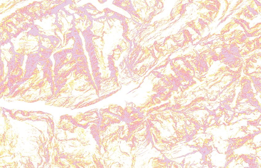
Slope classes over 30 degrees
Derivate representation of the digital terrain model swissALTI3D and models from France, Italy, Austria and Germany, which allows for the identification of inclinations over 30°. According to the recommendation of the Institute for Snow and Avalanche Research SLF the slopes are categorized into 4 classes. They were calculated from a combined digital terrain with a resolution of 10m made up from swissALTI3D for Switzerland and Liechtenstein, RGE ALTI for France, TINITALY for Italy, DGM10 for Austria, DGM1 for Bavaria and EU-DEM for Baden-Württemberg. The precision of the inclination values in the transistional area between the different base models cannot be guaranteed. Liability claims for the representation of gradients over 30° cannot be asserted.
Simple
- Alternate title
-
Slope classes over 30°
- Date (Publication)
- 2016-10-01
- Date (Revision)
- 2023-12-05
- Identifier
- ch.swisstopo.hangneigung-ueber_30
Point of contact
Owner
- Spatial representation type
- Grid
Spatial resolution
- Spatial resolution
- 10 m
- Topic category
-
- C Elevation
Extent
Extent
- Description
-
swissALTIRegio
))

- Maintenance and update frequency
- Annually
- Maintenance note
-
A slope calculation is carried through on the updated parent data set.
- GEMET
-
-
digital land model
-
geographic information system
-
laser
-
- geocat.ch
-
-
GIS (Geographic Information System)
-
3D visualisation
-
3D simulation
-
LIDAR (Light Detection And Ranging)
-
laserscanning
-
DEM (digital elevation model)
-
opendata.swiss
-
- GEMET - INSPIRE themes, version 1.0
-
-
Elevation
-
- geocat.ch
-
-
FSDI Federal Spatial Data Infrastructure
-
Associated resource
- Association Type
- Reference to a master resource of which this one is a part
- Metadata Reference
Associated resource
- Title
-
Höhendaten (Landesvermessung)
- Association Type
- Reference to a master resource of which this one is a part
- Language
- Deutsch
- Character encoding
- UTF8
- Language
- English
- Character encoding
- UTF8
- Basic Geodata
- true
- Basic Geodata ID
-
41.6
- Basic Geodata Legal Level
- Federal
- Distribution format
-
-
nan
-
Digital transfer options
- OnLine resource
-
Vorschau map.geo.admin.ch
Preview map.geo.admin.ch
Digital transfer options
- OnLine resource
-
ch.swisstopo.hangneigung-ueber_30
WMS-FSDI service, layer "Slope classes over 30°"
Digital transfer options
- OnLine resource
-
ch.swisstopo.hangneigung-ueber_30
WMTS-FSDI service, layer "Slope classes over 30°"
Digital transfer options
- OnLine resource
-
swissALTI3D
Digital transfer options
- OnLine resource
-
Französiches Modell RGE ALTI
Digital transfer options
- OnLine resource
-
Italienisches Modell TINITALY/01
Digital transfer options
- OnLine resource
-
Österreichisches Modell DGM10
Digital transfer options
- OnLine resource
-
Bayerisches Modell DGM1
- Number of dimensions
- 3
- Cell geometry
- Point
- Transformation parameter availability
- 1
- Reference system identifier
- EPSG:2056
Metadata
- Metadata identifier
- 77f0637f-8d52-45bc-b824-d6e5719de55b
- Language
- Deutsch
- Character encoding
- UTF8
- Language
- Français
- Character encoding
- UTF8
- Language
- Italiano
- Character encoding
- UTF8
- Language
- English
- Character encoding
- UTF8
- Language
- Rumantsch
- Character encoding
- UTF8
Point of contact
Type of resource
- Resource scope
- Dataset
- Metadata linkage
-
https://www.geocat.ch/geonetwork/srv/api/records/77f0637f-8d52-45bc-b824-d6e5719de55b
- Date info (Creation)
- 2013-06-24T13:22:47Z
- Date info (Revision)
- 2026-04-13T09:27:01.127616Z
Metadata standard
- Title
-
eCH-0271