geocat.ch
Erhebungsgebiet (Lawinen)
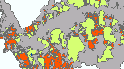
Geographische Bestandsaufnahme von Gebieten, für die Lawinengefahr festgestellt wurde.
Simple
- Alternate title
-
Erhebungsgebiet (Lawinen)
- Date (Creation)
- 2018-01-01
- Date (Revision)
- 2024-10-14
- Identifier
- 426
- Purpose
-
Kartierung von Vermessungsgebieten, überprüften Gebieten.
- Status
- On going
Custodian
- Spatial representation type
- Vector
Spatial resolution
Equivalent scale
- Denominator
- 10000
- Topic category
-
- F Geoscientific information
Extent
Extent
- Description
-
Canton of Valais (VS)
))

- Maintenance and update frequency
- As needed
Resource format
- Title
-
ESRI Enterprise Geodatabase
- Date
- GEMET themes
-
-
disasters, accidents, risk
-
- GEMET - INSPIRE themes, version 1.0
-
-
Natural risk zones
-
- GEMET
-
-
hazard
-
- GEMET
-
-
avalanche
-
- GEMET
-
-
mapping
-
- geocat.ch
-
-
official geodata
-
Resource constraints
- Use limitation
-
Die Richtigkeit, Vollständigkeit, Zuverlässigkeit und Aktualität der Daten kann nicht garantiert werden. Die Daten sind somit nicht rechtsverbindlich.
Resource constraints
- Access constraints
- Other restrictions
- Other constraints
-
Die Geodaten sind öffentlich zugänglich. (Zugangsberechtigungsstufe A nach KGeoIG)
- Other constraints
-
Es gelten die Nutzungsbedingungen für Geodaten des Kantons Wallis ( https://www.vs.ch/de/web/guest/rechtliches).
Associated resource
- Association Type
- Reference from one resource to another
- Metadata Reference
- Language
- Français
- Character encoding
- UTF8
- Subtopic Category
- F3 Natural Hazards
- Basic Geodata
- true
- Basic Geodata ID
-
166>A.1
- Basic Geodata Legal Level
- Cantonal
- Basic Geodata Type
- basicGeodata
- Included with dataset
- 0
- Title
-
Catalogue d'objets: Secteurs de danger avalanche, géodonnées de base No. 166.1
- Date (Creation)
- 2024-01-15
- Distribution format
-
-
ESRI Shapefile (SHP)
-
autres formats sur demande / andere Formate auf Anfrage
-
Distributor
- Statement
-
Karte, die aus einer Studie der überprüften Sektoren erstellt wurde.
- Hierarchy level
- Dataset
- Description
-
Bestimmung durch Raumanalyse
- Geometric object type
- Surface
- Geometric object count
- 1084
- Reference system identifier
- EPSG:2056/CH1903+_LV95
- Title
-
Modèle de représentation: Secteurs de danger avalanche, géodonnées de base No. 166.1
- Date (Creation)
- 2024-01-15
Metadata
- Metadata identifier
- 593073e5-a96d-4758-8d4d-237b240bf9fd
- Language
- Deutsch
- Character encoding
- UTF8
- Language
- Français
- Character encoding
- UTF8
- Language
- Italiano
- Character encoding
- UTF8
- Language
- English
- Character encoding
- UTF8
- Language
- Rumantsch
- Character encoding
- UTF8
Distributor
Type of resource
- Resource scope
- Dataset
- Metadata linkage
-
https://www.geocat.ch/geonetwork/srv/api/records/593073e5-a96d-4758-8d4d-237b240bf9fd
- Date info (Creation)
- 2020-08-28T09:10:57Z
- Date info (Revision)
- 2026-05-07T13:58:22.310873Z
Metadata standard
- Title
-
eCH-0271