geocat.ch
Gefahrenkarten
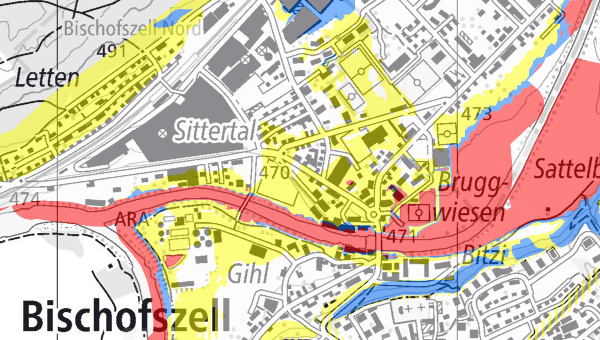
Gefahrenkarten zeigen, wo in der Schweiz Siedlungen und Verkehrswege durch Hochwassergefahren, Rutschungen, Sturzprozesse und Lawinen bedroht sind. Zudem geben sie Auskunft über die zu erwartenden Intensitäten (Ausmass) und die Wahrscheinlichkeit, mit der das Ereignis eintreten kann. Die Daten basieren auf dem MGDM Gefahrenkarten (ID 166.1, Version 1.3).
Simple
- Date (Creation)
- 2016-01-01
Resource provider
- Topic category
-
- F Geoscientific information
Extent
Extent
- Description
-
Switzerland
))

- Maintenance and update frequency
- Daily
- geocat.ch
-
-
natural hazard map
-
hazard map
-
official geodata
-
geodienste.ch
-
minimum geodata model MGDM
-
canton
-
- GEMET
-
-
natural hazard
-
landslide
-
federal law
-
avalanche
-
hazard
-
flooding
-
- Language
- Deutsch
- Character encoding
- UTF8
- Subtopic Category
- F3 Natural Hazards
- Basic Geodata
- true
- Basic Geodata ID
-
166.1
- Basic Geodata Legal Level
- Federal
- Distribution format
-
-
STAC
-
OGC Web Map Service (WMS)
-
OGC Web Feature Service (WFS)
-
OGC Geopackage (GPKG)
-
ESRI Shapefile (SHP)
-
Digital transfer options
- OnLine resource
-
Dokumentation
Report on the implementation of services, data, and attributes.
Digital transfer options
- OnLine resource
-
Daten
WMS
Digital transfer options
- OnLine resource
-
Datenbezug
Data access
Digital transfer options
- OnLine resource
-
STAC
STAC
- Reference system identifier
- EPSG:2056
Metadata
- Metadata identifier
- fbfbf191-c568-49fb-91d5-6a38b142dd20
- Language
- Deutsch
- Character encoding
- UTF8
- Language
- Français
- Character encoding
- UTF8
- Language
- Italiano
- Character encoding
- UTF8
- Language
- English
- Character encoding
- UTF8
Resource provider
Type of resource
- Resource scope
- Dataset
- Metadata linkage
-
https://www.geocat.ch/geonetwork/srv/api/records/fbfbf191-c568-49fb-91d5-6a38b142dd20
- Date info (Creation)
- 2016-01-01T00:00:00.000Z
- Date info (Revision)
- 2026-05-12T23:02:11.975174Z
Metadata standard
- Title
-
GM03_2