geocat.ch
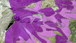
Carte d'intensités des dangers d'avalanche par couloir et processus détaillé
Inventaire géographique des intensités pour les zones exposées à des dangers d'avalanche par source de processus détaillé (avalanche coulante, avalanche poudreuse et glissement du manteau neigeux).
Simple
- Alternate title
-
Intensité par couloir et processus détaillé (avalanche)
- Date (Creation)
- 2019-12-12
- Date (Revision)
- 2025-11-06
- Identifier
- 423
- Purpose
-
Cartographie des intensités permettant d'élaborer les cartes de danger avalanche par couloirs de danger
- Status
- On going
Custodian
- Spatial representation type
- Vector
Spatial resolution
Equivalent scale
- Denominator
- 10000
- Topic category
-
- F Geoscientific information
Extent
Extent
- Description
-
Canton of Valais (VS)
))

- Maintenance and update frequency
- As needed
Resource format
- Title
-
ESRI Enterprise Geodatabase
- Date
- GEMET themes
-
-
disasters, accidents, risk
-
- GEMET - INSPIRE themes, version 1.0
-
-
Natural risk zones
-
- GEMET
-
-
hazard
-
- GEMET
-
-
avalanche
-
- GEMET
-
-
mapping
-
- geocat.ch
-
-
official geodata
-
hazard map
-
- geocat.ch
-
-
outline map
-
Resource constraints
- Use limitation
-
Il n'est pas possible de garantir l'exactitude, l'exhaustivité, la fiabilité et l'actualité des données. Toutes les données sont par conséquent dépourvues de foi publique.
Resource constraints
- Access constraints
- Other restrictions
- Other constraints
-
Géodonnées accessibles au public (niveau A selon l'OGéo).
- Other constraints
-
Les conditions générales d'utilisation des géodonnées du Canton du Valais font foi ( https://www.vs.ch/fr/web/guest/information-legale).
Associated resource
- Association Type
- Reference from one resource to another
- Metadata Reference
- Language
- Français
- Character encoding
- UTF8
- Language
- Deutsch
- Character encoding
- UTF8
- Subtopic Category
- F3 Natural Hazards
- Basic Geodata
- true
- Basic Geodata ID
-
166>A.1
- Basic Geodata Legal Level
- Cantonal
- Basic Geodata Type
- basicGeodata
- Included with dataset
- 0
- Title
-
Catalogue d'objets : Cartes d'intensité pour source et processus des dangers avalanches, géodonnées de base No. 166.1
- Date (Creation)
- 2024-01-15
- Distribution format
-
-
ESRI Shapefile (SHP)
-
autres formats sur demande / andere Formate auf Anfrage
-
Distributor
- Statement
-
Cartes élaborées sur la base d'études réalisées par des bureaux spécialisés
- Hierarchy level
- Dataset
- Description
-
Etudes de terrain et modélisations
- Geometric object type
- Surface
- Geometric object count
- 5659
- Reference system identifier
- EPSG:2056/CH1903+_MN95
- Title
-
Modèle de représentation : Cartes d'intensité pour source et processus des dangers avalanches, géodonnées de base No. 166.1
- Date (Publication)
- 2024-01-15
Metadata
- Metadata identifier
- 29c4d065-5af7-421d-b32d-a3d19b241a76
- Language
- Français
- Character encoding
- UTF8
- Language
- Deutsch
- Character encoding
- UTF8
- Language
- Italiano
- Character encoding
- UTF8
- Language
- English
- Character encoding
- UTF8
- Language
- Rumantsch
- Character encoding
- UTF8
Distributor
Type of resource
- Resource scope
- Dataset
- Metadata linkage
-
https://www.geocat.ch/geonetwork/srv/api/records/29c4d065-5af7-421d-b32d-a3d19b241a76
- Date info (Creation)
- 2020-06-02T15:48:07Z
- Date info (Revision)
- 2026-06-03T14:46:00.992859Z
Metadata standard
- Title
-
eCH-0271