geocat.ch
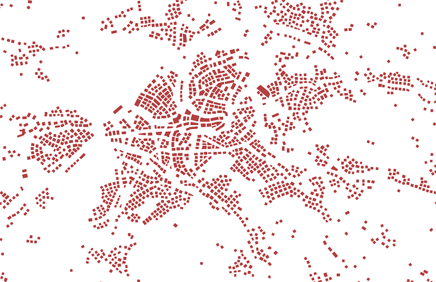
swissTLMRegio Buildings
The Topic Building contains individual buildings. It consists of one feature class.Because of the effects of generalisation, the assigned buildings in the real world are often groups of buildings. Therefore, the topic Building is not suitable for the identification of single buildings but is rather an orientation aid.
Simple
- Alternate title
-
Building generalized swissTLMRegio
- Date (Publication)
- 2012-02-24
- Date (Revision)
- 2025-12-02
- Identifier
- ch.swisstopo.vec200-building
- Other citation details
-
Part of the swissTLMRegio dataset
- Status
- Completed
Point of contact
- Spatial representation type
- Vector
Spatial resolution
Equivalent scale
- Denominator
- 200000
Extent
Extent
- Description
-
swissTLMRegio
Identifier
- Code
))

- Maintenance and update frequency
- Annually
- Hierarchy level
- Dataset
- geocat.ch
-
-
GIS (Geographic Information System)
-
- geocat.ch
-
-
landscape model
-
opendata.swiss
-
- GEMET
-
-
geographic information system
-
- GEMET - INSPIRE themes, version 1.0
-
-
Buildings
-
- geocat.ch
-
-
FSDI Federal Spatial Data Infrastructure
-
Associated resource
- Association Type
- Reference to a master resource of which this one is a part
- Metadata Reference
Associated resource
- Title
-
Topografisches Landschaftsmodell (Landesvermessung)
- Association Type
- Reference to a master resource of which this one is a part
- Language
- English
- Character encoding
- UTF8
- Language
- Deutsch
- Character encoding
- UTF8
- Supplemental Information
-
The topics Transportation, Hydrography, Landcover, Buildings, Miscellaneous, Names and Administrative boundaries build together the dataset swissTLMRegio.
- Basic Geodata
- true
- Basic Geodata ID
-
38.14
- Basic Geodata Legal Level
- Federal
- Distribution format
-
-
ESRI Personal Geodatabase (Personal-GDB)
-
AutoCAD DXF (DXF)
-
ESRI Shapefile (SHP)
-
INTERLIS 2 (XTF)
-
OGC Geopackage (GPKG)
-
Digital transfer options
- OnLine resource
-
Vorschau map.geo.admin.ch
Preview map.geo.admin.ch
Digital transfer options
- OnLine resource
-
ch.swisstopo.vec200-building
WMS-FSDI service, layer "Building generalized swissTLMRegio"
Digital transfer options
- OnLine resource
-
ch.swisstopo.vec200-building
WMTS-FSDI service, layer "Building generalized swissTLMRegio"
Digital transfer options
Digital transfer options
- Statement
-
Based on a 1:200 000 scale. Geometric precision: 20-60 m.
- Hierarchy level
- Dataset
- Topology level
- Full planar graph
- Geometric object type
- Surface
- Geometric object count
- 340228
- Reference system identifier
- EPSG:21781
- Reference system identifier
- EPSG:2056
- Maintenance and update frequency
- Annually
- Date
- 2026-10-15
- Date type
- nextUpdate
Metadata
- Metadata identifier
- fca926e5-99ee-4cc2-bec4-778a5f1ebda5
- Language
- Deutsch
- Character encoding
- UTF8
- Language
- Français
- Character encoding
- UTF8
- Language
- Italiano
- Character encoding
- UTF8
- Language
- English
- Character encoding
- UTF8
- Language
- Rumantsch
- Character encoding
- UTF8
Point of contact
Type of resource
- Resource scope
- Tile
- Name
-
Topic
- Metadata linkage
-
https://www.geocat.ch/geonetwork/srv/api/records/fca926e5-99ee-4cc2-bec4-778a5f1ebda5
- Date info (Creation)
- 2020-10-28T07:19:45Z
- Date info (Revision)
- 2026-04-13T09:15:58.461812Z
Metadata standard
- Title
-
eCH-0271