geocat.ch
swissTLMRegio
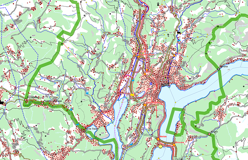
swissTLMRegio is a 2D landscape model, which represents the natural and man-made features of the landscape in vector format. With its high generalisation grade it is a reference dataset for applications requiring a regional or national overview.
swissTLMRegio describes more than one million objects with their location, shape and neighbourhood connections (topology) as well as the object type and further attributes. swissTLMRegiois composed of 6 thematic topics. Each topic contains one or more feature classes: Transportation, Hydrography, Landcover, Buildings, Miscellaneous, Names.
Simple
- Date (Publication)
- 2012-02-24
- Date (Revision)
- 2025-12-02
- Identifier
- ch.swisstopo.swisstlmregio
- Status
- Completed
Point of contact
Owner
- Spatial representation type
- Vector
Spatial resolution
Equivalent scale
- Denominator
- 200000
- Topic category
-
- A Imagery base maps earth cover
- G Biota
- O Structure
- D Boundaries
- I Inland waters
- P Transportation
- C Elevation
Extent
Extent
- Description
-
swissTLMRegio
Identifier
- Code
))

- Maintenance and update frequency
- Annually
- Duration of Conservation
- 275
- Appraisal of Archival Value
- A
- Reason for Archiving Value
- Evidence of business practice
- geocat.ch
-
-
GIS (Geographic Information System)
-
opendata.swiss
-
FSDI Federal Spatial Data Infrastructure
-
- geocat.ch
-
-
individual Symbol
-
- geocat.ch
-
-
official geodata
-
- geocat.ch
-
-
Conservation and archiving planning AAP - Confederation
-
- geocat.ch
-
-
traffic network
-
- GEMET - INSPIRE themes, version 1.0
-
-
Land cover
-
- geocat.ch
-
-
land cover
-
- GEMET - INSPIRE themes, version 1.0
-
-
Buildings
-
- GEMET - INSPIRE themes, version 1.0
-
-
Hydrography
-
- GEMET
-
-
border
-
- GEMET
-
-
geographic information system
-
Resource constraints
- Other constraints
- Opendata BY: Open use. Must provide the source.
Associated resource
- Title
-
Topografisches Landschaftsmodell (Landesvermessung)
- Association Type
- Reference to a master resource of which this one is a part
- Language
- English
- Character encoding
- UTF8
- Language
- Deutsch
- Character encoding
- UTF8
- Subtopic Category
- A1 Base Maps, Landscape Models
- Basic Geodata
- true
- Basic Geodata ID
-
38.11
- Basic Geodata Legal Level
- Federal
- Basic Geodata Type
- Reference Geodata
- Distribution format
-
-
ESRI Shapefile (SHP)
-
INTERLIS 2 (XTF)
-
ESRI File Geodatabase FileGDB (GDB)
-
AutoCAD DXF (DXF)
-
OGC Geopackage (GPKG)
-
Digital transfer options
Digital transfer options
- Statement
-
Based on a 1:200'000 scale. Geometric precision: 20-60 m.
- Hierarchy level
- Dataset
- Topology level
- Topology 1D
- Geometric object type
- Surface
- Geometric object count
- 391807
- Geometric object type
- Curve
- Geometric object count
- 155326
- Geometric object type
- Point
- Geometric object count
- 148215
- Reference system identifier
- EPSG:21781
- Reference system identifier
- EPSG:2056
Metadata
- Metadata identifier
- 2a190233-498a-46c4-91ca-509a97d797a2
- Language
- Deutsch
- Character encoding
- UTF8
- Language
- Français
- Character encoding
- UTF8
- Language
- Italiano
- Character encoding
- UTF8
- Language
- English
- Character encoding
- UTF8
Point of contact
Type of resource
- Resource scope
- Dataset
- Metadata linkage
-
https://www.geocat.ch/geonetwork/srv/api/records/2a190233-498a-46c4-91ca-509a97d797a2
- Date info (Creation)
- 2020-10-28T07:23:03Z
- Date info (Revision)
- 2026-04-13T09:38:41.378677Z
Metadata standard
- Title
-
eCH-0271