geocat.ch
swissTLMRegio Buildings
swissTLMRegio Buildings
swissTLMRegio Buildings
swissTLMRegio Buildings
swissTLMRegio Buildings
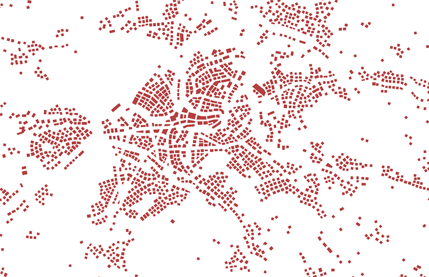
Der Topic Buildings umfasst die Einzelgebäude. Er besteht aus einer Feature Class. Die zugewiesenen Gebäude sind wegen der massstabsbedingten starken Generalisierung in Wirklichkeit häufig Gebäudegruppen bzw. Blöcke. Der Topic Building dient somit nicht der Identifikation von Einzelgebäuden, sondern stellt eher eine Orientierungshilfe dar.
Le Topic Buildings comprend les bâtiments isolés. Il est composé d'une feature class. Les bâtiments saisis représentent, du fait de la forte généralisation liée à l'échelle, en réalité souvent des groupes de bâtiments. Le Topic Buildings ne sert par conséquent pas à l'identification de bâtiments isolés mais représente plutôt un moyen d'orientation auxiliaire.
Il topic Buildings comprende gli edifici isolati. È composto da una feature class. Per via della forte generalizzazione, in realtà gli edifici assegnati al topic sono spesso gruppi di edifici o blocchi. Il topic Building non serve dunque all'identificazione di edifici isolati, ma costituisce piuttosto uno strumento di orientamento.
The Topic Building contains individual buildings. It consists of one feature class.Because of the effects of generalisation, the assigned buildings in the real world are often groups of buildings. Therefore, the topic Building is not suitable for the identification of single buildings but is rather an orientation aid.
Il topic Buildings cumpiglia ils edifizis singuls. El consista d'ina feature class. Ils edifizis attribuids èn, pervia da la ferma generalisaziun liada a la scala, en realitad savens gruppas d'edifizis resp. blocs. Il topic Buildings na serva pia betg a definir edifizis singuls, mabain è in agid d'orientaziun.
Simple
-
Autre titreAltri nomi o acronimiAlternate titleAlternate titleAlternativtitel
-
Einzelgebäude gen. swissTLMRegio
Bâtiments gén. swissTLMRegio
Edifici gen. swissTLMRegio
Building generalized swissTLMRegio
Edifizis generalis. swissTLMRegio
-
Date (Publication)Data (Pubblicazione)Date (Publication)Date (Publication)Datum (Publikation)
- 2012-02-24
-
Date (Révision)Data (Revisione)Date (Revision)Date (Revision)Datum (Aktualisierung)
- 2025-12-02
-
IdentifiantIdentificatoreIdentifierIdentifierKennung
- ch.swisstopo.vec200-building
-
Autres informations de référenceAltre informazioni di riferimentoOther citation detailsOther citation detailsWeitere Referenzinformationen
-
Teil des swissTLMRegio Datensatzes
Fait partie du jeu de données swissTLMRegio
Part of the swissTLMRegio dataset
-
ÉtatStatoStatusStatusBearbeitungsstatus
-
TerminéCompletatoCompletedCompletedAbgeschlossen
Point de contact
Punto di contatto
Point of contact
Point of contact
Ansprechpartner
-
Type de représentation spatialeTipo di rappresentazione spazialeSpatial representation typeSpatial representation typeRäumliche Darstellungsart
-
vecteurVettorialeVectorVectorVektor
Résolution spatiale
Risoluzione spaziale
Spatial resolution
Spatial resolution
Räumliche Auflösung
Fraction représentative
Frazione rappresentativa
Equivalent scale
Equivalent scale
Vergleichsmassstab
-
DénominateurDenominatoreDenominatorDenominatorMassstabszahl
- 200000
Étendue
Estensione
Extent
Extent
Ausdehnung
Étendue
Estensione
Extent
Extent
Ausdehnung
-
DescriptionDescrizioneDescriptionDescriptionBeschreibung
-
swissTLMRegio
swissTLMRegio
swissTLMRegio
swissTLMRegio
Identifiant
Identificativo
Identifier
Identifier
Identifikator
-
CodeCodiceCodeCodeCode
))

-
Fréquence de mise à jourFrequenza di aggiornamentoMaintenance and update frequencyMaintenance and update frequencyWartungsintervall
-
AnnuelleAnnualmenteAnnuallyAnnuallyJährlich
-
NiveauLivelloHierarchy levelHierarchy levelBezugsebene
-
Jeu de donnéesSet di datiDatasetDatasetDatenbestand
- geocat.ch
-
-
SIG (Système d'Information Géographique)
SIG (Sistema Informativo Geografico)
GIS (Geographic Information System)
-
- geocat.ch
-
-
modèle du territoire
modello del territorio
landscape model
-
opendata.swiss
opendata.swiss
opendata.swiss
opendata.swiss
-
- GEMET
-
-
système d'information géographique
sistema informativo geografico
geographic information system
-
- GEMET - INSPIRE themes, version 1.0
-
-
Bâtiments
Edifici
Buildings
-
- geocat.ch
-
-
BGDI Bundesgeodaten-Infrastruktur
IFDG l’Infrastructure Fédérale de données géographiques
IFDG Infrastruttura federale dei dati geografici
FSDI Federal Spatial Data Infrastructure
-
Ressource associée
Risorsa associata
Associated resource
Associated resource
Verlinkte Ressource
-
Type d'associationTipo di associazioneAssociation TypeAssociation TypeAssoziationstyp
-
Citation de travail plus largeCitazione di un'opera più ampiaReference to a master resource of which this one is a partReference to a master resource of which this one is a partÜbergeordneter Datenbestand
-
Metadata ReferenceRiferimento metadatiMetadata ReferenceMetadata ReferenceMetadatenreferenz
Ressource associée
Risorsa associata
Associated resource
Associated resource
Verlinkte Ressource
-
TitreTitoloTitleTitleTitel
-
Topografisches Landschaftsmodell (Landesvermessung)
Modèle topographique du paysage (mensuration nationale)
Modello topografico del paesaggio (misurazione nazionale)
-
Type d'associationTipo di associazioneAssociation TypeAssociation TypeAssoziationstyp
-
Citation de travail plus largeCitazione di un'opera più ampiaReference to a master resource of which this one is a partReference to a master resource of which this one is a partÜbergeordneter Datenbestand
-
LangueLinguaLanguageLanguageSprache
- English
-
Encodage de caractèresCodifica dei caratteriCharacter encodingCharacter encodingZeichenkodierung
-
Utf8UTF8UTF8UTF8Utf8
-
LangueLinguaLanguageLanguageSprache
- Deutsch
-
Encodage de caractèresCodifica dei caratteriCharacter encodingCharacter encodingZeichenkodierung
-
Utf8UTF8UTF8UTF8Utf8
-
Informations supplémentairesInformazioni supplementariSupplemental InformationSupplemental InformationZusätzliche Informationen
-
Die Topics Transportation, Hydrography, Landcover, Buildings, Miscellaneous, Names und Administrative boundaries bilden zusammen den Datensatz swissTLMRegio.
Les topics Transportation, Hydrography, Landcover, Buildings, Miscellaneous, Names et Administrative boundaries forment ensemble le jeu de données swissTLMRegio.
The topics Transportation, Hydrography, Landcover, Buildings, Miscellaneous, Names and Administrative boundaries build together the dataset swissTLMRegio.
-
Géodonnées de baseGeodati di baseBasic GeodataBasic GeodataGeobasisdaten
- true
-
Identifiant Géodonnées de baseIdentificativo dei geodati di baseBasic Geodata IDBasic Geodata IDIdentifikator des Geobasisdatensatzes
-
38.14
-
Niveau des géodonnées de baseLivello legale dei geodati di baseBasic Geodata Legal LevelBasic Geodata Legal LevelGeobasisdatenebene
-
FédéralFederaleFederalFederalNational
-
Format de distributionFormato (codifica)Distribution formatDistribution formatAbgabeformat
-
-
ESRI Personal Geodatabase (Personal-GDB)
-
AutoCAD DXF (DXF)
-
ESRI Shapefile (SHP)
-
INTERLIS 2 (XTF)
-
OGC Geopackage (GPKG)
-
Options de transfert numérique
Opzioni di trasferimento digitale
Digital transfer options
Digital transfer options
Optionen für die digitale Übertragung
-
Ressource en ligneRisorsa onlineOnLine resourceOnLine resourceOnline
-
Vorschau map.geo.admin.ch
Vorschau map.geo.admin.chAperçu map.geo.admin.chPrevisione map.geo.admin.chPreview map.geo.admin.ch
Options de transfert numérique
Opzioni di trasferimento digitale
Digital transfer options
Digital transfer options
Optionen für die digitale Übertragung
-
Ressource en ligneRisorsa onlineOnLine resourceOnLine resourceOnline
-
ch.swisstopo.vec200-building
WMS-BGDI Dienst, Layer "Einzelgebäude gen. swissTLMRegio"Service WMS-IFDG, couche "Bâtiments gén. swissTLMRegio"Servizio WMS-IFDG, strato "Edifici gen. swissTLMRegio"WMS-FSDI service, layer "Building generalized swissTLMRegio"WMS-BGDI Dienst, Layer "Einzelgebäude gen. swissTLMRegio"
Options de transfert numérique
Opzioni di trasferimento digitale
Digital transfer options
Digital transfer options
Optionen für die digitale Übertragung
-
Ressource en ligneRisorsa onlineOnLine resourceOnLine resourceOnline
-
ch.swisstopo.vec200-building
WMTS-BGDI Dienst, Layer "Einzelgebäude gen. swissTLMRegio"Service WMTS-IFDG, couche , Layer "Bâtiments gén. swissTLMRegio"Servizio WMTS-IFDG, strato "Edifici gen. swissTLMRegio"WMTS-FSDI service, layer "Building generalized swissTLMRegio"WMTS-BGDI Dienst, Layer "Einzelgebäude gen. swissTLMRegio"
Options de transfert numérique
Opzioni di trasferimento digitale
Digital transfer options
Digital transfer options
Optionen für die digitale Übertragung
Options de transfert numérique
Opzioni di trasferimento digitale
Digital transfer options
Digital transfer options
Optionen für die digitale Übertragung
Options de transfert numérique
Opzioni di trasferimento digitale
Digital transfer options
Digital transfer options
Optionen für die digitale Übertragung
-
Généralités sur la provenanceInformazioni generali sulla provenienzaStatementStatementErklärung
-
Auf einem 1:200 000 Massstab basierend. Lagegenauigkeit: 20-60 m.
Se base sur une échelle au 1:200 000. Précision de position: 20-60 m.
Based on a 1:200 000 scale. Geometric precision: 20-60 m.
-
NiveauLivelloHierarchy levelHierarchy levelBezugsebene
-
Jeu de donnéesSet di datiDatasetDatasetDatenbestand
-
Niveau de topologieLivello di topologiaTopology levelTopology levelTopologieebene
-
Topologie de réseau complèteGrafo planare completoFull planar graphFull planar graphVollständige Netzwerktopologie
-
Type d’objet géométriqueTipo di oggetto geometricoGeometric object typeGeometric object typeTyp des geometrischen Objekts
-
PolygoneSuperficieSurfaceSurfacesurface
-
Nombre d’objets géométriquesNumero di oggetti geometriciGeometric object countGeometric object countAnzahl geometrischer Objekte
- 340228
-
Nom du système de référenceNome del sistema di riferimentoReference system identifierReference system identifierName des Referenzsystems
- EPSG:21781
-
Nom du système de référenceNome del sistema di riferimentoReference system identifierReference system identifierName des Referenzsystems
- EPSG:2056
-
Fréquence de mise à jourFrequenza di aggiornamentoMaintenance and update frequencyMaintenance and update frequencyWartungsintervall
-
AnnuelleAnnualmenteAnnuallyAnnuallyJährlich
-
DateDataDateDateDatum
- 2026-10-15
-
Type de dateTipo di dataDate typeDate typeDatumsart
-
nextUpdatenextUpdatenextUpdatenextUpdatenextUpdate
Metadata
-
Identifiant des métadonnéesIdentificativo della schedaMetadata identifierMetadata identifierIdentifikator des Metadatensatzes
- fca926e5-99ee-4cc2-bec4-778a5f1ebda5
-
LangueLinguaLanguageLanguageSprache
- Deutsch
-
Encodage de caractèresCodifica dei caratteriCharacter encodingCharacter encodingZeichenkodierung
-
Utf8UTF8UTF8UTF8Utf8
-
LangueLinguaLanguageLanguageSprache
- Français
-
Encodage de caractèresCodifica dei caratteriCharacter encodingCharacter encodingZeichenkodierung
-
Utf8UTF8UTF8UTF8Utf8
-
LangueLinguaLanguageLanguageSprache
- Italiano
-
Encodage de caractèresCodifica dei caratteriCharacter encodingCharacter encodingZeichenkodierung
-
Utf8UTF8UTF8UTF8Utf8
-
LangueLinguaLanguageLanguageSprache
- English
-
Encodage de caractèresCodifica dei caratteriCharacter encodingCharacter encodingZeichenkodierung
-
Utf8UTF8UTF8UTF8Utf8
-
LangueLinguaLanguageLanguageSprache
- Rumantsch
-
Encodage de caractèresCodifica dei caratteriCharacter encodingCharacter encodingZeichenkodierung
-
Utf8UTF8UTF8UTF8Utf8
Point de contact
Punto di contatto
Point of contact
Point of contact
Ansprechpartner
-
Heures de serviceOrario di servizioHours of serviceHours of serviceBetriebszeiten
-
08h30 - 11h00 / 14h00 - 16h00 GMT+1
Type de ressource
Tipo di risorsa
Type of resource
Type of resource
Anwendungsbereich der Metadaten
-
Domaine d'application de la ressourceAmbito di applicazione della risorsaResource scopeResource scopeDomäne der Ressourcenanwendung
-
MosaïqueTesseraTileTileKachel
-
NomNomeNameNameName
-
Topic
-
Lien vers la métadonnéeCollegamento ai metadatiMetadata linkageMetadata linkageLink zu den Metadaten
-
Informations de date (Création)Informazioni sulla data (Creazione)Date info (Creation)Date info (Creation)Datumsangaben (Erstellung)
- 2020-10-28T07:19:45Z
-
Informations de date (Révision)Informazioni sulla data (Revisione)Date info (Revision)Date info (Revision)Datumsangaben (Aktualisierung)
- 2026-04-13T09:15:58.461812Z
Norme des métadonnées
Standard dei metadati
Metadata standard
Metadata standard
Metadatenstandard
-
TitreTitoloTitleTitleTitel
-
eCH-0271