geocat.ch
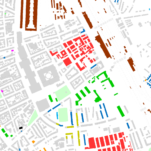
Stadtfunktionen Basel 1961
Grundlage für die Kartierung der Stadtfunktionen sind das Adressbuch der Stadt Basel von 1961, der Zonenplan von 1969 (insbesondere, was die Industrieareale betrifft) sowie eine Kartierung der Genossenschaftsbauten und der «Baumgartnerhäuser». Kartengrundlage: Geodaten Kanton Basel-Stadt, korrigiert auf das Datum 1961. Zeichnung Andreas Kettner, 2025.
Simple
- Date (Creation)
- 2025-01-01
- Status
- Completed
Owner
- Spatial representation type
- Grid
Spatial resolution
- Spatial resolution
- 0.25 m
Spatial resolution
Equivalent scale
- Denominator
- 5000
- Topic category
-
- A Imagery base maps earth cover
Extent
Extent
- Description
-
Canton of Basel-Stadt (BS)
))

- Maintenance and update frequency
- Not planned
- geocat.ch
-
-
historic map
-
- geocat.ch
-
-
survey plan
-
- geocat.ch
-
-
opendata.swiss
-
Resource constraints
- Other constraints
-
Die Geodaten sind öffentlich zugänglich. (Zugangsberechtigungsstufe [A] = öffentlich)
- Other constraints
-
Es gelten die Nutzungsbedingungen für Geodaten des Kantons Basel-Stadt. ( http://www.geo.bs.ch/agb)
Associated resource
- Association Type
- Resource is a description of associated resource
- Metadata Reference
Associated resource
- Title
-
Historische Pläne
- Association Type
- Reference to a master resource of which this one is a part
- Language
- Deutsch
- Character encoding
- UTF8
- Supplemental Information
-
Herausgegeben vom Baudepartement des Kantons Basel-Stadt. Nach den Original-Plänen des Baudepartements reduziert, gestochen und gedruckt von Wassermann & Schäublin, Basel.
- Subtopic Category
- A1 Base Maps, Landscape Models
- Basic Geodata
- false
- Basic Geodata Type
- openData
- Distribution format
-
-
GeoTIFF (GEOTIFF)
-
Tagged Image File Format (TIFF)
-
JPEG (JPG)
-
Distributor
- Hours of service
-
Mo - Do: 8:00 bis 12:00, 13:30 bis 16:30, Fr: 8:00 bis 12:00, 13:30 bis 16:00
Digital transfer options
- OnLine resource
-
MapBS
Öffentliches Auskunftssystem des Kantons Basel-Stadt
Digital transfer options
- OnLine resource
-
Geodaten-Shop
Öffentlich zugänglicher Geodaten-Downloaddienst des Kantons Basel-Stadt
Digital transfer options
- OnLine resource
-
WMS BS
Die derzeit im WMS BS verfügbaren Datenebenen entsprechen, bis auf wenige Ausnahmen, den Geodaten, welche auch in MapBS dargestellt sind. Der WMS BS ist kostenlos nutzbar und bietet Zugriff auf öffentliche sowie beschränkt öffentliche Geodaten, wobei gegebenenfalls Benutzername und Passwort benötigt werden (Zugangsdaten von MapBS).
Digital transfer options
- OnLine resource
-
Permalink opendata.swiss
Permalink opendata.swiss
- Reference system identifier
- CH1903+ / LV95/EPSG: 2056
Metadata
- Metadata identifier
- fb316e79-cee3-468c-b7b7-112713a0ca20
- Language
- Deutsch
- Character encoding
- UTF8
- Language
- Français
- Character encoding
- UTF8
- Language
- Italiano
- Character encoding
- UTF8
- Language
- English
- Character encoding
- UTF8
Custodian
Type of resource
- Resource scope
- Dataset
- Metadata linkage
-
https://www.geocat.ch/geonetwork/srv/api/records/fb316e79-cee3-468c-b7b7-112713a0ca20
- Date info (Creation)
- 2025-10-01T11:16:15.318Z
- Date info (Revision)
- 2026-04-13T09:17:50.55247Z
Metadata standard
- Title
-
eCH-0271