geocat.ch
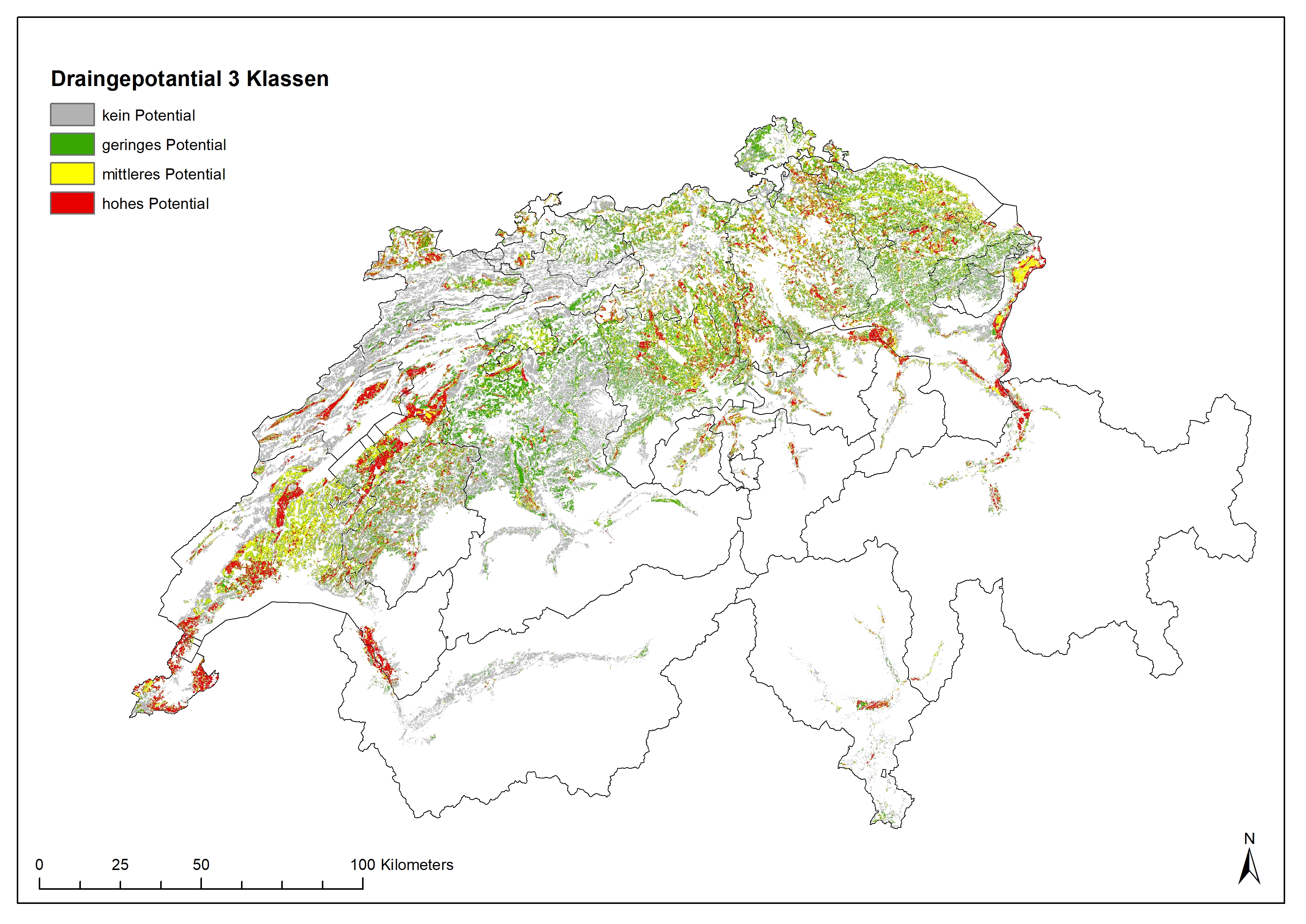
Drainagepotentialkarte Schweiz; klassifiziert, 3 Klassen
Carte de drainage de la Suisse; catégorisier en 3 divisions
Drainage Map for Switzerland, classified in 3 subdivisions
Drainagekarte Schweiz
– Karte potentiell drainierter Flächen der Schweiz
Für viele Landwirtschaftsflächen gibt es keine, oder nur ungenaue Angaben zu Drainagen, deren Lage, Zustand und durch sie entwässerter Fläche. Die Digitalisierung von vorhandenen Drainagedaten ist bei den meisten Kantonen noch in der Umsetzung, nur wenige Kantone bieten Daten zu drainierten Flächen über das Geoportal an (Stand 2019). Diese mittels eines Machine Learning - Algorithmus erstellten Karten liefern einen nationalen Überblick über die mögliche bzw. wahrscheinliche Verbreitung von drainierten Flächen, aufgrund von Umweltdaten. Als Trainingsdaten wurden die vorhandenen Daten zu Drainagen von insgesamt 10 Kantonen (AG, BE, BL, BS, FR, GE, NE, SH, SG, ZH) verwendet. Die Berechnung erfolgte Kantonsweise, es dienten jeweils die geographisch nächstliegenden Kantone als Trainingsdaten. Basis für die Modellierung waren Umweltparameter wie Hangneigung, Bodeneigenschaften, Geologie, (ehemalige) Sumpf-und Moor-Gebiete und Eignung für Ackerland.
Der Datensatz zeigt Wahrscheinlichkeiten für eine Drainage aufgrund der Umweltfaktoren. Felddaten müssen zusätzlich erhoben werden.
Stand der Daten: 2019
Zitat:
Ulrike Koch, Volker Prasuhn «Drainagekarte Schweiz - Erstellung einer Karte potentiell drainierter Flächen in der Schweiz mittels «Machine Learning». Agroscope Science | Nr. 104 / 2020
-- résumé --
Potentially Drained Land Use Areas in Switzerland
For many land use areas it is still unknown if they are drained. This is due to the age of many drainages and the fact that digitalization of drainages is not completed now. Only some cantons provide data to drainages on their geo-platforms. Using a machine – learning algorithms we modelled the potential of drainages from environmental parameters like slope, soil, (former) wetlands, geo-cover. Ten (AG, BE, BL, BS, FR, GE, NE, SH, SG, ZH) cantons provided geodata on drained land. These data served as training datasets for calibrating the models, and hence for predicting the land for which no information on drainage systems was available. The drainage maps provides a national overview of the possible or probable distribution of drained areas in Switzerland. In individual cases, however, detailed clarifications must be in the field with the farmer and/or the municipality or canton.
Ulrike Koch, Volker Prasuhn «Drainagekarte Schweiz - Erstellung einer Karte potentiell drainierter Flächen in der Schweiz mittels «Machine Learning». Agroscope Science | Nr. 104 / 2020
Simple
-
Autre titreAltri nomi o acronimiAlternate titleAlternate titleAlternativtitel
-
Potentiell drainierte Landnutzungsflächen
Surfaces potentiellement drainées en Suisse
Potentially drained landuse areas in Switzerland
-
Date (Publication)Data (Pubblicazione)Date (Publication)Date (Publication)Datum (Publikation)
- 2020-04-14
-
IdentifiantIdentificatoreIdentifierIdentifierKennung
- -- techn Layername / nom technique de la couche --
-
ÉtatStatoStatusStatusBearbeitungsstatus
-
TerminéCompletatoCompletedCompletedAbgeschlossen
Propriétaire
Proprietario
Owner
Owner
Eigentümer
Dépositaire
Custode
Custodian
Custodian
Verwalter
-
Type de représentation spatialeTipo di rappresentazione spazialeSpatial representation typeSpatial representation typeRäumliche Darstellungsart
-
grilleRasterGridGridRaster, Gitter
Résolution spatiale
Risoluzione spaziale
Spatial resolution
Spatial resolution
Räumliche Auflösung
Fraction représentative
Frazione rappresentativa
Equivalent scale
Equivalent scale
Vergleichsmassstab
-
DénominateurDenominatoreDenominatorDenominatorMassstabszahl
- 10000
Résolution spatiale
Risoluzione spaziale
Spatial resolution
Spatial resolution
Räumliche Auflösung
-
Distance de résolutionDistanza di risoluzioneSpatial resolutionSpatial resolutionDistanz
- 25 m
-
Catégorie de thèmeCategoria ISOTopic categoryTopic categoryThematik
-
-
F Informations géoscientifiquesF Informazioni geoscientificheF Geoscientific informationF Geoscientific informationF Erdwissenschaften
-
Étendue
Estensione
Extent
Extent
Ausdehnung
Étendue
Estensione
Extent
Extent
Ausdehnung
-
DescriptionDescrizioneDescriptionDescriptionBeschreibung
-
Switzerland
Schweiz
Suisse
Svizzera
Svizra
))

-
Fréquence de mise à jourFrequenza di aggiornamentoMaintenance and update frequencyMaintenance and update frequencyWartungsintervall
-
Comme nécessaireSecondo necessitàAs neededAs neededBei Bedarf
Format de la ressource
Formato della risorsa
Resource format
Resource format
Format der Ressource
-
TitreTitoloTitleTitleTitel
-
Tagged Image File Format (TIFF)
-
DateDataDateDateDatum
- geocat.ch
-
-
région agricole
regione agricola
agricultural region
-
opendata.swiss
opendata.swiss
opendata.swiss
opendata.swiss
-
confédération
confederazione
confederation
-
cours d'eau
corso d'acqua
watercourse
-
conduite d'eau
condotta d'acqua
water pipe
-
surface agricole utile SAU
superficie agricola utile SAU
usable agricultural area UAA
-
- GEMET
-
-
drainage
drenaggio
drainage
-
conservation de l'eau
conservazione delle acque
water conservation
-
paysage cultivé
paesaggio coltivato
agricultural landscape
-
modélisation
modellistica
modelling
-
eau
acqua
water
-
- GEMET themes
-
-
agriculture
agricoltura
agriculture
-
eau
acqua
water
-
zones naturelles, paysages, écosystèmes
aree naturali, paesaggio, ecosistemi
natural areas, landscape, ecosystems
-
recherche
ricerca
research
-
géographie
geografia
geography
-
Contraintes sur la ressource
Vincoli sulle risorse
Resource constraints
Resource constraints
Ressourcenbeschränkungen
-
Limitation d'utilisationLimitazione d'usoUse limitationUse limitationNutzungsbeschränkung
-
Disclaimer:
Die in diesen Karten enthaltenen Angaben dienen allein zur Information der Leserschaft. Aus den Daten und Karten können keine punkt- und parzellenscharfen Informationen abgeleitet werden. Agroscope ist bemüht, korrekte, aktuelle und vollständige Informationen zur Verfügung zu stellen – übernimmt dafür jedoch keine Gewähr. Die Autorinnen und Autoren, Agroscope, sowie die beteiligten Institutionen der Autorinnen und Autoren schliessen jede Haftung für eventuelle Schäden im Zusammenhang mit der Umsetzung der darin enthaltenen Informationen aus. Für die Leserschaft gelten die in der Schweiz gültigen Gesetze und Vorschriften, die aktuelle Rechtsprechung ist anwendbar.
-
Contraintes d'accèsVincoli di accessoAccess constraintsAccess constraintsZugriffsbeschränkungen
-
Droit d’auteurCopyrightCopyrightCopyrightUrheberrecht
-
Contraintes d'utilisationVincoli d'usoUse constraintsUse constraintsNutzungseinschränkungen
-
Droit d’auteurCopyrightCopyrightCopyrightUrheberrecht
-
Autres contraintesAltri vincoliOther constraintsOther constraintsAndere Einschränkungen
- Opendata OPEN: Freie Nutzung. Zitat der Publikation ist PflichtOpendata OPEN: Utilisation libre. Citation de la publication est obligatoire.Opendata OPEN: Libero utilizzo. Citazione della pubblicazione è obbligatoria.Opendata OPEN: Open use.Citation of publication reference is obligatory
-
LangueLinguaLanguageLanguageSprache
- Deutsch
-
Encodage de caractèresCodifica dei caratteriCharacter encodingCharacter encodingZeichenkodierung
-
Utf8UTF8UTF8UTF8Utf8
-
Catégorie de sous-thèmeCategoria di sottotemaSubtopic CategorySubtopic CategoryThematische Unterkategorien
-
F2 SolsF2 SuoliF2 SoilsF2 SoilsF2 Boden
-
Géodonnées de baseGeodati di baseBasic GeodataBasic GeodataGeobasisdaten
- false
-
Niveau des géodonnées de baseLivello legale dei geodati di baseBasic Geodata Legal LevelBasic Geodata Legal LevelGeobasisdatenebene
-
FédéralFederaleFederalFederalNational
-
Type de géodonnées de baseTipo di geodati di baseBasic Geodata TypeBasic Geodata TypeGeobasisdatentyp
-
openDataopenDataopenDataopenDataopenData
-
Type d’objet géométriqueTipo di oggetto geometricoGeometric object typeGeometric object typeTyp des geometrischen Objekts
-
PolygoneSuperficieSurfaceSurfacesurface
-
Nom du système de référenceNome del sistema di riferimentoReference system identifierReference system identifierName des Referenzsystems
- LV95 EPSG:2056
-
Fréquence de mise à jourFrequenza di aggiornamentoMaintenance and update frequencyMaintenance and update frequencyWartungsintervall
-
Comme nécessaireSecondo necessitàAs neededAs neededBei Bedarf
Metadata
-
Identifiant des métadonnéesIdentificativo della schedaMetadata identifierMetadata identifierIdentifikator des Metadatensatzes
- f0b19a50-c328-4c31-bdb5-61eecd987d8a
-
LangueLinguaLanguageLanguageSprache
- Deutsch
-
Encodage de caractèresCodifica dei caratteriCharacter encodingCharacter encodingZeichenkodierung
-
Utf8UTF8UTF8UTF8Utf8
-
LangueLinguaLanguageLanguageSprache
- Français
-
Encodage de caractèresCodifica dei caratteriCharacter encodingCharacter encodingZeichenkodierung
-
Utf8UTF8UTF8UTF8Utf8
-
LangueLinguaLanguageLanguageSprache
- Italiano
-
Encodage de caractèresCodifica dei caratteriCharacter encodingCharacter encodingZeichenkodierung
-
Utf8UTF8UTF8UTF8Utf8
-
LangueLinguaLanguageLanguageSprache
- English
-
Encodage de caractèresCodifica dei caratteriCharacter encodingCharacter encodingZeichenkodierung
-
Utf8UTF8UTF8UTF8Utf8
-
LangueLinguaLanguageLanguageSprache
- Rumantsch
-
Encodage de caractèresCodifica dei caratteriCharacter encodingCharacter encodingZeichenkodierung
-
Utf8UTF8UTF8UTF8Utf8
Dépositaire
Custode
Custodian
Custodian
Verwalter
Type de ressource
Tipo di risorsa
Type of resource
Type of resource
Anwendungsbereich der Metadaten
-
Domaine d'application de la ressourceAmbito di applicazione della risorsaResource scopeResource scopeDomäne der Ressourcenanwendung
-
Jeu de donnéesSet di datiDatasetDatasetDatenbestand
-
Lien vers la métadonnéeCollegamento ai metadatiMetadata linkageMetadata linkageLink zu den Metadaten
-
Informations de date (Création)Informazioni sulla data (Creazione)Date info (Creation)Date info (Creation)Datumsangaben (Erstellung)
- 2023-04-25T12:36:23.361Z
-
Informations de date (Révision)Informazioni sulla data (Revisione)Date info (Revision)Date info (Revision)Datumsangaben (Aktualisierung)
- 2026-06-15T09:18:33.731874Z
Norme des métadonnées
Standard dei metadati
Metadata standard
Metadata standard
Metadatenstandard
-
TitreTitoloTitleTitleTitel
-
eCH-0271