geocat.ch
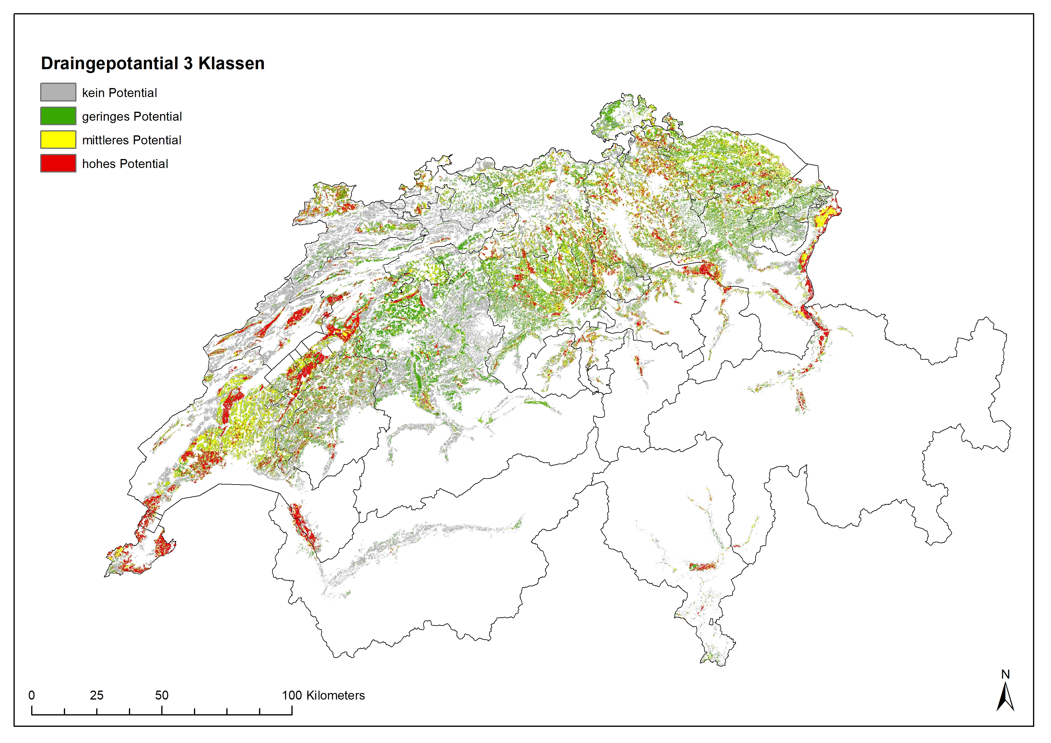
Drainage Map for Switzerland, classified in 3 subdivisions
Potentially Drained Land Use Areas in Switzerland
For many land use areas it is still unknown if they are drained. This is due to the age of many drainages and the fact that digitalization of drainages is not completed now. Only some cantons provide data to drainages on their geo-platforms. Using a machine – learning algorithms we modelled the potential of drainages from environmental parameters like slope, soil, (former) wetlands, geo-cover. Ten (AG, BE, BL, BS, FR, GE, NE, SH, SG, ZH) cantons provided geodata on drained land. These data served as training datasets for calibrating the models, and hence for predicting the land for which no information on drainage systems was available. The drainage maps provides a national overview of the possible or probable distribution of drained areas in Switzerland. In individual cases, however, detailed clarifications must be in the field with the farmer and/or the municipality or canton.
Ulrike Koch, Volker Prasuhn «Drainagekarte Schweiz - Erstellung einer Karte potentiell drainierter Flächen in der Schweiz mittels «Machine Learning». Agroscope Science | Nr. 104 / 2020
Simple
- Alternate title
-
Potentially drained landuse areas in Switzerland
- Date (Publication)
- 2020-04-14
- Identifier
- -- techn Layername / nom technique de la couche --
- Status
- Completed
Owner
Custodian
- Spatial representation type
- Grid
Spatial resolution
Equivalent scale
- Denominator
- 10000
Spatial resolution
- Spatial resolution
- 25 m
- Topic category
-
- F Geoscientific information
Extent
Extent
- Description
-
Switzerland
))

- Maintenance and update frequency
- As needed
Resource format
- Title
-
Tagged Image File Format (TIFF)
- Date
- geocat.ch
-
-
agricultural region
-
opendata.swiss
-
confederation
-
watercourse
-
water pipe
-
usable agricultural area UAA
-
- GEMET
-
-
drainage
-
water conservation
-
agricultural landscape
-
modelling
-
water
-
- GEMET themes
-
-
agriculture
-
water
-
natural areas, landscape, ecosystems
-
research
-
geography
-
Resource constraints
- Use limitation
-
Disclaimer:
Die in diesen Karten enthaltenen Angaben dienen allein zur Information der Leserschaft. Aus den Daten und Karten können keine punkt- und parzellenscharfen Informationen abgeleitet werden. Agroscope ist bemüht, korrekte, aktuelle und vollständige Informationen zur Verfügung zu stellen – übernimmt dafür jedoch keine Gewähr. Die Autorinnen und Autoren, Agroscope, sowie die beteiligten Institutionen der Autorinnen und Autoren schliessen jede Haftung für eventuelle Schäden im Zusammenhang mit der Umsetzung der darin enthaltenen Informationen aus. Für die Leserschaft gelten die in der Schweiz gültigen Gesetze und Vorschriften, die aktuelle Rechtsprechung ist anwendbar.
- Access constraints
- Copyright
- Use constraints
- Copyright
- Other constraints
- Opendata OPEN: Open use.Citation of publication reference is obligatory
- Language
- Deutsch
- Character encoding
- UTF8
- Subtopic Category
- F2 Soils
- Basic Geodata
- false
- Basic Geodata Legal Level
- Federal
- Basic Geodata Type
- openData
- Geometric object type
- Surface
- Reference system identifier
- LV95 EPSG:2056
- Maintenance and update frequency
- As needed
Metadata
- Metadata identifier
- f0b19a50-c328-4c31-bdb5-61eecd987d8a
- Language
- Deutsch
- Character encoding
- UTF8
- Language
- Français
- Character encoding
- UTF8
- Language
- Italiano
- Character encoding
- UTF8
- Language
- English
- Character encoding
- UTF8
- Language
- Rumantsch
- Character encoding
- UTF8
Custodian
Type of resource
- Resource scope
- Dataset
- Metadata linkage
-
https://www.geocat.ch/geonetwork/srv/api/records/f0b19a50-c328-4c31-bdb5-61eecd987d8a
- Date info (Creation)
- 2023-04-25T12:36:23.361Z
- Date info (Revision)
- 2026-06-15T09:18:33.731874Z
Metadata standard
- Title
-
eCH-0271