geocat.ch
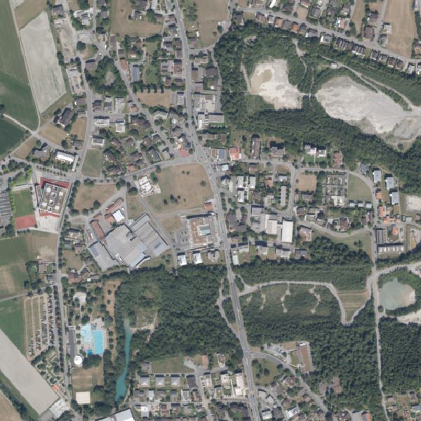
Orthophoto Liechtenstein 2018
Orthophoto Liechtenstein 2018
Orthophoto mit einer Auflösung von 10 cm Bodenpixel. Es wurde am 1./16. August sowie am 11./20. September 2018 geflogen und liegt in Echtfarben (RGB) vor. Das ganze Land inkl. Nachbarregion besteht aus 131 Kacheln à 2.5 x 2.0 km bzw. 25'000 x 20'000 Pixel (500 Mpx). Eine Kachel hat eine Grösse von 1.39 GB. Generell können auch kleinere oder individuelle Ausschnitte bestellt werden. Liechtenstein kann mit ca. 64 Kacheln abgebildet werden.
Orthophoto with a resolution of 10 cm ground pixels. It was flown on 1/16 August and 11/20 September 2018 and is available in true colour (RGB). The entire country including the neighbouring region consists of 131 tiles of 2.5 x 2.0 km each or 25,000 x 20,000 pixels (500 Mpx). One tile has a size of 1.39 GB. In general, smaller or customised sections can also be ordered. Liechtenstein can be mapped with approx. 64 tiles.
Simple
-
Date (Création)Data (Creazione)Date (Creation)Datum (Erstellung)
- 2019-03-20
-
IdentifiantIdentificatoreIdentifierKennung
- https://metadata.geo.llv.li/f004e045-50b3-42d5-bd46-d11451faf416
-
ButScopoPurposeZweck
-
Grundlagedaten der GDI-Liechtenstein
Basic data of the GDI-Liechtenstein
-
ÉtatStatoStatusBearbeitungsstatus
-
TerminéCompletatoCompletedAbgeschlossen
responsable de la publication
Editore
Publisher
Herausgeber
-
Heures de serviceOrario di servizioHours of serviceBetriebszeiten
-
8:00-11:30 und 13:30-17:00
-
Type de représentation spatialeTipo di rappresentazione spazialeSpatial representation typeRäumliche Darstellungsart
-
grilleRasterGridRaster, Gitter
Résolution spatiale
Risoluzione spaziale
Spatial resolution
Räumliche Auflösung
-
Distance de résolutionDistanza di risoluzioneSpatial resolutionDistanz
- 0.1 m
-
Catégorie de thèmeCategoria ISOTopic categoryThematik
-
-
A Imagerie, cartes de base et occupation du solA Mappe di base con immagini della copertura terrestreA Imagery base maps earth coverA Oberflächenbeschreibung
-
Étendue
Estensione
Extent
Ausdehnung
Étendue
Estensione
Extent
Ausdehnung
-
DescriptionDescrizioneDescriptionBeschreibung
-
Liechtenstein
Liechtenstein
Liechtenstein
Liechtenstein
))

-
Fréquence de mise à jourFrequenza di aggiornamentoMaintenance and update frequencyWartungsintervall
-
ContinueContinuaContinualKontinuierlich
Format de la ressource
Formato della risorsa
Resource format
Format der Ressource
-
TitreTitoloTitleTitel
-
GeoTIFF (GEOTIFF)
-
DateDataDateDatum
- geocat.ch
-
-
mosaïque d'orthophotos numériques en couleur
mosaico di ortofoto digitali a colori
digital color orthophoto mosaic
-
INSPIRE
INSPIRE
INSPIRE
-
orthophoto
ortofoto
orthophoto
-
OpenData
OpenData
OpenData
-
- GEMET - INSPIRE themes, version 1.0
-
-
Ortho-imagerie
Orto immagini
Orthoimagery
-
- GEMET themes
-
-
recherche
ricerca
research
-
- Räumlicher Anwendungsbereich
-
-
Nationales
Nazionali
National
-
Contraintes sur la ressource
Vincoli sulle risorse
Resource constraints
Ressourcenbeschränkungen
-
Contraintes d'accèsVincoli di accessoAccess constraintsZugriffsbeschränkungen
-
Autres restrictionsAltre restrizioniOther restrictionsAndere Beschränkungen
-
Contraintes d'utilisationVincoli d'usoUse constraintsNutzungseinschränkungen
-
Autres restrictionsAltre restrizioniOther restrictionsAndere Beschränkungen
-
Autres contraintesAltri vincoliOther constraintsAndere Einschränkungen
- No limitations to public accessNo limitations to public accessNo limitations to public accessNo limitations to public access
Contraintes sur la ressource
Vincoli sulle risorse
Resource constraints
Ressourcenbeschränkungen
-
Contraintes d'accèsVincoli di accessoAccess constraintsZugriffsbeschränkungen
-
Autres restrictionsAltre restrizioniOther restrictionsAndere Beschränkungen
-
Contraintes d'utilisationVincoli d'usoUse constraintsNutzungseinschränkungen
-
Autres restrictionsAltre restrizioniOther restrictionsAndere Beschränkungen
-
Autres contraintesAltri vincoliOther constraintsAndere Einschränkungen
- No conditions to access and useNo conditions to access and useNo conditions to access and useNo conditions to access and use
-
Autres contraintesAltri vincoliOther constraintsAndere Einschränkungen
- Opendata BY: Freie Nutzung. Quellenangabe ist Pflicht.Opendata BY: Utilisation libre. Obligation d’indiquer la source.Opendata BY: Libero utilizzo. Indicazione della fonte obbligatoria.Opendata BY: Open use. Must provide the source.
-
LangueLinguaLanguageSprache
- Deutsch
-
Encodage de caractèresCodifica dei caratteriCharacter encodingZeichenkodierung
-
Utf8UTF8UTF8Utf8
-
Informations supplémentairesInformazioni supplementariSupplemental InformationZusätzliche Informationen
-
Der Datensatz liegt in einzelnen Kacheln mit einer Grösse von 5 km2 vor
-
Catégorie de sous-thèmeCategoria di sottotemaSubtopic CategoryThematische Unterkategorien
-
A1 Cartes de base, modèles de paysageA1 Mappe di base, modelli paesaggisticiA1 Base Maps, Landscape ModelsA1 Basiskarten, Landschaftsmodelle
-
Catégorie de sous-thèmeCategoria di sottotemaSubtopic CategoryThematische Unterkategorien
-
A3 Images aériennes, satellitesA3 Immagini aeree e satellitariA3 Aerial and Satellite ImageryA3 Luft-, Satellitenbilder
-
Description de l'attributDescrizione dell'attributoAttribute descriptionBeschreibung des Attributs
- RGB-Farbwert
-
Format de distributionFormato (codifica)Distribution formatAbgabeformat
-
-
GeoTIFF (GEOTIFF)
-
Point de contact
Punto di contatto
Point of contact
Ansprechpartner
-
Heures de serviceOrario di servizioHours of serviceBetriebszeiten
-
8:00-11:30 und 13:30-17:00
Options de transfert numérique
Opzioni di trasferimento digitale
Digital transfer options
Optionen für die digitale Übertragung
-
Unités de distributionUnità di distribuzioneUnits of distributionVerteilungseinheiten
-
1 Kachel oder indiv. Ausschnitte
-
Ressource en ligneRisorsa onlineOnLine resourceOnline
-
Homepage ATG, Datenausgabe
Datenausgabestelle der Liechtensteinischen LandesverwaltungData Distribution Office of Liechtensteinischen Landesverwaltung
Options de transfert numérique
Opzioni di trasferimento digitale
Digital transfer options
Optionen für die digitale Übertragung
-
Unités de distributionUnità di distribuzioneUnits of distributionVerteilungseinheiten
-
1 Kachel oder indiv. Ausschnitte
-
Ressource en ligneRisorsa onlineOnLine resourceOnline
-
Geodatenportal der Liechtensteinischen Landesverwaltung
Öffentliche Online-Karten der Liechtensteinischen LandesverwaltungPublic online maps of the Liechtenstein National Administration
Options de transfert numérique
Opzioni di trasferimento digitale
Digital transfer options
Optionen für die digitale Übertragung
-
Unités de distributionUnità di distribuzioneUnits of distributionVerteilungseinheiten
-
1 Kachel oder indiv. Ausschnitte
-
Ressource en ligneRisorsa onlineOnLine resourceOnline
-
OI.OrthoimageCoverage2018
INSPIRE View ServiceINSPIRE View Service
Options de transfert numérique
Opzioni di trasferimento digitale
Digital transfer options
Optionen für die digitale Übertragung
-
Unités de distributionUnità di distribuzioneUnits of distributionVerteilungseinheiten
-
1 Kachel oder indiv. Ausschnitte
-
Ressource en ligneRisorsa onlineOnLine resourceOnline
-
li.abi.orthophoto2018
OGC WMS Service der Liechtensteinen LandesverwaltungOGC WMS Service der Liechtensteinen Landesverwaltung
Options de transfert numérique
Opzioni di trasferimento digitale
Digital transfer options
Optionen für die digitale Übertragung
-
Unités de distributionUnità di distribuzioneUnits of distributionVerteilungseinheiten
-
1 Kachel oder indiv. Ausschnitte
-
Ressource en ligneRisorsa onlineOnLine resourceOnline
-
Download als GeoTiff über das Geodatenportal
Download als GeoTiff über das GeodatenportalDownload as GeoTiff via the geodata portal
-
NiveauLivelloHierarchy levelBezugsebene
-
Jeu de donnéesSet di datiDatasetDatenbestand
Rapport sur la qualité
Rapporto sulla qualità
Report
Qualitätsbericht
Result
Risultato
Result
Ergebnis
-
TitreTitoloTitleTitel
-
VERORDNUNG (EG) Nr. 1089/2010 DER KOMMISSION vom 23. November 2010 zur Durchführung der Richtlinie 2007/2/EG des Europäischen Parlaments und des Rates hinsichtlich der Interoperabilität von Geodatensätzen und -diensten
-
Date (Publication)Data (Pubblicazione)Date (Publication)Datum (Publikation)
- 2010-12-08
-
ExplicationSpiegazioneExplanationErläuterung
-
Gemäss INSPIRE Bestandteil des Themas Orthofotografie
-
Degré de conformitéGrado di conformitàPassKonformitätsgrad
- false
-
Généralités sur la provenanceInformazioni generali sulla provenienzaStatementErklärung
-
Luftbildbefliegung aus einer Flughöhe von ca. 2'200m? über Grund
-
NiveauLivelloHierarchy levelBezugsebene
-
Jeu de donnéesSet di datiDatasetDatenbestand
-
DescriptionDescrizioneDescriptionBeschreibung
-
digitale Luftbilder
-
Nombre de dimensionsNumero di dimensioniNumber of dimensionsAnzahl der Dimensionen
- 2
-
Géométrie de la celluleGeometria della cellaCell geometryZellgeometrie
-
SurfaceAreaAreaFläche
-
Disponibilité des paramètres de transformationDisponibilità dei parametri di trasformazioneTransformation parameter availabilityVerfügbarkeit der Transformationsparameter
- 1
-
Nom du système de référenceNome del sistema di riferimentoReference system identifierName des Referenzsystems
- http://www.opengis.net/def/crs/EPSG/0/2056
-
Nom du système de référenceNome del sistema di riferimentoReference system identifierName des Referenzsystems
- http://www.opengis.net/def/crs/EPSG/0/4936
-
Fréquence de mise à jourFrequenza di aggiornamentoMaintenance and update frequencyWartungsintervall
-
Comme nécessaireSecondo necessitàAs neededBei Bedarf
Metadata
-
Identifiant des métadonnéesIdentificativo della schedaMetadata identifierIdentifikator des Metadatensatzes
- f004e045-50b3-42d5-bd46-d11451faf416
-
LangueLinguaLanguageSprache
- Deutsch
-
Encodage de caractèresCodifica dei caratteriCharacter encodingZeichenkodierung
-
Utf8UTF8UTF8Utf8
-
LangueLinguaLanguageSprache
- Français
-
Encodage de caractèresCodifica dei caratteriCharacter encodingZeichenkodierung
-
Utf8UTF8UTF8Utf8
-
LangueLinguaLanguageSprache
- Italiano
-
Encodage de caractèresCodifica dei caratteriCharacter encodingZeichenkodierung
-
Utf8UTF8UTF8Utf8
-
LangueLinguaLanguageSprache
- English
-
Encodage de caractèresCodifica dei caratteriCharacter encodingZeichenkodierung
-
Utf8UTF8UTF8Utf8
Point de contact
Punto di contatto
Point of contact
Ansprechpartner
-
Heures de serviceOrario di servizioHours of serviceBetriebszeiten
-
8:00-11:30 und 13:30-17:00
Type de ressource
Tipo di risorsa
Type of resource
Anwendungsbereich der Metadaten
-
Domaine d'application de la ressourceAmbito di applicazione della risorsaResource scopeDomäne der Ressourcenanwendung
-
Jeu de donnéesSet di datiDatasetDatenbestand
-
Informations de date (Création)Informazioni sulla data (Creazione)Date info (Creation)Datumsangaben (Erstellung)
- 2019-03-20T06:38:22Z
-
Informations de date (Révision)Informazioni sulla data (Revisione)Date info (Revision)Datumsangaben (Aktualisierung)
- 2026-04-13T09:46:10.661461Z
Norme des métadonnées
Standard dei metadati
Metadata standard
Metadatenstandard
-
TitreTitoloTitleTitel
-
eCH-0271