geocat.ch
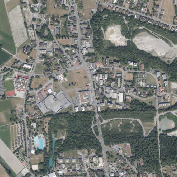
Orthophoto Liechtenstein 2018
Orthophoto with a resolution of 10 cm ground pixels. It was flown on 1/16 August and 11/20 September 2018 and is available in true colour (RGB). The entire country including the neighbouring region consists of 131 tiles of 2.5 x 2.0 km each or 25,000 x 20,000 pixels (500 Mpx). One tile has a size of 1.39 GB. In general, smaller or customised sections can also be ordered. Liechtenstein can be mapped with approx. 64 tiles.
Simple
- Date (Creation)
- 2019-03-20
- Identifier
- https://metadata.geo.llv.li/f004e045-50b3-42d5-bd46-d11451faf416
- Purpose
-
Basic data of the GDI-Liechtenstein
- Status
- Completed
Publisher
- Hours of service
-
8:00-11:30 und 13:30-17:00
- Spatial representation type
- Grid
Spatial resolution
- Spatial resolution
- 0.1 m
- Topic category
-
- A Imagery base maps earth cover
Extent
Extent
- Description
-
Liechtenstein
))

- Maintenance and update frequency
- Continual
Resource format
- Title
-
GeoTIFF (GEOTIFF)
- Date
- geocat.ch
-
-
digital color orthophoto mosaic
-
INSPIRE
-
orthophoto
-
OpenData
-
- GEMET - INSPIRE themes, version 1.0
-
-
Orthoimagery
-
- GEMET themes
-
-
research
-
- Räumlicher Anwendungsbereich
-
-
National
-
Resource constraints
- Access constraints
- Other restrictions
- Use constraints
- Other restrictions
- Other constraints
- No limitations to public access
Resource constraints
- Access constraints
- Other restrictions
- Use constraints
- Other restrictions
- Other constraints
- No conditions to access and use
- Other constraints
- Opendata BY: Open use. Must provide the source.
- Language
- Deutsch
- Character encoding
- UTF8
- Supplemental Information
-
Der Datensatz liegt in einzelnen Kacheln mit einer Grösse von 5 km2 vor
- Subtopic Category
- A1 Base Maps, Landscape Models
- Subtopic Category
- A3 Aerial and Satellite Imagery
- Attribute description
- RGB-Farbwert
- Distribution format
-
-
GeoTIFF (GEOTIFF)
-
Point of contact
- Hours of service
-
8:00-11:30 und 13:30-17:00
Digital transfer options
- Units of distribution
-
1 Kachel oder indiv. Ausschnitte
- OnLine resource
-
Homepage ATG, Datenausgabe
Data Distribution Office of Liechtensteinischen Landesverwaltung
Digital transfer options
- Units of distribution
-
1 Kachel oder indiv. Ausschnitte
- OnLine resource
-
Geodatenportal der Liechtensteinischen Landesverwaltung
Public online maps of the Liechtenstein National Administration
Digital transfer options
- Units of distribution
-
1 Kachel oder indiv. Ausschnitte
- OnLine resource
-
OI.OrthoimageCoverage2018
INSPIRE View Service
Digital transfer options
- Units of distribution
-
1 Kachel oder indiv. Ausschnitte
- OnLine resource
-
li.abi.orthophoto2018
OGC WMS Service der Liechtensteinen Landesverwaltung
Digital transfer options
- Units of distribution
-
1 Kachel oder indiv. Ausschnitte
- OnLine resource
-
Download als GeoTiff über das Geodatenportal
Download as GeoTiff via the geodata portal
- Hierarchy level
- Dataset
Report
Result
- Title
-
VERORDNUNG (EG) Nr. 1089/2010 DER KOMMISSION vom 23. November 2010 zur Durchführung der Richtlinie 2007/2/EG des Europäischen Parlaments und des Rates hinsichtlich der Interoperabilität von Geodatensätzen und -diensten
- Date (Publication)
- 2010-12-08
- Explanation
-
Gemäss INSPIRE Bestandteil des Themas Orthofotografie
- Pass
- false
- Statement
-
Luftbildbefliegung aus einer Flughöhe von ca. 2'200m? über Grund
- Hierarchy level
- Dataset
- Description
-
digitale Luftbilder
- Number of dimensions
- 2
- Cell geometry
- Area
- Transformation parameter availability
- 1
- Reference system identifier
- http://www.opengis.net/def/crs/EPSG/0/2056
- Reference system identifier
- http://www.opengis.net/def/crs/EPSG/0/4936
- Maintenance and update frequency
- As needed
Metadata
- Metadata identifier
- f004e045-50b3-42d5-bd46-d11451faf416
- Language
- Deutsch
- Character encoding
- UTF8
- Language
- Français
- Character encoding
- UTF8
- Language
- Italiano
- Character encoding
- UTF8
- Language
- English
- Character encoding
- UTF8
Point of contact
- Hours of service
-
8:00-11:30 und 13:30-17:00
Type of resource
- Resource scope
- Dataset
- Metadata linkage
-
https://www.geocat.ch/geonetwork/srv/api/records/f004e045-50b3-42d5-bd46-d11451faf416
- Date info (Creation)
- 2019-03-20T06:38:22Z
- Date info (Revision)
- 2026-04-13T09:46:10.661461Z
Metadata standard
- Title
-
eCH-0271