geocat.ch
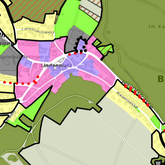
Zonenplan Bettingen
Zonenplan der Gemeinde Bettingen gemäss Beschluss der Einwohnergemeindeversammlung vom 2. Dezember 2008 und der Genehmigung des Bau- und Verkehrsdepartements vom 1.7.2009. Der Datensatz enthält den Zonenplan und die Bebauungspläne.
Simple
- Date (Creation)
- 2019-09-03
- Status
- Completed
Owner
- Spatial representation type
- Vector
- Topic category
-
- E Planning cadastre
Extent
Extent
- Description
-
Basel
))

Extent
Extent
- Description
-
Bettingen
))

- Maintenance and update frequency
- Continual
- GEMET
-
-
land use planning
-
- geocat.ch
-
-
land use planning
-
- GEMET
-
-
land use plan
-
- GEMET
-
-
allocation plan
-
- geocat.ch
-
-
land use plan
-
Resource constraints
- Other constraints
-
Die Geodaten sind öffentlich zugänglich. (Zugangsberechtigungsstufe [A] = öffentlich)
- Other constraints
-
Es gelten die Nutzungsbedingungen für Geodaten des Kantons Basel-Stadt. ( http://www.geo.bs.ch/agb)
- Language
- Deutsch
- Character encoding
- UTF8
- Subtopic Category
- E1 Spatial Planning, Spatial Development
- Basic Geodata
- true
- Basic Geodata ID
-
73>A
- Basic Geodata Legal Level
- Federal
- Distribution format
-
-
AutoCAD DXF (DXF)
-
AutoCAD DWG (DWG)
-
ESRI Shapefile (SHP)
-
OGC Geopackage (GPKG)
-
ESRI File Geodatabase FileGDB (GDB)
-
GeoJSON (GEOJSON)
-
TEXT, comma separated (CSV)
-
GeoParquet
-
FlatGeobuf
-
Distributor
- Hours of service
-
Mo - Do: 8:00 bis 12:00, 13:30 bis 16:30, Fr: 8:00 bis 12:00, 13:30 bis 16:00
Digital transfer options
- OnLine resource
-
MapBS
Öffentliches Auskunftssystem des Kantons Basel-Stadt
Digital transfer options
- OnLine resource
-
Geodaten-Shop
Öffentlich zugänglicher Geodaten-Downloaddienst des Kantons Basel-Stadt
Digital transfer options
- OnLine resource
-
WMS BS
Die derzeit im WMS BS verfügbaren Datenebenen entsprechen, bis auf wenige Ausnahmen, den Geodaten, welche auch in MapBS dargestellt sind. Der WMS BS ist kostenlos nutzbar und bietet Zugriff auf öffentliche sowie beschränkt öffentliche Geodaten, wobei gegebenenfalls Benutzername und Passwort benötigt werden (Zugangsdaten von MapBS).
Digital transfer options
- OnLine resource
-
WFS BS
Die derzeit im WFS BS verfügbaren Datenebenen entsprechen, bis auf wenige Ausnahmen, den Geodaten, welche auch in MapBS dargestellt sind. Der WFS BS ist kostenlos nutzbar und bietet Zugriff auf öffentliche sowie beschränkt öffentliche Geodaten, wobei gegebenenfalls Benutzername und Passwort benötigt werden (Zugangsdaten von MapBS).
- Reference system identifier
- CH1903+ / LV95/EPSG: 2056
Metadata
- Metadata identifier
- eb2f5688-0a3e-4e24-a917-e1f56d548ed1
- Language
- Deutsch
- Character encoding
- UTF8
- Language
- Français
- Character encoding
- UTF8
- Language
- Italiano
- Character encoding
- UTF8
- Language
- English
- Character encoding
- UTF8
Custodian
Type of resource
- Resource scope
- Dataset
- Metadata linkage
-
https://www.geocat.ch/geonetwork/srv/api/records/eb2f5688-0a3e-4e24-a917-e1f56d548ed1
- Date info (Creation)
- 2019-08-21T07:52:34Z
- Date info (Revision)
- 2026-04-13T09:18:11.986963Z
Metadata standard
- Title
-
eCH-0271