geocat.ch
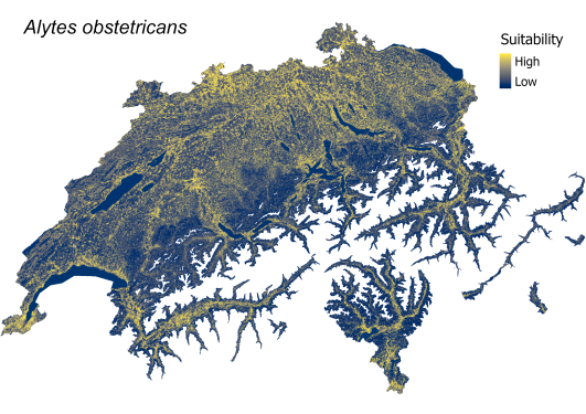
Terrestrial habitat suitability for amphibians
Maps of Switzerland showing the suitability of terrestrial habitat for 11 amphibian species at a resolution of one hectare. Each grid cell indicates the relative suitability (on a continuous scale from 0 to 1) of the landscape as a habitat for the terrestrial stage of the species. Suitability increases from blue (low suitability) to yellow (high suitability). The suitability of the terrestrial habitat was determined solely on the basis of the environmental characteristics of the landscape element on the respective hectare grid and does not take into account the actual current occurrence of the respective species (i.e. a suitable terrestrial habitat can exist well outside a species' existing natural range, and a species can also occur at a site with low modeled suitability of the terrestrial habitat within its natural range).
The suitability map of each species is the result of the best-rated 'Species Distribution Model'. The model was fitted to the data using the R-package BioMod2 and describes the relationship between the recorded terrestrial occurrences of a species and 22 explanatory environmental variables, which were assessed on five scales. (e.g. sea level, moisture potential, proportion of forest, standing water, etc).
Further details in the attached data description.
Literature:
Churko G., Szerencsits E., Aldrich A., Schmidt B. R. (2024). Spatial analysis of the potential exposure of amphibians to plant protection products at the landscape scale. Basic and Applied Ecology, 76, 14-24. https://doi.org/10.1016/j.baae.2024.02.004
Simple
- Date (Publication)
- 2024-02-23
- Identifier
- ETL01
- Status
- Completed
Point of contact
Author
Principal investigator
- Spatial representation type
- Grid
Spatial resolution
- Spatial resolution
- 100 m
Extent
Extent
- Description
-
Switzerland
))

- Maintenance and update frequency
- Not planned
Resource format
- Title
-
Tagged Image File Format (TIFF)
- Date
Resource format
- Title
-
Cloud Optimized GeoTIFF (TIFF / TIF)
- Date
- Edition
-
-
- geocat.ch
-
-
confederation
-
opendata.swiss
-
- GEMET themes
-
-
agriculture
-
natural areas, landscape, ecosystems
-
- GEMET
-
-
agriculture
-
amphibian
-
nature conservation
-
fauna
-
Resource constraints
Associated resource
- Association Type
- Reference to a master resource of which this one is a part
- Metadata Reference
Associated resource
- Association Type
- Reference to a master resource of which this one is a part
- Metadata Reference
Associated resource
- Association Type
- Reference to a master resource of which this one is a part
- Metadata Reference
Associated resource
- Association Type
- Reference to a master resource of which this one is a part
- Metadata Reference
Associated resource
- Association Type
- Reference to a master resource of which this one is a part
- Metadata Reference
Associated resource
- Association Type
- Reference to a master resource of which this one is a part
- Metadata Reference
Associated resource
- Association Type
- Reference to a master resource of which this one is a part
- Metadata Reference
Associated resource
- Association Type
- Reference to a master resource of which this one is a part
- Metadata Reference
Associated resource
- Association Type
- Reference to a master resource of which this one is a part
- Metadata Reference
Associated resource
- Association Type
- Reference to a master resource of which this one is a part
- Metadata Reference
Associated resource
- Association Type
- Reference to a master resource of which this one is a part
- Metadata Reference
Associated resource
- Association Type
- Reference to a master resource of which this one is a part
- Metadata Reference
Associated resource
- Association Type
- Reference to a master resource of which this one is a part
- Metadata Reference
- Language
- Deutsch
- Character encoding
- UTF8
- Subtopic Category
- L2 Nature and Landscape Protection
- Basic Geodata
- false
- Basic Geodata Legal Level
- Federal
- Basic Geodata Type
- openData
- Distribution format
-
-
Cloud Optimized GeoTIFF (TIFF / TIF)
-
Owner
Distributor
Digital transfer options
- OnLine resource
-
Datenbeschreibung_AmphibienAckerland.pdf
Digital transfer options
- OnLine resource
-
DescriptionDonnees_BatrachiensAgricole.pdf
- Geometric object type
- Surface
- Reference system identifier
- LV95 EPSG:2056
- Maintenance and update frequency
- As needed
Metadata
- Metadata identifier
- e2659ef0-2031-4793-9d88-95a94cacd2af
- Language
- Deutsch
- Character encoding
- UTF8
- Language
- Français
- Character encoding
- UTF8
- Language
- Italiano
- Character encoding
- UTF8
- Language
- English
- Character encoding
- UTF8
- Language
- Rumantsch
- Character encoding
- UTF8
Owner
Point of contact
Type of resource
- Resource scope
- Dataset
- Metadata linkage
-
https://www.geocat.ch/geonetwork/srv/api/records/e2659ef0-2031-4793-9d88-95a94cacd2af
- Date info (Creation)
- 2024-03-18T14:41:32.689Z
- Date info (Revision)
- 2026-06-15T07:21:07.264172Z
Metadata standard
- Title
-
eCH-0271