geocat.ch
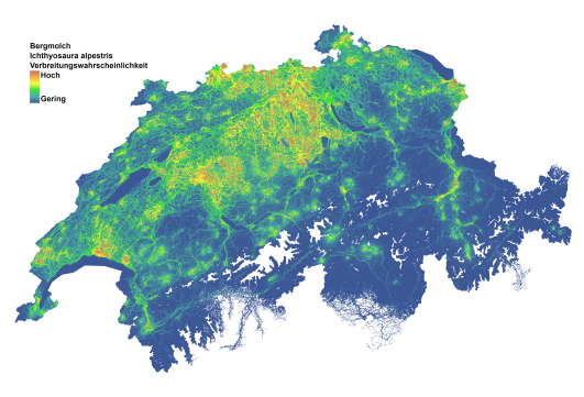
Amphibian dispersal maps - Ichthyosaura alpestris
Swiss-wide map depicting the dispersal probability of the Alpine newt (Ichthyosaura alpestris). Each grid cell indicates the relative probability that dispersing individuals will pass through that hectare on their way between known amphibian breeding sites. The map shows dispersal probability increasing along a scale from blue to yellow to red.
These maps should be thought of as heatmaps for dispersal activity of existing populations. In practical terms, these maps also show locations where potential new amphibian breeding sites have the highest chances of being colonized.
Areas with many populations in close proximity appear a darker red, reflecting the higher probability of dispersal as multiple dispersal routes between populations intersect. This feature of the maps deserves special attention. Lighter shades at the edges of the species' range do not necessarily indicate a weaker connection between populations, but rather a consequence of the lower density of breeding sites at the edges of the range. The color scale should be considered in the context of the immediate surroundings.
The dispersal map was calculated using Circuitscape and is based on a landscape resistance matrix derived from the best-ranked dispersal model for each species.
For details, see the attached data description.
Literature:
Swiss-wide map depicting the dispersal probability of the Smooth newt (Lissotriton vulgaris). Each grid cell indicates the relative probability that dispersing individuals will pass through that hectare on their way between known amphibian breeding sites. The map shows dispersal probability increasing along a scale from blue to yellow to red.
These maps should be thought of as heatmaps for dispersal activity of existing populations. In practical terms, these maps also show locations where potential new amphibian breeding sites have the highest chances of being colonized.
Areas with many populations in close proximity appear a darker red, reflecting the higher probability of dispersal as multiple dispersal routes between populations intersect. This feature of the maps deserves special attention. Lighter shades at the edges of the species' range do not necessarily indicate a weaker connection between populations, but rather a consequence of the lower density of breeding sites at the edges of the range. The color scale should be considered in the context of the immediate surroundings.
The dispersal map was calculated using Circuitscape and is based on a landscape resistance matrix derived from the best-ranked dispersal model for each species.
For details, see the attached data description.
Literature:
Churko G., Szerencsits E., Aldrich A., Schmidt B. R. (2024). Spatial analysis of the potential exposure of amphibians to plant protection products at the landscape scale. Basic and Applied Ecology, 76, 14-24. https://doi.org/10.1016/j.baae.2024.02.004
Simple
- Date (Publication)
- 2024-02-23
- Identifier
- ADN06
- Status
- Completed
Author
Principal investigator
Point of contact
- Spatial representation type
- Grid
Spatial resolution
- Spatial resolution
- 100 m
- Topic category
-
- G Biota
- L Environment
- S Farming
Extent
Extent
- Description
-
Switzerland
))

- Maintenance and update frequency
- Not planned
Resource format
- Title
-
Tagged Image File Format (TIFF)
- Date
Resource format
- Title
-
Cloud Optimized GeoTIFF (TIFF / TIF)
- Date
- Edition
-
-
- geocat.ch
-
-
confederation
-
opendata.swiss
-
- GEMET themes
-
-
natural areas, landscape, ecosystems
-
agriculture
-
- GEMET
-
-
agriculture
-
amphibian
-
fauna
-
nature conservation
-
Resource constraints
- Access constraints
- Copyright
- Use constraints
- Copyright
- Other constraints
- Opendata OPEN: Open use.
- Other constraints
-
CC-Lizenz?
- Language
- Deutsch
- Character encoding
- UTF8
- Subtopic Category
- L2 Nature and Landscape Protection
- Basic Geodata
- false
- Basic Geodata Legal Level
- Federal
- Basic Geodata Type
- openData
- Distribution format
-
-
Cloud Optimized GeoTIFF (TIFF / TIF)
-
Owner
Distributor
Digital transfer options
- OnLine resource
-
Datenbeschreibung_AmphibienAckerland.pdf
Digital transfer options
- OnLine resource
-
DescriptionDonnees_BatrachiensAgricole.pdf
- Geometric object type
- Surface
- Reference system identifier
- LV95 EPSG:2056
- Maintenance and update frequency
- As needed
Metadata
- Metadata identifier
- 9ea54bf1-43b5-4cbd-ab46-0a9dd65567ce
- Language
- Deutsch
- Character encoding
- UTF8
- Language
- English
- Character encoding
- UTF8
- Language
- Français
- Character encoding
- UTF8
- Language
- Italiano
- Character encoding
- UTF8
- Language
- Rumantsch
- Character encoding
- UTF8
Owner
Type of resource
- Resource scope
- Dataset
- Metadata linkage
-
https://www.geocat.ch/geonetwork/srv/api/records/9ea54bf1-43b5-4cbd-ab46-0a9dd65567ce
- Date info (Creation)
- 2024-03-18T14:01:46.618Z
- Date info (Revision)
- 2026-04-13T09:17:30.181694Z
Metadata standard
- Title
-
eCH-0271