geocat.ch
Eignung des Landlebensraums für Amphibien
Qualité potentielle de l'habitat terrestre aux amphibiens
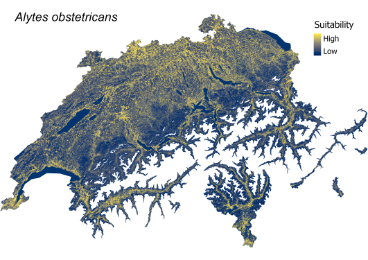
Terrestrial habitat suitability for amphibians
Schweizweite Karten, die die Eignung des terrestrischen Lebensraums für 11 Amphibienarten in Hektarauflösung darstellen. Jede Rasterzelle gibt die relative Eignung (auf einer kontinuierlichen Skala von 0 bis 1) der Landschaft als Lebensraum für das terrestrische Stadium der Art an. Die Eignung steigt von Blau (geringe Eignung) bis Gelb (hohe Eignung). Die Eignung des Landlebensraum wurde einzig auf der Basis der Umweltmerkmale des Landschaftselements auf dem jeweiligen Hektarraster bestimmt und berücksichtigt das tatsächliche aktuelle Vorkommen der jeweiligen Art nicht (d. h. ein geeigneter terrestrischer Lebensraum kann weit ausserhalb des bestehenden natürlichen Verbreitungsgebiets einer Art existieren und innerhalb des natürlichen Verbreitungsgebiets kann eine Art auch an einem Ort mit geringer modellierter Eignung des Landlebensraumes vorkommen).
Die Eignungskarte jeder Art ist das Ergebnis des am besten bewerteten «Species Distribution Model». Das Modell wurde mit dem R-Paket BioMod2 an die Daten angepasst und beschreibt die Beziehung zwischen den aufgezeichneten terrestrischen Vorkommen einer Art und 22 erklärenden Umweltvariablen, die auf fünf Skalen bewertet wurden. (z.B. Meereshöhe, Feucht-Potenzial, Anteil von Wald, Stillgewässer, etc).
Weitere Details in der beigefügten Datenbeschreibung.
Literatur:
Churko G., Szerencsits E., Aldrich A., Schmidt B. R. (2024). Spatial analysis of the potential exposure of amphibians to plant protection products at the landscape scale. Basic and Applied Ecology, 76, 14-24. https://doi.org/10.1016/j.baae.2024.02.004
Cartes à l'échelle de la Suisse représentant la qualité potentielle de l'habitat terrestre pour 11 espèces d'amphibiens avec une résolution à l'hectare. Chaque cellule de la grille indique la qualité potentielle (sur une échelle continue de 0 à 1) du paysage comme habitat pour le stade terrestre de l'espèce. La qualité augmente du bleu (faible qualité) au jaune (qualité élevée). La qualité de l'habitat terrestre a été déterminée uniquement sur la base des caractéristiques environnementales d'un hectare donné et ne tient pas compte de la présence effective actuelle de l'espèce concernée (c'est-à-dire qu'un habitat terrestre approprié peut exister bien en dehors de l'aire de répartition naturelle existante d'une espèce et qu'à l'intérieur de l'aire de répartition naturelle, une espèce peut également être présente dans un endroit où la qualité potentielle de l'habitat terrestre modélisée est faible).
La carte d'aptitude de chaque espèce est le résultat du "Species Distribution Model" le mieux évalué. Ce modèle a été adapté aux données à l'aide du package R BioMod2 et décrit la relation entre les occurrences terrestres enregistrées d'une espèce et 22 variables environnementales explicatives, évaluées sur cinq échelles. (p. ex. altitude, humidité potentielle, proportion de forêts, d'eaux calmes, etc.
Litérature:
Literature:
Churko G., Szerencsits E., Aldrich A., Schmidt B. R. (2024). Spatial analysis of the potential exposure of amphibians to plant protection products at the landscape scale. Basic and Applied Ecology, 76, 14-24. https://doi.org/10.1016/j.baae.2024.02.004
Plus de détails dans la description des données ci-jointe.
Maps of Switzerland showing the suitability of terrestrial habitat for 11 amphibian species at a resolution of one hectare. Each grid cell indicates the relative suitability (on a continuous scale from 0 to 1) of the landscape as a habitat for the terrestrial stage of the species. Suitability increases from blue (low suitability) to yellow (high suitability). The suitability of the terrestrial habitat was determined solely on the basis of the environmental characteristics of the landscape element on the respective hectare grid and does not take into account the actual current occurrence of the respective species (i.e. a suitable terrestrial habitat can exist well outside a species' existing natural range, and a species can also occur at a site with low modeled suitability of the terrestrial habitat within its natural range).
The suitability map of each species is the result of the best-rated 'Species Distribution Model'. The model was fitted to the data using the R-package BioMod2 and describes the relationship between the recorded terrestrial occurrences of a species and 22 explanatory environmental variables, which were assessed on five scales. (e.g. sea level, moisture potential, proportion of forest, standing water, etc).
Further details in the attached data description.
Literature:
Churko G., Szerencsits E., Aldrich A., Schmidt B. R. (2024). Spatial analysis of the potential exposure of amphibians to plant protection products at the landscape scale. Basic and Applied Ecology, 76, 14-24. https://doi.org/10.1016/j.baae.2024.02.004
Simple
-
Date (Publication)Data (Pubblicazione)Date (Publication)Date (Publication)Datum (Publikation)
- 2024-02-23
-
IdentifiantIdentificatoreIdentifierIdentifierKennung
- ETL01
-
ÉtatStatoStatusStatusBearbeitungsstatus
-
TerminéCompletatoCompletedCompletedAbgeschlossen
Point de contact
Punto di contatto
Point of contact
Point of contact
Ansprechpartner
Auteur
Autore
Author
Author
Autor
Auteur principal de la recherche
Ricercatore principale
Principal investigator
Principal investigator
Projektleiter
-
Type de représentation spatialeTipo di rappresentazione spazialeSpatial representation typeSpatial representation typeRäumliche Darstellungsart
-
grilleRasterGridGridRaster, Gitter
Résolution spatiale
Risoluzione spaziale
Spatial resolution
Spatial resolution
Räumliche Auflösung
-
Distance de résolutionDistanza di risoluzioneSpatial resolutionSpatial resolutionDistanz
- 100 m
Étendue
Estensione
Extent
Extent
Ausdehnung
Étendue
Estensione
Extent
Extent
Ausdehnung
-
DescriptionDescrizioneDescriptionDescriptionBeschreibung
-
Switzerland
Schweiz
Suisse
Svizzera
Svizra
))

-
Fréquence de mise à jourFrequenza di aggiornamentoMaintenance and update frequencyMaintenance and update frequencyWartungsintervall
-
Non planifiéeNon pianificatoNot plannedNot plannedNicht geplant
Format de la ressource
Formato della risorsa
Resource format
Resource format
Format der Ressource
-
TitreTitoloTitleTitleTitel
-
Tagged Image File Format (TIFF)
-
DateDataDateDateDatum
Format de la ressource
Formato della risorsa
Resource format
Resource format
Format der Ressource
-
TitreTitoloTitleTitleTitel
-
Cloud Optimized GeoTIFF (TIFF / TIF)
-
DateDataDateDateDatum
-
ÉditionEdizioneEditionEditionAusgabe
-
-
- geocat.ch
-
-
confédération
confederazione
confederation
-
opendata.swiss
opendata.swiss
opendata.swiss
opendata.swiss
-
- GEMET themes
-
-
agriculture
agricoltura
agriculture
-
zones naturelles, paysages, écosystèmes
aree naturali, paesaggio, ecosistemi
natural areas, landscape, ecosystems
-
- GEMET
-
-
agriculture
agricoltura
agriculture
-
batracien
anfibi
amphibian
-
préservation de la nature
conservazione della natura
nature conservation
-
faune
fauna
fauna
-
Contraintes sur la ressource
Vincoli sulle risorse
Resource constraints
Resource constraints
Ressourcenbeschränkungen
-
Contraintes d'accèsVincoli di accessoAccess constraintsAccess constraintsZugriffsbeschränkungen
-
Droit d’auteurCopyrightCopyrightCopyrightUrheberrecht
-
Contraintes d'utilisationVincoli d'usoUse constraintsUse constraintsNutzungseinschränkungen
-
Droit d’auteurCopyrightCopyrightCopyrightUrheberrecht
-
Autres contraintesAltri vincoliOther constraintsOther constraintsAndere Einschränkungen
- Opendata OPEN: Freie Nutzung.Opendata OPEN: Utilisation libre.Opendata OPEN: Libero utilizzo.Opendata OPEN: Open use.
Ressource associée
Risorsa associata
Associated resource
Associated resource
Verlinkte Ressource
-
Type d'associationTipo di associazioneAssociation TypeAssociation TypeAssoziationstyp
-
Citation de travail plus largeCitazione di un'opera più ampiaReference to a master resource of which this one is a partReference to a master resource of which this one is a partÜbergeordneter Datenbestand
-
Metadata ReferenceRiferimento metadatiMetadata ReferenceMetadata ReferenceMetadatenreferenz
-
LangueLinguaLanguageLanguageSprache
- Deutsch
-
Encodage de caractèresCodifica dei caratteriCharacter encodingCharacter encodingZeichenkodierung
-
Utf8UTF8UTF8UTF8Utf8
-
Catégorie de sous-thèmeCategoria di sottotemaSubtopic CategorySubtopic CategoryThematische Unterkategorien
-
L2 Protection de la nature et du paysageL2 Protezione della natura e del paesaggioL2 Nature and Landscape ProtectionL2 Nature and Landscape ProtectionL2 Natur- und Landschaftsschutz
-
Géodonnées de baseGeodati di baseBasic GeodataBasic GeodataGeobasisdaten
- false
-
Niveau des géodonnées de baseLivello legale dei geodati di baseBasic Geodata Legal LevelBasic Geodata Legal LevelGeobasisdatenebene
-
FédéralFederaleFederalFederalNational
-
Type de géodonnées de baseTipo di geodati di baseBasic Geodata TypeBasic Geodata TypeGeobasisdatentyp
-
openDataopenDataopenDataopenDataopenData
-
Format de distributionFormato (codifica)Distribution formatDistribution formatAbgabeformat
-
-
Cloud Optimized GeoTIFF (TIFF / TIF)
-
Propriétaire
Proprietario
Owner
Owner
Eigentümer
Distributeur
Distributore
Distributor
Distributor
Verteiler
Options de transfert numérique
Opzioni di trasferimento digitale
Digital transfer options
Digital transfer options
Optionen für die digitale Übertragung
-
Ressource en ligneRisorsa onlineOnLine resourceOnLine resourceOnline
-
Datenbeschreibung_AmphibienAckerland.pdf
Options de transfert numérique
Opzioni di trasferimento digitale
Digital transfer options
Digital transfer options
Optionen für die digitale Übertragung
-
Ressource en ligneRisorsa onlineOnLine resourceOnLine resourceOnline
-
DescriptionDonnees_BatrachiensAgricole.pdf
-
Type d’objet géométriqueTipo di oggetto geometricoGeometric object typeGeometric object typeTyp des geometrischen Objekts
-
PolygoneSuperficieSurfaceSurfacesurface
-
Nom du système de référenceNome del sistema di riferimentoReference system identifierReference system identifierName des Referenzsystems
- LV95 EPSG:2056
-
Fréquence de mise à jourFrequenza di aggiornamentoMaintenance and update frequencyMaintenance and update frequencyWartungsintervall
-
Comme nécessaireSecondo necessitàAs neededAs neededBei Bedarf
Metadata
-
Identifiant des métadonnéesIdentificativo della schedaMetadata identifierMetadata identifierIdentifikator des Metadatensatzes
- e2659ef0-2031-4793-9d88-95a94cacd2af
-
LangueLinguaLanguageLanguageSprache
- Deutsch
-
Encodage de caractèresCodifica dei caratteriCharacter encodingCharacter encodingZeichenkodierung
-
Utf8UTF8UTF8UTF8Utf8
-
LangueLinguaLanguageLanguageSprache
- Français
-
Encodage de caractèresCodifica dei caratteriCharacter encodingCharacter encodingZeichenkodierung
-
Utf8UTF8UTF8UTF8Utf8
-
LangueLinguaLanguageLanguageSprache
- Italiano
-
Encodage de caractèresCodifica dei caratteriCharacter encodingCharacter encodingZeichenkodierung
-
Utf8UTF8UTF8UTF8Utf8
-
LangueLinguaLanguageLanguageSprache
- English
-
Encodage de caractèresCodifica dei caratteriCharacter encodingCharacter encodingZeichenkodierung
-
Utf8UTF8UTF8UTF8Utf8
-
LangueLinguaLanguageLanguageSprache
- Rumantsch
-
Encodage de caractèresCodifica dei caratteriCharacter encodingCharacter encodingZeichenkodierung
-
Utf8UTF8UTF8UTF8Utf8
Propriétaire
Proprietario
Owner
Owner
Eigentümer
Point de contact
Punto di contatto
Point of contact
Point of contact
Ansprechpartner
Type de ressource
Tipo di risorsa
Type of resource
Type of resource
Anwendungsbereich der Metadaten
-
Domaine d'application de la ressourceAmbito di applicazione della risorsaResource scopeResource scopeDomäne der Ressourcenanwendung
-
Jeu de donnéesSet di datiDatasetDatasetDatenbestand
-
Lien vers la métadonnéeCollegamento ai metadatiMetadata linkageMetadata linkageLink zu den Metadaten
-
Informations de date (Création)Informazioni sulla data (Creazione)Date info (Creation)Date info (Creation)Datumsangaben (Erstellung)
- 2024-03-18T14:41:32.689Z
-
Informations de date (Révision)Informazioni sulla data (Revisione)Date info (Revision)Date info (Revision)Datumsangaben (Aktualisierung)
- 2026-06-15T07:21:07.264172Z
Norme des métadonnées
Standard dei metadati
Metadata standard
Metadata standard
Metadatenstandard
-
TitreTitoloTitleTitleTitel
-
eCH-0271