geocat.ch
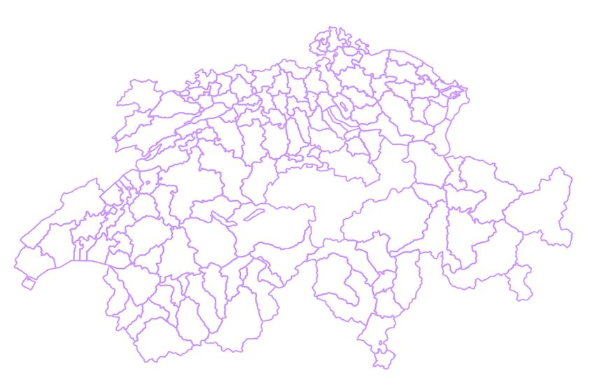
swissBOUNDARIES3D district boundaries
swissBOUNDARIES3D district boundaries constitute the administrative borders of the districts of the Swiss cantons. A district is an administrative subdivision positioned between canton and commune. The cantons of Geneva, Uri, Obwalden, Nidwalden, Glarus, Zug, Basel-Stadt and Appenzell Innerrhoden are not divided into districts. swissBOUNDARIES district boundaries is derived from the parent dataset swissBOUNDARIES3D.
Simple
- Alternate title
-
District boundaries
- Date (Revision)
- 2025-12-18
- Date (Publication)
- 2026-01-01
- Identifier
- ch.swisstopo.swissboundaries3d-bezirk-flaeche.fill
Point of contact
Spatial resolution
Equivalent scale
- Denominator
- 10000
- Topic category
-
- D Boundaries
Extent
Extent
- Description
-
Switzerland
))

Extent
Extent
- Description
-
Liechtenstein
))

- Maintenance and update frequency
- Annually
- Maintenance note
-
swissBOUNDARIES3D wird jährlich nachgeführt. Die aktuelle Version gibt den Zustand am 1. Januar des laufenden Jahres wieder. Die Nachführung erfolgt auf den Grundlagen der Amtlichen Vermessung (AV) und des Bundesamtes für Statistik (BFS).
- GEMET - INSPIRE themes, version 1.0
-
-
Administrative units
-
- geocat.ch
-
-
opendata.swiss
-
district
-
- geocat.ch
-
-
FSDI Federal Spatial Data Infrastructure
-
- GEMET
-
-
administrative boundary
-
Resource constraints
- Use constraints
- License
- Other constraints
-
NonCommercialAllowed-CommercialAllowed-ReferenceRequired
Associated resource
- Association Type
- Reference to a master resource of which this one is a part
- Metadata Reference
Associated resource
- Title
-
Administrative boundaries (national survey)
- Association Type
- Reference to a master resource of which this one is a part
- Language
- Deutsch
- Character encoding
- UTF8
- Language
- Français
- Character encoding
- UTF8
- Language
- English
- Character encoding
- UTF8
- Basic Geodata
- true
- Basic Geodata ID
-
39.3
- Basic Geodata Legal Level
- Federal
- Included with dataset
- 0
- Title
-
swissBOUNDARIES3D Grenzen Schweizweit in 3D
- Date (Publication)
- 2026-01-01
- Distribution format
-
-
ESRI Shapefile (SHP)
-
ESRI File Geodatabase FileGDB (GDB)
-
AutoCAD DXF (DXF)
-
INTERLIS 2 (XTF)
-
OGC Geopackage (GPKG)
-
Digital transfer options
- OnLine resource
-
Vorschau map.geo.admin.ch
Preview map.geo.admin.ch
Digital transfer options
- OnLine resource
-
Linked Data
Digital transfer options
- OnLine resource
-
ch.swisstopo.swissboundaries3d-bezirk-flaeche.fill
WMS-FSDI service, layer "District boundaries"
Digital transfer options
- OnLine resource
-
ch.swisstopo.swissboundaries3d-bezirk-flaeche.fill
WMTS-FSDI service, layer "District boundaries"
Digital transfer options
Digital transfer options
Digital transfer options
- OnLine resource
-
map.geo.admin.ch
Digital transfer options
- OnLine resource
-
RESTful API von geo.admin.ch
RESTful API from geo.admin.ch
Digital transfer options
- OnLine resource
-
Linked Data Dienst (via SPARQL)
- Geometric object type
- Curve
- Geometric object type
- Surface
- Reference system identifier
- EPSG:2056
Metadata
- Metadata identifier
- e1b8837d-8c19-4b65-a8b5-21aaff44fa91
- Language
- Deutsch
- Character encoding
- UTF8
- Language
- Français
- Character encoding
- UTF8
- Language
- Italiano
- Character encoding
- UTF8
- Language
- English
- Character encoding
- UTF8
- Language
- Rumantsch
- Character encoding
- UTF8
Point of contact
Type of resource
- Resource scope
- Dataset
- Metadata linkage
-
https://www.geocat.ch/geonetwork/srv/api/records/e1b8837d-8c19-4b65-a8b5-21aaff44fa91
- Date info (Creation)
- 2011-10-24T08:51:30Z
- Date info (Revision)
- 2026-04-13T09:16:41.738888Z
Metadata standard
- Title
-
eCH-0271