geocat.ch
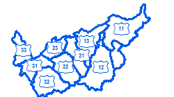
Secteurs de construction et d'entretien routier, subdivision d'un arrondissement
Découpage du territoire en 9 secteurs de construction et d'entretien routier : Secteur 11+12+13, Haut-Valais; Secteur 21+22+23, Valais central; Secteur 31+32+33, Bas-Valais
Simple
- Alternate title
-
Secteurs
- Date (Creation)
- 1990-01-01
- Date (Revision)
- 2026-03-12
- Identifier
- 375
- Purpose
-
Gestion des travaux de construction et d'entretien
- Status
- On going
Custodian
- Spatial representation type
- Vector
Spatial resolution
Equivalent scale
- Denominator
- 10000
- Topic category
-
- P Transportation
Extent
Extent
- Description
-
Canton of Valais (VS)
))

- Maintenance and update frequency
- Annually
Resource format
- Title
-
ESRI Enterprise Geodatabase
- Date
- GEMET - INSPIRE themes, version 1.0
-
-
Area management/restriction/regulation zones and reporting units
-
- GEMET
-
-
road maintenance
-
Resource constraints
- Use limitation
-
Aucune
Resource constraints
- Access constraints
- Other restrictions
- Other constraints
-
Géodonnées non accessibles au public (niveau C selon l'OGéo)
- Other constraints
-
Les conditions générales d'utilisation des géodonnées du Canton du Valais font foi ( https://www.vs.ch/fr/web/guest/information-legale).
- Language
- Français
- Character encoding
- UTF8
- Language
- Deutsch
- Character encoding
- UTF8
- Environment description
-
S:\Géodonnées VS\P Transport\Secteurs.lyr
- Included with dataset
- 0
- Title
-
Structure - Secteurs
- Date (Creation)
- 2016-06-20
- Distribution format
-
-
ESRI Shapefile (SHP)
-
autres formats sur demande / andere Formate auf Anfrage
-
Distributor
- Statement
-
Organisation interne du SDM
- Hierarchy level
- Dataset
- Description
-
Agrégation de la surface des communes
- Geometric object type
- Surface
- Geometric object count
- 10
- Reference system identifier
- EPSG:2056/CH1903+_MN95
Metadata
- Metadata identifier
- d787e301-3efb-49a6-b308-2a4727661d65
- Language
- Français
- Character encoding
- UTF8
- Language
- Deutsch
- Character encoding
- UTF8
- Language
- Italiano
- Character encoding
- UTF8
- Language
- English
- Character encoding
- UTF8
- Language
- Rumantsch
- Character encoding
- UTF8
Distributor
Type of resource
- Resource scope
- Dataset
- Metadata linkage
-
https://www.geocat.ch/geonetwork/srv/api/records/d787e301-3efb-49a6-b308-2a4727661d65
- Date info (Creation)
- 2017-05-23T10:34:23Z
- Date info (Revision)
- 2026-04-13T09:34:17.846089Z
Metadata standard
- Title
-
eCH-0271