geocat.ch
Arbeitsmarktregionen und Arbeitsmarktgrossregionen
Bassins d’emploi et grands bassins d’emploi
Bacini d’impiego et grande bacini d'impiego
Labour market areas and large labour market areas
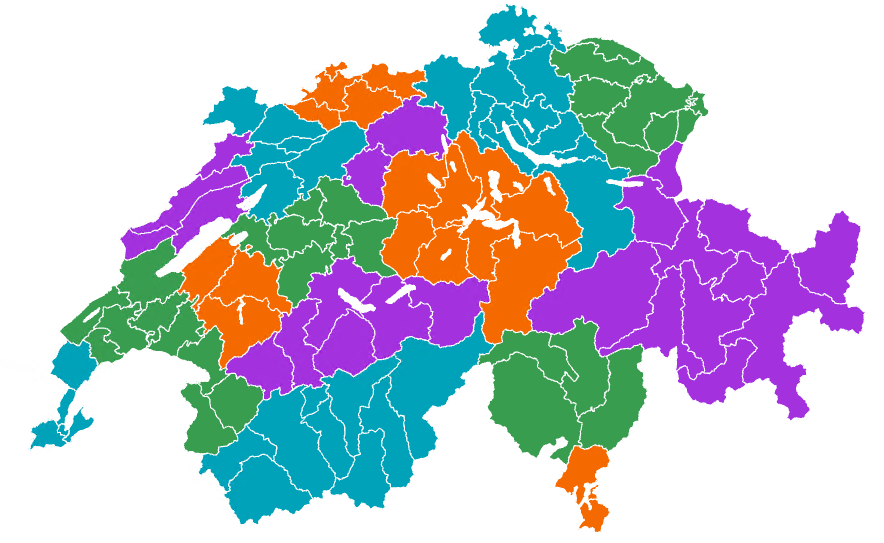
Arbeitsmarktregionen und Arbeitsmarktgrossregionen sind Gebiete, in denen die Mehrheit der Erwerbstätigen wohnt und arbeitet. Die beiden Räume unterscheiden sich in ihrer Grösse: Arbeitsmarktregionen sind relativ klein, Arbeitsmarktgrossregionen deutlich grösser. Diese und viele weitere räumliche Gliederungen wie Sprachregionen, Berggebiete oder Grossregionen werden in zwei Generalisierungsstufen angeboten. Die Vektordaten eignen sich zur Erstellung thematischer Karten und zur Analyse regionaler Entwicklungen und Trends im Zeitverlauf.
Les bassins d’emploi et les grands bassins d’emploi sont des territoires dans lesquels la majorité des personnes actives employées habitent et travaillent. Les deux niveaux se distinguent par leur taille, les grands bassins d'emploi étant beaucoup plus étendus que les bassins d’emploi. Ces niveaux géographiques, tout comme les régions linguistiques, les régions de montagne ou encore les grandes régions, sont proposés selon deux niveaux de généralisation. Les données vectorielles permettent de réaliser des cartes thématiques et d'analyser les évolutions et les tendances régionales au fil du temps.
Labor market regions and large labor market regions are areas in which the majority of the working population lives and works. The two areas differ in size: labor market regions are relatively small, while large labor market regions are significantly larger. These and many other spatial divisions such as language regions, mountain regions or major regions are offered in two levels of generalization. The vector data is suitable for creating thematic maps and for analyzing regional developments and trends over time.
Simple
-
Autre titreAltri nomi o acronimiAlternate titleAlternate titleAlternativtitel
-
Arbeitsmarktregionen und Arbeitsmarktgrossregionen
Bassins d’emploi et grands bassins d’emploi
Bacini d’impiego et grande bacini d'impiego
Labour market areas and large labour market areas
-
Date (Publication)Data (Pubblicazione)Date (Publication)Date (Publication)Datum (Publikation)
- 2025-07-02
-
IdentifiantIdentificatoreIdentifierIdentifierKennung
- ch.bfs.arbeitsmarktregionen
-
ÉtatStatoStatusStatusBearbeitungsstatus
-
ContinuIn corsoOn goingOn goingKontinuierliche Aktualisierung
Point de contact
Punto di contatto
Point of contact
Point of contact
Ansprechpartner
-
Catégorie de thèmeCategoria ISOTopic categoryTopic categoryThematik
-
-
D LimitesD ConfiniD BoundariesD BoundariesD Grenzen
-
Étendue
Estensione
Extent
Extent
Ausdehnung
Étendue
Estensione
Extent
Extent
Ausdehnung
-
DescriptionDescrizioneDescriptionDescriptionBeschreibung
-
Switzerland
Schweiz
Suisse
Svizzera
Svizra
))

-
Fréquence de mise à jourFrequenza di aggiornamentoMaintenance and update frequencyMaintenance and update frequencyWartungsintervall
-
AnnuelleAnnualmenteAnnuallyAnnuallyJährlich
-
Durée de conservationDurata di conservazioneDuration of ConservationDuration of ConservationAufbewahrungsdauer NV in Jahren
- 100
-
Évaluation de la valeur archivistiqueValutazione del valore archivisticoAppraisal of Archival ValueAppraisal of Archival ValueBewertung Archivwürdigkeit
-
AAAAA
Format de la ressource
Formato della risorsa
Resource format
Resource format
Format der Ressource
-
TitreTitoloTitleTitleTitel
-
OGC Geopackage (GPKG)
-
DateDataDateDateDatum
Format de la ressource
Formato della risorsa
Resource format
Resource format
Format der Ressource
-
TitreTitoloTitleTitleTitel
-
ESRI Shapefile (SHP)
-
DateDataDateDateDatum
Format de la ressource
Formato della risorsa
Resource format
Resource format
Format der Ressource
-
TitreTitoloTitleTitleTitel
-
GeoJSON (GEOJSON)
-
DateDataDateDateDatum
- Keywords
-
-
Statistik; Raumgliederungen
statistique; niveaux géographiques
livelli geografici
geographical levels
-
- Art des Geodatendienstes
-
-
Service de téléchargement
Servizio di scaricamento
Download Service
-
- geocat.ch
-
-
ligne de frontières
linea di confine
boundary line
-
opendata.swiss
opendata.swiss
opendata.swiss
opendata.swiss
-
IFDG l’Infrastructure Fédérale de données géographiques
IFDG Infrastruttura federale dei dati geografici
FSDI Federal Spatial Data Infrastructure
-
Utilisation spécifique de la ressource
Utilizzo specifico della risorsa
Resource specific usage
Resource specific usage
Spezifische Verwendung der Ressource
-
UtilisationUtilizzoSpecific usageSpecific usageVerwendung
-
Die Vektordaten eignen sich zur Erstellung thematischer Karten und zur Analyse regionaler Entwicklungen und Trends im Zeitverlauf.
Les données vectorielles sont adaptées à la création de cartes thématiques et à l'analyse des développements et tendances régionaux au fil du temps.
Vector data is suitable for creating thematic maps and analysing regional developments and trends over time.
Contraintes sur la ressource
Vincoli sulle risorse
Resource constraints
Resource constraints
Ressourcenbeschränkungen
-
Contraintes d'utilisationVincoli d'usoUse constraintsUse constraintsNutzungseinschränkungen
-
Autres restrictionsAltre restrizioniOther restrictionsOther restrictionsAndere Beschränkungen
-
Autres contraintesAltri vincoliOther constraintsOther constraintsAndere Einschränkungen
- Opendata BY ASK: Freie Nutzung. Quellenangabe ist Pflicht. Kommerzielle Nutzung nur mit Bewilligung des Datenlieferanten zulässig.Opendata BY ASK: Utilisation libre. Obligation d’indiquer la source. Utilisation commerciale uniquement avec l’autorisation du fournisseur des données.Opendata BY ASK: Libero utilizzo. Indicazione della fonte obbligatoria. Utilizzo a fini commerciali ammesso soltanto previo consenso del titolare dei dati.Opendata BY ASK: Open use. Must provide the source. Use for commercial purposes requires permission of the data owner.
-
LangueLinguaLanguageLanguageSprache
- Deutsch
-
Encodage de caractèresCodifica dei caratteriCharacter encodingCharacter encodingZeichenkodierung
-
Utf8UTF8UTF8UTF8Utf8
-
Géodonnées de baseGeodati di baseBasic GeodataBasic GeodataGeobasisdaten
- false
-
Niveau des géodonnées de baseLivello legale dei geodati di baseBasic Geodata Legal LevelBasic Geodata Legal LevelGeobasisdatenebene
-
FédéralFederaleFederalFederalNational
-
Format de distributionFormato (codifica)Distribution formatDistribution formatAbgabeformat
-
-
OGC Geopackage (GPKG)
-
ESRI Shapefile (SHP)
-
GeoJSON (GEOJSON)
-
Options de transfert numérique
Opzioni di trasferimento digitale
Digital transfer options
Digital transfer options
Optionen für die digitale Übertragung
-
Ressource en ligneRisorsa onlineOnLine resourceOnLine resourceOnline
-
Datenbeschreibung
Options de transfert numérique
Opzioni di trasferimento digitale
Digital transfer options
Digital transfer options
Optionen für die digitale Übertragung
-
Ressource en ligneRisorsa onlineOnLine resourceOnLine resourceOnline
-
GEOSTAT
GEOSTAT ist das BFS-Kompetenzzentrum für Geoinformation und digitale Bildverarbeitung.GEOSTAT est le centre de compétence pour la géoinformation et le traitement numérique des images digitales de l'OFS.
Options de transfert numérique
Opzioni di trasferimento digitale
Digital transfer options
Digital transfer options
Optionen für die digitale Übertragung
-
Ressource en ligneRisorsa onlineOnLine resourceOnLine resourceOnline
-
Visualisierung und Download
Options de transfert numérique
Opzioni di trasferimento digitale
Digital transfer options
Digital transfer options
Optionen für die digitale Übertragung
-
Ressource en ligneRisorsa onlineOnLine resourceOnLine resourceOnline
-
ch.bfs.arbeitsmarktregionen
WMS-BGDI Dienst, Layer "Arbeitsmarktregionen und Arbeitsmarktgrossregionen"Service WMS-IFDG, couche "Bassins d`emploi et grands bassins d`emploi"Servizio WMS-IFDG, strato "Bacini d`impiego et grande bacini d`impiego"WMS-FSDI service, layer "Labour market areas and large labour market areas"WMS-BGDI Dienst, Layer "Arbeitsmarktregionen und Arbeitsmarktgrossregionen"
Options de transfert numérique
Opzioni di trasferimento digitale
Digital transfer options
Digital transfer options
Optionen für die digitale Übertragung
-
Ressource en ligneRisorsa onlineOnLine resourceOnLine resourceOnline
-
ch.bfs.arbeitsmarktregionen
WMTS-BGDI Dienst, Layer "Arbeitsmarktregionen und Arbeitsmarktgrossregionen"Service WMTS-IFDG, couche "Bassins d'emploi et grands bassins d'emploi"Servizio WMTS-IFDG, strato "Bacini d'impiego et grande bacini d'impiego"WMTS-FSDI service, layer "Labour market areas and large labour market areas"WMTS-BGDI Dienst, Layer "Arbeitsmarktregionen und Arbeitsmarktgrossregionen"
Options de transfert numérique
Opzioni di trasferimento digitale
Digital transfer options
Digital transfer options
Optionen für die digitale Übertragung
-
Ressource en ligneRisorsa onlineOnLine resourceOnLine resourceOnline
-
RESTful API von geo.admin.ch
Options de transfert numérique
Opzioni di trasferimento digitale
Digital transfer options
Digital transfer options
Optionen für die digitale Übertragung
-
Ressource en ligneRisorsa onlineOnLine resourceOnLine resourceOnline
-
Vorschau map.geo.admin.ch
Options de transfert numérique
Opzioni di trasferimento digitale
Digital transfer options
Digital transfer options
Optionen für die digitale Übertragung
-
Ressource en ligneRisorsa onlineOnLine resourceOnLine resourceOnline
-
Variablenliste
I14Y-InteroperabilitätsplattformI14Y Plateforme d’interopérabilitéI14Y Piattaforma di interoperabilitàI14Y Interoperability platform
-
Nom du système de référenceNome del sistema di riferimentoReference system identifierReference system identifierName des Referenzsystems
- EPSG: 2056
Metadata
-
Identifiant des métadonnéesIdentificativo della schedaMetadata identifierMetadata identifierIdentifikator des Metadatensatzes
- d4ecc043-a230-4b74-a725-7f63fa2a0419
-
LangueLinguaLanguageLanguageSprache
- Deutsch
-
Encodage de caractèresCodifica dei caratteriCharacter encodingCharacter encodingZeichenkodierung
-
Utf8UTF8UTF8UTF8Utf8
-
LangueLinguaLanguageLanguageSprache
- Français
-
Encodage de caractèresCodifica dei caratteriCharacter encodingCharacter encodingZeichenkodierung
-
Utf8UTF8UTF8UTF8Utf8
-
LangueLinguaLanguageLanguageSprache
- Italiano
-
Encodage de caractèresCodifica dei caratteriCharacter encodingCharacter encodingZeichenkodierung
-
Utf8UTF8UTF8UTF8Utf8
-
LangueLinguaLanguageLanguageSprache
- English
-
Encodage de caractèresCodifica dei caratteriCharacter encodingCharacter encodingZeichenkodierung
-
Utf8UTF8UTF8UTF8Utf8
-
LangueLinguaLanguageLanguageSprache
- Rumantsch
-
Encodage de caractèresCodifica dei caratteriCharacter encodingCharacter encodingZeichenkodierung
-
Utf8UTF8UTF8UTF8Utf8
Dépositaire
Custode
Custodian
Custodian
Verwalter
-
Lien vers la métadonnéeCollegamento ai metadatiMetadata linkageMetadata linkageLink zu den Metadaten
-
Informations de date (Création)Informazioni sulla data (Creazione)Date info (Creation)Date info (Creation)Datumsangaben (Erstellung)
- 2025-04-14T13:43:42.07Z
-
Informations de date (Révision)Informazioni sulla data (Revisione)Date info (Revision)Date info (Revision)Datumsangaben (Aktualisierung)
- 2026-06-15T08:46:04.319778Z
Norme des métadonnées
Standard dei metadati
Metadata standard
Metadata standard
Metadatenstandard
-
TitreTitoloTitleTitleTitel
-
eCH-0271