geocat.ch
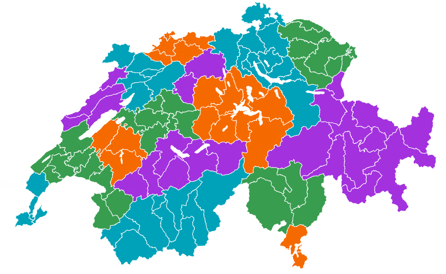
Labour market areas and large labour market areas
Labor market regions and large labor market regions are areas in which the majority of the working population lives and works. The two areas differ in size: labor market regions are relatively small, while large labor market regions are significantly larger. These and many other spatial divisions such as language regions, mountain regions or major regions are offered in two levels of generalization. The vector data is suitable for creating thematic maps and for analyzing regional developments and trends over time.
Simple
- Alternate title
-
Labour market areas and large labour market areas
- Date (Publication)
- 2025-07-02
- Identifier
- ch.bfs.arbeitsmarktregionen
- Status
- On going
Point of contact
- Topic category
-
- D Boundaries
Extent
Extent
- Description
-
Switzerland
))

- Maintenance and update frequency
- Annually
- Duration of Conservation
- 100
- Appraisal of Archival Value
- A
Resource format
- Title
-
OGC Geopackage (GPKG)
- Date
Resource format
- Title
-
ESRI Shapefile (SHP)
- Date
Resource format
- Title
-
GeoJSON (GEOJSON)
- Date
- Keywords
-
-
geographical levels
-
- Art des Geodatendienstes
-
-
Download Service
-
- geocat.ch
-
-
boundary line
-
opendata.swiss
-
FSDI Federal Spatial Data Infrastructure
-
Resource specific usage
- Specific usage
-
Vector data is suitable for creating thematic maps and analysing regional developments and trends over time.
Resource constraints
- Use constraints
- Other restrictions
- Language
- Deutsch
- Character encoding
- UTF8
- Basic Geodata
- false
- Basic Geodata Legal Level
- Federal
- Distribution format
-
-
OGC Geopackage (GPKG)
-
ESRI Shapefile (SHP)
-
GeoJSON (GEOJSON)
-
Digital transfer options
- OnLine resource
-
Datenbeschreibung
Digital transfer options
- OnLine resource
-
GEOSTAT
GEOSTAT ist das BFS-Kompetenzzentrum für Geoinformation und digitale Bildverarbeitung.
Digital transfer options
- OnLine resource
-
Visualisierung und Download
Digital transfer options
- OnLine resource
-
ch.bfs.arbeitsmarktregionen
WMS-FSDI service, layer "Labour market areas and large labour market areas"
Digital transfer options
- OnLine resource
-
ch.bfs.arbeitsmarktregionen
WMTS-FSDI service, layer "Labour market areas and large labour market areas"
Digital transfer options
- OnLine resource
-
RESTful API von geo.admin.ch
Digital transfer options
- OnLine resource
-
Vorschau map.geo.admin.ch
Digital transfer options
- OnLine resource
-
Variablenliste
I14Y Interoperability platform
- Reference system identifier
- EPSG: 2056
Metadata
- Metadata identifier
- d4ecc043-a230-4b74-a725-7f63fa2a0419
- Language
- Deutsch
- Character encoding
- UTF8
- Language
- Français
- Character encoding
- UTF8
- Language
- Italiano
- Character encoding
- UTF8
- Language
- English
- Character encoding
- UTF8
- Language
- Rumantsch
- Character encoding
- UTF8
Custodian
- Metadata linkage
-
https://www.geocat.ch/geonetwork/srv/api/records/d4ecc043-a230-4b74-a725-7f63fa2a0419
- Date info (Creation)
- 2025-04-14T13:43:42.07Z
- Date info (Revision)
- 2026-06-15T08:46:04.319778Z
Metadata standard
- Title
-
eCH-0271