geocat.ch
Gebirgslandeplätze: speziell bezeichnete Landestellen über 1100 m über Meer
Places d'atterrissage en montagne: terrains d'atterrissage spécialement désignés se situant à plus de 1100 m d'altitude
Aree d'atterraggio in montagna: terreni d'atterraggio, appositamente designate, situate a un'altitudine superiore a 1100 m
s.l.m
Mountain landing sites: specially designated landing sites situated above 1100 m altitude
Plazzas d'atterrament da muntogna: plazzas d'atterrament marcadas spezialmain, situadas sin in'autezza sur 1100 m sur mar
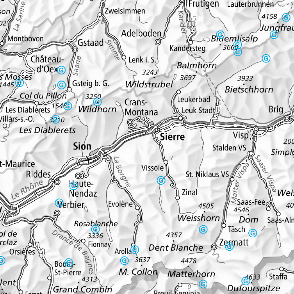
Gebirgslandeplätze sind Landestellen ausserhalb von Flugplätzen und ohne Infrastruktur, die über 1100 Meter über Meer liegen. Sie dienen einerseits zu Ausbildungs- und Übungszwecken, anderseits für Personentransporte zu touristischen Zwecken. Die massgebende Liste der durch das BAZL zugelassenen Gebirgslandeplätze mit spezifischen Zusatzangaben ist in der Luftfahrtpublikation der Schweiz im VFR Manual unter AGA 3-3-1 publiziert. Benützung der Gebirgslandeplätze mit Flächenflugzeugen: Nur bei entsprechender Eignung des Gebirgslandeplatzes. Benützung der Gebirgslandeplätze mit Helikopter: Der Ort der Aussenlandung darf, in einem vernünftigen Umkreis, der im Rahmen der Ortsumschreibung bis 400 m um die Koordinaten betragen kann, gewählt werden (Entscheid des Bundesrates vom 7. Mai 1980). Hinweis: Keine offizielle Luftfahrtdatenpublikation. Die publizierten Daten entsprechen möglicherweise nicht dem letzten operationellen Datenstand.
Les places d'atterrissage en montagne (PAM) sont des terrains d'atterrissage situés en dehors des aérodromes - donc sans infrastructure - et à plus de 1100 m d'altitude. Elles sont utilisées d'une part pour l'instruction et l'entraînement, d'autre part pour le transport de personnes à des fins touristiques. La liste déterminante des places d'atterrissage en montagne agréées par l’OFAC, accompagnée d'informations détaillées, est publiée dans le feuillet AGA 3-3-1 du VFR Manual. Utilisation des places d'atterrissage en montagne par des avions: uniquement si la place s'y prête. Utilisation des places d'atterrissage en montagne par des hélicoptères: le lieu d'atterrissage peut être choisi à une distance raisonnable, soit un rayon pouvant aller jusqu'à 400 m du point déterminé par les coordonnées dans les limites de la description topographique (décision du Conseil fédéral du 7 mai 1980). Remarque: il ne s’agit pas d’une publication officielle des données aéronautiques. Les données publiées peuvent différer des dernières données en date.
Le aree d'atterraggio in montagna si trovano al di fuori di aerodromi, sono prive di infrastrutture e situate a un'altitudine superiore a 1100 m s.l.m. Servono da un lato per motivi formativi e di esercizio e, dall'altro, per il trasporto di viaggiatori a scopo turistico. L'elenco di riferimento delle aree d'atterraggio in montagna autorizzate dall'UFAC, incluse le specifiche informazioni supplementari, figura nella pubblicazione aeronautica ufficiale svizzera VFR Manual sotto AGA 3-3-1. Utilizzazione delle aree d'atterraggio in montagna mediante aerei: unicamente se le stesse sono confacenti. Utilizzazione delle aree d'atterraggio in montagna mediante elicotteri: il luogo d'atterraggio può essere scelto entro un raggio ragionevole che può arrivare fino ai 400 m dal punto determinato con le coordinate secondo la descrizione topografica (decisione del Consiglio federale del 7 maggio 1980). Nota: questa non è una pubblicazione ufficiale di dati aeronautici. I dati pubblicati potrebbero non corrispondere all’ultima versione dei dati aeronautici operativi.
Mountain landing sites are landing fields that are located outside an aerodrome at over 1100 m altitude and that have no infrastructure. They are used for instruction and training purposes, and to transport tourists. The authoritative list of mountain landing sites approved by the FOCA with specific additional information is published in the Swiss aeronautical publication in the VFR Manual under AGA 3-3-1. Use of mountain landing sites by fixed-wing aircraft: only if the site is suitable. Use of mountain landing sites by helicopters: outlanding may take place within a reasonable distance, i.e. within a radius of up to 400 m from the point determined by the coordinates within the limits of the topographical description (Swiss Federal Council decision of 7 May 1980). Please note: This is not an official aeronautical data publication. The information provided does not necessarily reflect the latest operational data.
Plazzas d'atterrament da muntogna èn lieus d'atterrament ordaifer plazzas aviaticas, che n'han nagina infrastructura e che sa chattan sur 1100 meters sur mar. Ellas servan d'ina vart ad intents da scolaziun e da trenament, da l'autra vart a transports da persunas per intents turistics. La glista decisiva da las plazzas d'atterrament da muntogna ch'èn admessas dal UFAC e che han indicaziuns supplementaras specificas è publitgada en il VFR Manual sut AGA 3-3-1. Utilisaziun da las plazzas d'atterrament da muntogna cun aviuns: mo sche la plazza d'atterrament da muntogna è adattada per quai. Utilisaziun da las plazzas d'atterrament da muntogna cun helicopters: il lieu d'atterrament dastga vegnir tschernì entaifer ina distanza raschunaivla che po divergiar fin a 400 m dal punct determinà cun las coordinatas tenor la descripziun topografica (decisiun dal Cussegl federal dals 7 da matg 1980). Infurmaziun: Quai n’è betg ina publicaziun uffiziala da datas d’aviaziun. Las datas publitgadas qua na correspundan eventualmain betg a l’ultim stadi da datas operaziunal.
Simple
-
Autre titreAltri nomi o acronimiAlternate titleAlternate titleAlternativtitel
-
Gebirgslandeplätze
Places d'atterrissage en montagne
Aree d'atterraggio in montagna
Mountain landing sites
Plazzas d'atterrament da muntogna
-
Date (Création)Data (Creazione)Date (Creation)Date (Creation)Datum (Erstellung)
- 2016-06-23T00:00:00
-
Date (Publication)Data (Pubblicazione)Date (Publication)Date (Publication)Datum (Publikation)
- 2025-03-20T00:00:00
-
IdentifiantIdentificatoreIdentifierIdentifierKennung
- ch.bazl.gebirgslandeplaetze
Point de contact
Punto di contatto
Point of contact
Point of contact
Ansprechpartner
-
Type de représentation spatialeTipo di rappresentazione spazialeSpatial representation typeSpatial representation typeRäumliche Darstellungsart
-
vecteurVettorialeVectorVectorVektor
Résolution spatiale
Risoluzione spaziale
Spatial resolution
Spatial resolution
Räumliche Auflösung
Fraction représentative
Frazione rappresentativa
Equivalent scale
Equivalent scale
Vergleichsmassstab
-
DénominateurDenominatoreDenominatorDenominatorMassstabszahl
- 5000
Résolution spatiale
Risoluzione spaziale
Spatial resolution
Spatial resolution
Räumliche Auflösung
Fraction représentative
Frazione rappresentativa
Equivalent scale
Equivalent scale
Vergleichsmassstab
-
DénominateurDenominatoreDenominatorDenominatorMassstabszahl
- 1000000
-
Catégorie de thèmeCategoria ISOTopic categoryTopic categoryThematik
-
-
P TransportP TrasportiP TransportationP TransportationP Verkehrswesen
-
Étendue
Estensione
Extent
Extent
Ausdehnung
Étendue
Estensione
Extent
Extent
Ausdehnung
-
DescriptionDescrizioneDescriptionDescriptionBeschreibung
-
Switzerland
Schweiz
Suisse
Svizzera
Svizra
))

Étendue
Estensione
Extent
Extent
Ausdehnung
Étendue
Estensione
Extent
Extent
Ausdehnung
-
DescriptionDescrizioneDescriptionDescriptionBeschreibung
-
Liechtenstein
Liechtenstein
Liechtenstein
Liechtenstein
Liechtenstein
))

-
Fréquence de mise à jourFrequenza di aggiornamentoMaintenance and update frequencyMaintenance and update frequencyWartungsintervall
-
InconnueSconosciutoUnknownUnknownUnbekannt
- geocat.ch
-
-
navigation aérienne
navigazione aerea
air navigation
-
aérodrome
aerodromo
airfield
-
linked data
linked data
linked data
-
opendata.swiss
opendata.swiss
opendata.swiss
opendata.swiss
-
- GEMET
-
-
trafic aérien
traffico aereo
air traffic
-
massif montagneux
catena montuosa
mountain range
-
- geocat.ch
-
-
BGDI Bundesgeodaten-Infrastruktur
IFDG l’Infrastructure Fédérale de données géographiques
IFDG Infrastruttura federale dei dati geografici
FSDI Federal Spatial Data Infrastructure
-
Contraintes sur la ressource
Vincoli sulle risorse
Resource constraints
Resource constraints
Ressourcenbeschränkungen
-
Contraintes d'utilisationVincoli d'usoUse constraintsUse constraintsNutzungseinschränkungen
-
Autres restrictionsAltre restrizioniOther restrictionsOther restrictionsAndere Beschränkungen
-
Autres contraintesAltri vincoliOther constraintsOther constraintsAndere Einschränkungen
- Opendata BY: Freie Nutzung. Quellenangabe ist Pflicht.Opendata BYOpendata BY: Utilisation libre. Obligation d’indiquer la source.Opendata BY: Libero utilizzo. Indicazione della fonte obbligatoria.Opendata BY: Open use. Must provide the source.Opendata BY: Open use. Must provide the source.
-
LangueLinguaLanguageLanguageSprache
- Deutsch
-
Encodage de caractèresCodifica dei caratteriCharacter encodingCharacter encodingZeichenkodierung
-
Utf8UTF8UTF8UTF8Utf8
-
Format de distributionFormato (codifica)Distribution formatDistribution formatAbgabeformat
-
-
ESRI Shapefile (SHP)
-
OGC Geopackage (GPKG)
-
Options de transfert numérique
Opzioni di trasferimento digitale
Digital transfer options
Digital transfer options
Optionen für die digitale Übertragung
-
Ressource en ligneRisorsa onlineOnLine resourceOnLine resourceOnline
-
Vorschau map.geo.admin.ch
Vorschau map.geo.admin.chAperçu map.geo.admin.chPrevisione map.geo.admin.chPreview map.geo.admin.ch
Options de transfert numérique
Opzioni di trasferimento digitale
Digital transfer options
Digital transfer options
Optionen für die digitale Übertragung
Options de transfert numérique
Opzioni di trasferimento digitale
Digital transfer options
Digital transfer options
Optionen für die digitale Übertragung
-
Ressource en ligneRisorsa onlineOnLine resourceOnLine resourceOnline
-
Linked Data Dienst BGDI
Options de transfert numérique
Opzioni di trasferimento digitale
Digital transfer options
Digital transfer options
Optionen für die digitale Übertragung
Options de transfert numérique
Opzioni di trasferimento digitale
Digital transfer options
Digital transfer options
Optionen für die digitale Übertragung
-
Ressource en ligneRisorsa onlineOnLine resourceOnLine resourceOnline
-
Linked Data
Options de transfert numérique
Opzioni di trasferimento digitale
Digital transfer options
Digital transfer options
Optionen für die digitale Übertragung
Options de transfert numérique
Opzioni di trasferimento digitale
Digital transfer options
Digital transfer options
Optionen für die digitale Übertragung
-
Ressource en ligneRisorsa onlineOnLine resourceOnLine resourceOnline
-
RESTful API von geo.admin.ch
RESTful API von geo.admin.chRESTful API de geo.admin.chRESTful API da geo.admin.chRESTful API from geo.admin.chRESTful API dad geo.admin.ch
Options de transfert numérique
Opzioni di trasferimento digitale
Digital transfer options
Digital transfer options
Optionen für die digitale Übertragung
-
Ressource en ligneRisorsa onlineOnLine resourceOnLine resourceOnline
-
ch.bazl.gebirgslandeplaetze
WMTS-BGDI Dienst, Layer "Gebirgslandeplätze"Service WMTS-IFDG, couche , Layer "Places d'atterrissage en montagne"Servizio WMTS-IFDG, strato "Aree d'atterraggio in montagna"WMTS-FSDI service, layer "Mountain landing sites"WMTS-BGDI Dienst, Layer "Gebirgslandeplätze"
Options de transfert numérique
Opzioni di trasferimento digitale
Digital transfer options
Digital transfer options
Optionen für die digitale Übertragung
Options de transfert numérique
Opzioni di trasferimento digitale
Digital transfer options
Digital transfer options
Optionen für die digitale Übertragung
-
Type d’objet géométriqueTipo di oggetto geometricoGeometric object typeGeometric object typeTyp des geometrischen Objekts
-
PointPuntoPointPointpoint
-
Nom du système de référenceNome del sistema di riferimentoReference system identifierReference system identifierName des Referenzsystems
- EPSG:2056
Metadata
-
Identifiant des métadonnéesIdentificativo della schedaMetadata identifierMetadata identifierIdentifikator des Metadatensatzes
- d31ecd5b-e00c-430b-ab2e-d9148a199b9c
-
LangueLinguaLanguageLanguageSprache
- Deutsch
-
Encodage de caractèresCodifica dei caratteriCharacter encodingCharacter encodingZeichenkodierung
-
Utf8UTF8UTF8UTF8Utf8
-
LangueLinguaLanguageLanguageSprache
- Français
-
Encodage de caractèresCodifica dei caratteriCharacter encodingCharacter encodingZeichenkodierung
-
Utf8UTF8UTF8UTF8Utf8
-
LangueLinguaLanguageLanguageSprache
- Italiano
-
Encodage de caractèresCodifica dei caratteriCharacter encodingCharacter encodingZeichenkodierung
-
Utf8UTF8UTF8UTF8Utf8
-
LangueLinguaLanguageLanguageSprache
- English
-
Encodage de caractèresCodifica dei caratteriCharacter encodingCharacter encodingZeichenkodierung
-
Utf8UTF8UTF8UTF8Utf8
-
LangueLinguaLanguageLanguageSprache
- Rumantsch
-
Encodage de caractèresCodifica dei caratteriCharacter encodingCharacter encodingZeichenkodierung
-
Utf8UTF8UTF8UTF8Utf8
Point de contact
Punto di contatto
Point of contact
Point of contact
Ansprechpartner
Type de ressource
Tipo di risorsa
Type of resource
Type of resource
Anwendungsbereich der Metadaten
-
Domaine d'application de la ressourceAmbito di applicazione della risorsaResource scopeResource scopeDomäne der Ressourcenanwendung
-
Jeu de donnéesSet di datiDatasetDatasetDatenbestand
-
Lien vers la métadonnéeCollegamento ai metadatiMetadata linkageMetadata linkageLink zu den Metadaten
-
Informations de date (Création)Informazioni sulla data (Creazione)Date info (Creation)Date info (Creation)Datumsangaben (Erstellung)
- 2016-06-24T15:19:39Z
-
Informations de date (Révision)Informazioni sulla data (Revisione)Date info (Revision)Date info (Revision)Datumsangaben (Aktualisierung)
- 2026-06-15T08:54:04.700432Z
Norme des métadonnées
Standard dei metadati
Metadata standard
Metadata standard
Metadatenstandard
-
TitreTitoloTitleTitleTitel
-
eCH-0271