geocat.ch
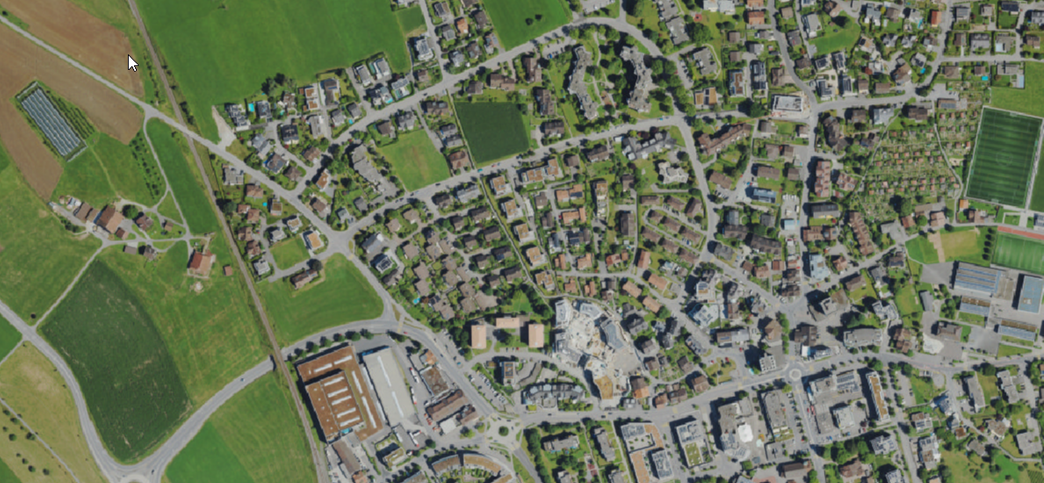
TrueDOP 2022 (ZG)
Das TrueOrthophoto 2022 des Kantons Zug ist ein flächendeckendes digitales Luftbild mit einer Bodenauflösung von 7.5 cm. Die Bildaufnahmen erfolgten zwischen dem 3. und 12. Juli 2022 und wurden zu einem geometrisch korrigierten True-Orthophoto verarbeitet. Im Gegensatz zu klassischen Orthofotos werden Gebäude, Brücken und andere erhöhte Objekte ohne Kippung und mit hoher Lagegenauigkeit dargestellt.
Der Datensatz dient als aktuelle und hochauflösende Bildgrundlage für raumbezogene Analysen, Kartendarstellungen und Planungsaufgaben. Sichtbar sind unter anderem Gebäude, Verkehrsflächen, Gewässer, Vegetation, landwirtschaftliche Flächen sowie weitere Landschafts- und Siedlungselemente.
Typische Anwendungsgebiete sind die Raumplanung, Vermessung, Bauprojekte, Infrastrukturplanung, Umweltanalysen, Dokumentation von Veränderungen sowie die visuelle Interpretation des Kantonsgebiets.
Simple
-
Date (Publication)Data (Pubblicazione)Date (Publication)Datum (Publikation)
- 2022-06-01
Propriétaire
Proprietario
Owner
Eigentümer
-
Heures de serviceOrario di servizioHours of serviceBetriebszeiten
-
08:00-11:45, 13:30-17:00
-
Type de représentation spatialeTipo di rappresentazione spazialeSpatial representation typeRäumliche Darstellungsart
-
grilleRasterGridRaster, Gitter
Résolution spatiale
Risoluzione spaziale
Spatial resolution
Räumliche Auflösung
-
Distance de résolutionDistanza di risoluzioneSpatial resolutionDistanz
- 0.075 m
-
Catégorie de thèmeCategoria ISOTopic categoryThematik
-
-
A Imagerie, cartes de base et occupation du solA Mappe di base con immagini della copertura terrestreA Imagery base maps earth coverA Oberflächenbeschreibung
-
Étendue
Estensione
Extent
Ausdehnung
Étendue
Estensione
Extent
Ausdehnung
-
DescriptionDescrizioneDescriptionBeschreibung
-
Canton of Zug (ZG)
Kanton Zug (ZG)
Canton de Zoug (ZG)
Cantone di Zugo (ZG)
))

-
Fréquence de mise à jourFrequenza di aggiornamentoMaintenance and update frequencyWartungsintervall
-
InconnueSconosciutoUnknownUnbekannt
Format de la ressource
Formato della risorsa
Resource format
Format der Ressource
-
TitreTitoloTitleTitel
-
GeoTIFF (GEOTIFF)
-
DateDataDateDatum
- geocat.ch
-
-
orthophoto
ortofoto
orthophoto
-
- GEMET
-
-
photographie aérienne
fotografia aerea (immagine)
aerial photograph
-
photographie aérienne
fotografia aerea (immagine)
aerial photograph
-
photographie aérienne
fotografia aerea (procedimento)
aerial photography
-
photographie aérienne
fotografia aerea (procedimento)
aerial photography
-
-
LangueLinguaLanguageSprache
- Deutsch
-
Encodage de caractèresCodifica dei caratteriCharacter encodingZeichenkodierung
-
Utf8UTF8UTF8Utf8
-
Catégorie de sous-thèmeCategoria di sottotemaSubtopic CategoryThematische Unterkategorien
-
A1 Cartes de base, modèles de paysageA1 Mappe di base, modelli paesaggisticiA1 Base Maps, Landscape ModelsA1 Basiskarten, Landschaftsmodelle
-
Catégorie de sous-thèmeCategoria di sottotemaSubtopic CategoryThematische Unterkategorien
-
A3 Images aériennes, satellitesA3 Immagini aeree e satellitariA3 Aerial and Satellite ImageryA3 Luft-, Satellitenbilder
Options de transfert numérique
Opzioni di trasferimento digitale
Digital transfer options
Optionen für die digitale Übertragung
-
Ressource en ligneRisorsa onlineOnLine resourceOnline
-
2022 TrueOrthofoto ZG
ZugMap, der öffentliche Geodaten-Viewer des GIS Kanton Zug
Identifiant
Identificativo
Identifier
Identifikator
-
CodeCodiceCodeCode
- EPSG:2056
-
DescriptionDescrizioneDescriptionBeschreibung
-
CH1903+ / LV95 (EPSG:2056)
Metadata
-
Identifiant des métadonnéesIdentificativo della schedaMetadata identifierIdentifikator des Metadatensatzes
- d2bb8424-3e09-46c0-8ff7-789dde8b74ef
-
LangueLinguaLanguageSprache
- Deutsch
-
Encodage de caractèresCodifica dei caratteriCharacter encodingZeichenkodierung
-
Utf8UTF8UTF8Utf8
-
LangueLinguaLanguageSprache
- Français
-
Encodage de caractèresCodifica dei caratteriCharacter encodingZeichenkodierung
-
Utf8UTF8UTF8Utf8
-
LangueLinguaLanguageSprache
- Italiano
-
Encodage de caractèresCodifica dei caratteriCharacter encodingZeichenkodierung
-
Utf8UTF8UTF8Utf8
-
LangueLinguaLanguageSprache
- English
-
Encodage de caractèresCodifica dei caratteriCharacter encodingZeichenkodierung
-
Utf8UTF8UTF8Utf8
Distributeur
Distributore
Distributor
Verteiler
-
Heures de serviceOrario di servizioHours of serviceBetriebszeiten
-
08:00-11:45, 13:30-17:00
Type de ressource
Tipo di risorsa
Type of resource
Anwendungsbereich der Metadaten
-
Domaine d'application de la ressourceAmbito di applicazione della risorsaResource scopeDomäne der Ressourcenanwendung
-
Jeu de donnéesSet di datiDatasetDatenbestand
-
Informations de date (Création)Informazioni sulla data (Creazione)Date info (Creation)Datumsangaben (Erstellung)
- 2023-06-06T12:18:35.089Z
-
Informations de date (Révision)Informazioni sulla data (Revisione)Date info (Revision)Datumsangaben (Aktualisierung)
- 2026-06-19T09:43:41.732906Z
Norme des métadonnées
Standard dei metadati
Metadata standard
Metadatenstandard
-
TitreTitoloTitleTitel
-
eCH-0271