geocat.ch
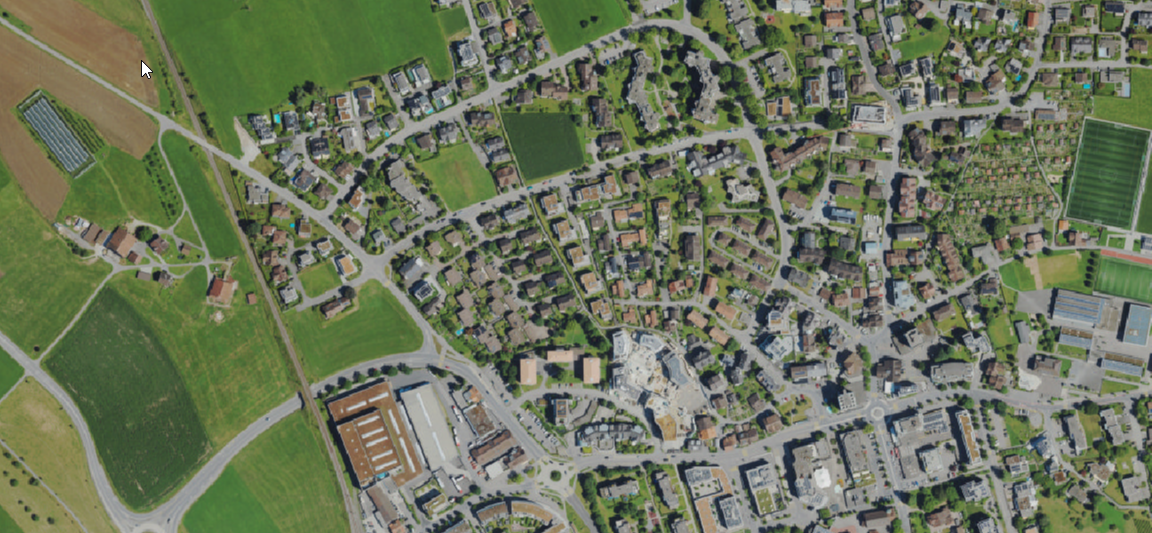
TrueDOP 2022 (ZG)
Das TrueOrthophoto 2022 des Kantons Zug ist ein flächendeckendes digitales Luftbild mit einer Bodenauflösung von 7.5 cm. Die Bildaufnahmen erfolgten zwischen dem 3. und 12. Juli 2022 und wurden zu einem geometrisch korrigierten True-Orthophoto verarbeitet. Im Gegensatz zu klassischen Orthofotos werden Gebäude, Brücken und andere erhöhte Objekte ohne Kippung und mit hoher Lagegenauigkeit dargestellt.
Der Datensatz dient als aktuelle und hochauflösende Bildgrundlage für raumbezogene Analysen, Kartendarstellungen und Planungsaufgaben. Sichtbar sind unter anderem Gebäude, Verkehrsflächen, Gewässer, Vegetation, landwirtschaftliche Flächen sowie weitere Landschafts- und Siedlungselemente.
Typische Anwendungsgebiete sind die Raumplanung, Vermessung, Bauprojekte, Infrastrukturplanung, Umweltanalysen, Dokumentation von Veränderungen sowie die visuelle Interpretation des Kantonsgebiets.
Simple
- Date (Publication)
- 2022-06-01
Owner
- Spatial representation type
- Grid
Spatial resolution
- Spatial resolution
- 0.075 m
- Topic category
-
- A Imagery base maps earth cover
Extent
Extent
- Description
-
Canton of Zug (ZG)
))

- Maintenance and update frequency
- Unknown
Resource format
- Title
-
GeoTIFF (GEOTIFF)
- Date
- geocat.ch
-
-
orthophoto
-
- GEMET
-
-
aerial photograph
-
aerial photograph
-
aerial photography
-
aerial photography
-
- Language
- Deutsch
- Character encoding
- UTF8
- Subtopic Category
- A1 Base Maps, Landscape Models
- Subtopic Category
- A3 Aerial and Satellite Imagery
Digital transfer options
- OnLine resource
-
2022 TrueOrthofoto ZG
ZugMap, der öffentliche Geodaten-Viewer des GIS Kanton Zug
Identifier
- Code
- EPSG:2056
- Description
-
CH1903+ / LV95 (EPSG:2056)
Metadata
- Metadata identifier
- d2bb8424-3e09-46c0-8ff7-789dde8b74ef
- Language
- Deutsch
- Character encoding
- UTF8
- Language
- Français
- Character encoding
- UTF8
- Language
- Italiano
- Character encoding
- UTF8
- Language
- English
- Character encoding
- UTF8
Distributor
Type of resource
- Resource scope
- Dataset
- Metadata linkage
-
https://www.geocat.ch/geonetwork/srv/api/records/d2bb8424-3e09-46c0-8ff7-789dde8b74ef
- Date info (Creation)
- 2023-06-06T12:18:35.089Z
- Date info (Revision)
- 2026-06-19T09:43:41.732906Z
Metadata standard
- Title
-
eCH-0271