 geocat.ch
Landeskarte 1:10'000 (farbig)
Carte nationale 1:10'000 (couleur)
Carta nazionale 1:10'000 (colori)
National Map 1:10'000 (color)
Charta naziunala 1:10'000 (colur)
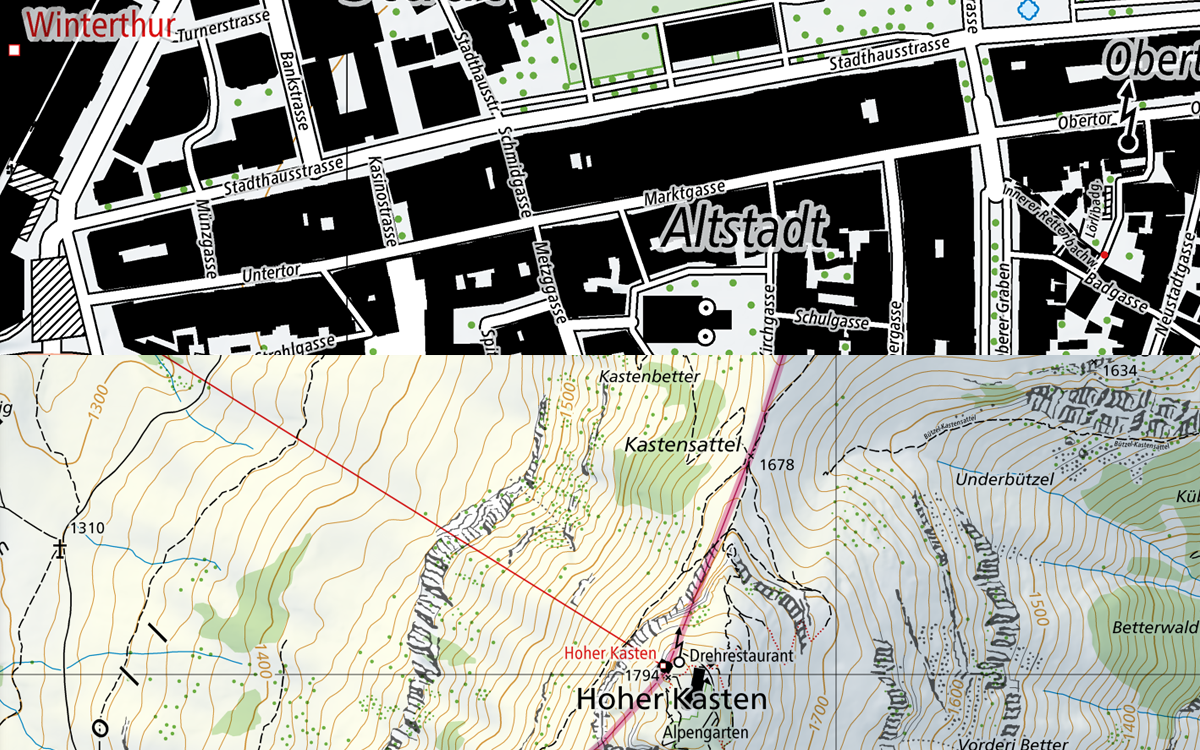
Die Landeskarte 1:10'000 ist die grossmassstäblichste topografische Karte von swisstopo. Sie zeichnet sich durch die sehr detaillierte Verkehrs-, Siedlungs-, Gelände- und Vegetationsdarstellung sowie einer dichten Beschriftung aus. Ergänzt werden die Inhalte mit der Felszeichnung und dem Relief. Der Kartenperimeter umfasst das Landesgebiet der Schweiz und des Fürstentums Liechtenstein. Die Nachführung erfolgt jährlich basierend auf der aktuellsten Version des Topografischen Landschaftsmodells TLM von swisstopo. Die Landeskarte 1:10'000 wird in digitaler Form farbig und in Graustufen erstellt. Beide Versionen dienen als Basiskarte in den ersten vier Zoomstufen im Geodatenviewer des Bundes map.geo.admin.ch. Die Landeskarte 1:10'000 steht ebenfalls als Swiss Map Raster 10 in Form von georeferenzierten TIF-Dateien und als Swiss Map Vector 10 zur Verfügung und kann für individuelle Perimeterausschnitte bezogen werden.
La carte nationale 1:10'000 est la carte topographique de plus grande échelle produite par swisstopo. Elle représente avec un grand niveau de détails les réseaux de transport, les localités, le terrain, la végétation, ainsi que des écritures encore plus denses. Le contenu est complété avec la représentation des rochers et du relief. Le périmètre de la carte comprend le territoire Suisse et la principauté du Liechtenstein. La mise à jour est faite annuellement sur la base actualisée du modèle topographique du paysage MTP de swisstopo. La carte nationale 1:10'000 sera produite au format digital en couleur ou en nuances de gris. Les deux versions servent de cartes de bases pour les 4 premiers niveaux de zoom du visualisateur de géodonnées de la confédération map.geo.admin.ch. La carte nationale 1:10'000 reste également disponible en tant que produit Swiss Map Raster 10 livré au format TIF géoréférencé et Swiss Map Vector 10 et peut être acheté sous forme d’un extrait de zone défini par l’utilisateur.
La Carta nazionale 1:10'000 è la carta topografica con la scala più elevata di swisstopo. È caratterizzata da una rappresentazione estremamente dettagliata delle vie di traffico, degli insediamenti, del terreno e della vegetazione nonché da iscrizioni estremamente fitte. I contenuti della carta sono integrati dalla rappresentazione dei rilievi e delle rocce. Il perimetro della carta comprende il territorio nazionale della Svizzera e del Principato del Liechtenstein. L'aggiornamento ha luogo sulla base della versione più aggiornata del modello topografico del paesaggio TLM di swisstopo. La Carta nazionale 1:10'000 viene realizzata in formato digitale a colori e in tonalità di grigio. Entrambe le versioni fungono da carta base nei primi quattro livelli di zoom nel visualizzatore di geodati della Confederazione map.geo.admin.ch. La Carta nazionale 1:10'000 è disponibile anche come Swiss Map Raster 10 sotto forma di file TIF georeferenziati e come Swiss Map Vector 10 e può essere reperita per estratti del perimetro personalizzati.
The 1:10,000 national map is swisstopo’s largest scale topographic map. It stands out for its detailed representation of traffic, settlements, terrain and vegetation as well as its thorough labelling. The contents are supplemented by rock hachures and relief. The perimeter of the map covers the national territory of both Switzerland and the Principality of Liechtenstein. Updates are made every year based on the latest version of swisstopo’s topographic landscape model (TLM). The 1:10,000 national map is produced in digital form in colour and greyscale. Both of these versions of the map form the basis for Switzerland’s geo data viewer (map.geo.admin.ch) in the first four zoom levels. The 1:10,000 map is also available as “Swiss Map Raster 10” in the form of geo-referenced TIF data and as "Swiss Map Vector 10" for individual sections of the perimeter.
La Charta naziunala 1:10'000 è la charta topografica da swisstopo cun la scala la pli gronda. Ella sa distingua tras ina preschentaziun fitg detagliada dal traffic, dals abitadis e da la vegetaziun sco er tras in grond dumber da legendas. Cumplettà vegn il cuntegn cun la preschentaziun da la structura da la grippa e cun il reliev. Il perimeter da la charta cumpiglia il territori da la Svizra e dal Principadi da Liechtenstein. L'actualisaziun vegn fatga annualmain sin basa da la versiun la pli actuala dal model topografic da la cuntrada (MTC) da swisstopo. La Charta naziunala 1:10'000 vegn fatga en furma digitala en colur ed en grisch. Tuttas duas versiuns servan sco charta da basa en ils emprims quatter stgalims da zoom dal program per visualisar geodatas da la Confederaziun map.geo.admin.ch. La Charta naziunala 1:10'000 stat medemamain a disposiziun sco Swiss Map Raster 10 en furma da datotecas georeferenziadas en il format TIF e sco Swiss Map Vector 10 e po vegnir retratga per extracts individualisads.
Simple
-
Autre titreAltri nomi o acronimiAlternate titleAlternate titleAlternativtitel
-
Landeskarte 1:10'000 (farbig) | LK10
Carte nationale 1:10'000 (couleur) | CN10
Carta nazionale 1:10'000 (colori) | CN10
National Map 1:10'000 (color) | NM10
Charta naziunala 1:10'000 (colur) | CN10
-
Date (Création)Data (Creazione)Date (Creation)Date (Creation)Datum (Erstellung)
- 2016-06-01
-
Date (Révision)Data (Revisione)Date (Revision)Date (Revision)Datum (Aktualisierung)
- 2025-05-01
-
IdentifiantIdentificatoreIdentifierIdentifierKennung
- ch.swisstopo.landeskarte-farbe-10
-
Forme de la présentationForma della presentazionePresentation formPresentation formPräsentationsform
-
Carte numériqueMappa digitaleDigital mapDigital mapDigitale Karte
-
ButScopoPurposePurposeZweck
-
Georeferenzdaten des Bundesrechts
Géodonnées de référence relevant du droit fédéral
Geodati di riferimento del diritto federale
-
ÉtatStatoStatusStatusBearbeitungsstatus
-
ContinuIn corsoOn goingOn goingKontinuierliche Aktualisierung
Point de contact
Punto di contatto
Point of contact
Point of contact
Ansprechpartner
Propriétaire
Proprietario
Owner
Owner
Eigentümer
-
Type de représentation spatialeTipo di rappresentazione spazialeSpatial representation typeSpatial representation typeRäumliche Darstellungsart
-
paperMappaperMappaperMappaperMappaperMap
-
Type de représentation spatialeTipo di rappresentazione spazialeSpatial representation typeSpatial representation typeRäumliche Darstellungsart
-
grilleRasterGridGridRaster, Gitter
-
Type de représentation spatialeTipo di rappresentazione spazialeSpatial representation typeSpatial representation typeRäumliche Darstellungsart
-
vecteurVettorialeVectorVectorVektor
Résolution spatiale
Risoluzione spaziale
Spatial resolution
Spatial resolution
Räumliche Auflösung
Fraction représentative
Frazione rappresentativa
Equivalent scale
Equivalent scale
Vergleichsmassstab
-
DénominateurDenominatoreDenominatorDenominatorMassstabszahl
- 10000
-
Catégorie de thèmeCategoria ISOTopic categoryTopic categoryThematik
-
-
A Imagerie, cartes de base et occupation du solA Mappe di base con immagini della copertura terrestreA Imagery base maps earth coverA Imagery base maps earth coverA Oberflächenbeschreibung
-
Étendue
Estensione
Extent
Extent
Ausdehnung
Étendue
Estensione
Extent
Extent
Ausdehnung
-
DescriptionDescrizioneDescriptionDescriptionBeschreibung
-
Switzerland
Schweiz
Suisse
Svizzera
Svizra
))

Étendue
Estensione
Extent
Extent
Ausdehnung
Étendue
Estensione
Extent
Extent
Ausdehnung
-
DescriptionDescrizioneDescriptionDescriptionBeschreibung
-
Liechtenstein
Liechtenstein
Liechtenstein
Liechtenstein
Liechtenstein
))

-
Fréquence de mise à jourFrequenza di aggiornamentoMaintenance and update frequencyMaintenance and update frequencyWartungsintervall
-
InconnueSconosciutoUnknownUnknownUnbekannt
Format de la ressource
Formato della risorsa
Resource format
Resource format
Format der Ressource
-
TitreTitoloTitleTitleTitel
-
Tagged Image File Format (TIFF)
-
DateDataDateDateDatum
- GEMET
-
-
cartographie
cartografia
cartography
-
bordure
frontiera
border
-
eaux (géographie)
acque (geografia)
water (geographic)
-
végétation
vegetazione
vegetation
-
relief
rilievo
relief (land)
-
- geocat.ch
-
-
réseau de transport
rete di trasporto
traffic network
-
carte nationale
carta nazionale
national map
-
représentation du terrain
rappresentazione del terreno
terrain representation
-
opendata.swiss
opendata.swiss
opendata.swiss
opendata.swiss
-
- GEMET - INSPIRE themes, version 1.0
-
-
Hydrographie
Idrografia
Hydrography
-
Bâtiments
Edifici
Buildings
-
Réseaux de transport
Reti di trasporto
Transport networks
-
Altitude
Elevazione
Elevation
-
Ortho-imagerie
Orto immagini
Orthoimagery
-
Occupation des terres
Copertura del suolo
Land cover
-
- geocat.ch
-
-
BGDI Bundesgeodaten-Infrastruktur
IFDG l’Infrastructure Fédérale de données géographiques
IFDG Infrastruttura federale dei dati geografici
FSDI Federal Spatial Data Infrastructure
-
- geocat.ch
-
-
Topografie
topographie
topografia
topography
-
- GEMET
-
-
Karte
cartogramme
mappa
map chart
-
Contraintes sur la ressource
Vincoli sulle risorse
Resource constraints
Resource constraints
Ressourcenbeschränkungen
-
Autres contraintesAltri vincoliOther constraintsOther constraintsAndere Einschränkungen
- Opendata BY: Freie Nutzung. Quellenangabe ist Pflicht.Opendata BY: Utilisation libre. Obligation d’indiquer la source.Opendata BY: Libero utilizzo. Indicazione della fonte obbligatoria.Opendata BY: Open use. Must provide the source.
Ressource associée
Risorsa associata
Associated resource
Associated resource
Verlinkte Ressource
-
TitreTitoloTitleTitleTitel
-
Landeskartenwerk 1:10'000 bis 1:1 Mio.
Cartes nationales du 1:10'000 au 1:1'000'000
Carte nazionali 1:10'000 - 1:1 mio.
National Maps 1:10'000 - 1:1 mio.
-
Type d'associationTipo di associazioneAssociation TypeAssociation TypeAssoziationstyp
-
Citation de travail plus largeCitazione di un'opera più ampiaReference to a master resource of which this one is a partReference to a master resource of which this one is a partÜbergeordneter Datenbestand
-
LangueLinguaLanguageLanguageSprache
- Deutsch
-
Encodage de caractèresCodifica dei caratteriCharacter encodingCharacter encodingZeichenkodierung
-
Utf8UTF8UTF8UTF8Utf8
-
LangueLinguaLanguageLanguageSprache
- Français
-
Encodage de caractèresCodifica dei caratteriCharacter encodingCharacter encodingZeichenkodierung
-
Utf8UTF8UTF8UTF8Utf8
-
LangueLinguaLanguageLanguageSprache
- Italiano
-
Encodage de caractèresCodifica dei caratteriCharacter encodingCharacter encodingZeichenkodierung
-
Utf8UTF8UTF8UTF8Utf8
-
LangueLinguaLanguageLanguageSprache
- Rumantsch
-
Encodage de caractèresCodifica dei caratteriCharacter encodingCharacter encodingZeichenkodierung
-
Utf8UTF8UTF8UTF8Utf8
-
Catégorie de sous-thèmeCategoria di sottotemaSubtopic CategorySubtopic CategoryThematische Unterkategorien
-
A1 Cartes de base, modèles de paysageA1 Mappe di base, modelli paesaggisticiA1 Base Maps, Landscape ModelsA1 Base Maps, Landscape ModelsA1 Basiskarten, Landschaftsmodelle
-
Géodonnées de baseGeodati di baseBasic GeodataBasic GeodataGeobasisdaten
- true
-
Identifiant Géodonnées de baseIdentificativo dei geodati di baseBasic Geodata IDBasic Geodata IDIdentifikator des Geobasisdatensatzes
-
42.15
-
Niveau des géodonnées de baseLivello legale dei geodati di baseBasic Geodata Legal LevelBasic Geodata Legal LevelGeobasisdatenebene
-
FédéralFederaleFederalFederalNational
-
Type de géodonnées de baseTipo di geodati di baseBasic Geodata TypeBasic Geodata TypeGeobasisdatentyp
-
Géodonnées de référenceGeodati di riferimentoReference GeodataReference GeodataGeoreferenzdaten
-
Format de distributionFormato (codifica)Distribution formatDistribution formatAbgabeformat
-
-
Cloud Optimized GeoTIFF (TIFF / TIF)
-
Point de contact
Punto di contatto
Point of contact
Point of contact
Ansprechpartner
-
TitreTitoloTitleTitleTitel
-
Tagged Image File Format (TIFF)
-
DateDataDateDateDatum
Options de transfert numérique
Opzioni di trasferimento digitale
Digital transfer options
Digital transfer options
Optionen für die digitale Übertragung
-
Ressource en ligneRisorsa onlineOnLine resourceOnLine resourceOnline
-
Vorschau map.geo.admin.ch
Vorschau map.geo.admin.chAperçu map.geo.admin.chPrevisione map.geo.admin.chPreview map.geo.admin.ch
Options de transfert numérique
Opzioni di trasferimento digitale
Digital transfer options
Digital transfer options
Optionen für die digitale Übertragung
-
Ressource en ligneRisorsa onlineOnLine resourceOnLine resourceOnline
-
ch.swisstopo.landeskarte-farbe-10
WMS-BGDI Dienst, Layer "Landeskarte 1:10`000 (farbig)"Service WMS-IFDG, couche "Carte nationale 1:10`000 (couleur)"Servizio WMS-IFDG, strato "Carta nazionale 1:10`000 (colori)"WMS-FSDI service, layer "National Map 1:10`000 (color)"WMS-BGDI Dienst, Layer "Landeskarte 1:10`000 (farbig)"
Options de transfert numérique
Opzioni di trasferimento digitale
Digital transfer options
Digital transfer options
Optionen für die digitale Übertragung
-
Ressource en ligneRisorsa onlineOnLine resourceOnLine resourceOnline
-
ch.swisstopo.landeskarte-farbe-10
WMTS-BGDI Dienst, Layer "Landeskarte 1:10'000 (farbig)"Service WMTS-IFDG, couche , Layer "Carte nationale 1:10'000 (couleur)"Servizio WMTS-IFDG, strato "Carta nazionale 1:10'000 (colori)"WMTS-FSDI service, layer "National Map 1:10'000 (color)"WMTS-BGDI Dienst, Layer "Landeskarte 1:10'000 (farbig)"
Options de transfert numérique
Opzioni di trasferimento digitale
Digital transfer options
Digital transfer options
Optionen für die digitale Übertragung
Options de transfert numérique
Opzioni di trasferimento digitale
Digital transfer options
Digital transfer options
Optionen für die digitale Übertragung
-
Généralités sur la provenanceInformazioni generali sulla provenienzaStatementStatementErklärung
-
Datenbasis: Topografisches Landschaftsmodell TLM; Digitales kartografisches Modell 1:25'000 (DKM25)
Données de base: Modèle topographique du paysage swissTLM3D; Modèle cartographique numérique 1:25'000 (DKM25)
Database: Modello topografico del paesaggi swissTLM3D; Modello cartografico digitale 1:25'000 (DKM25)
Database: Topographical landscape model swissTLM3D; Digital cartographic model 1: 25,000 (DKM25)
-
NiveauLivelloHierarchy levelHierarchy levelBezugsebene
-
Jeu de donnéesSet di datiDatasetDatasetDatenbestand
-
Nom du système de référenceNome del sistema di riferimentoReference system identifierReference system identifierName des Referenzsystems
- CH1903+
Metadata
-
Identifiant des métadonnéesIdentificativo della schedaMetadata identifierMetadata identifierIdentifikator des Metadatensatzes
- cb0f8401-c49a-4bdf-aff6-40a7015ba43a
-
LangueLinguaLanguageLanguageSprache
- Deutsch
-
Encodage de caractèresCodifica dei caratteriCharacter encodingCharacter encodingZeichenkodierung
-
Utf8UTF8UTF8UTF8Utf8
-
LangueLinguaLanguageLanguageSprache
- Français
-
Encodage de caractèresCodifica dei caratteriCharacter encodingCharacter encodingZeichenkodierung
-
Utf8UTF8UTF8UTF8Utf8
-
LangueLinguaLanguageLanguageSprache
- Italiano
-
Encodage de caractèresCodifica dei caratteriCharacter encodingCharacter encodingZeichenkodierung
-
Utf8UTF8UTF8UTF8Utf8
-
LangueLinguaLanguageLanguageSprache
- English
-
Encodage de caractèresCodifica dei caratteriCharacter encodingCharacter encodingZeichenkodierung
-
Utf8UTF8UTF8UTF8Utf8
-
LangueLinguaLanguageLanguageSprache
- Rumantsch
-
Encodage de caractèresCodifica dei caratteriCharacter encodingCharacter encodingZeichenkodierung
-
Utf8UTF8UTF8UTF8Utf8
Point de contact
Punto di contatto
Point of contact
Point of contact
Ansprechpartner
-
Heures de serviceOrario di servizioHours of serviceHours of serviceBetriebszeiten
-
08h30 - 11h00 / 14h00 - 16h00 GMT+1
Type de ressource
Tipo di risorsa
Type of resource
Type of resource
Anwendungsbereich der Metadaten
-
Domaine d'application de la ressourceAmbito di applicazione della risorsaResource scopeResource scopeDomäne der Ressourcenanwendung
-
Jeu de donnéesSet di datiDatasetDatasetDatenbestand
-
Lien vers la métadonnéeCollegamento ai metadatiMetadata linkageMetadata linkageLink zu den Metadaten
-
Informations de date (Création)Informazioni sulla data (Creazione)Date info (Creation)Date info (Creation)Datumsangaben (Erstellung)
- 2016-01-11T12:38:41Z
-
Informations de date (Révision)Informazioni sulla data (Revisione)Date info (Revision)Date info (Revision)Datumsangaben (Aktualisierung)
- 2026-04-13T09:14:52.817591Z
Norme des métadonnées
Standard dei metadati
Metadata standard
Metadata standard
Metadatenstandard
-
TitreTitoloTitleTitleTitel
-
eCH-0271
Overviews
Spatial extent

Provided by
