geocat.ch
Rock density
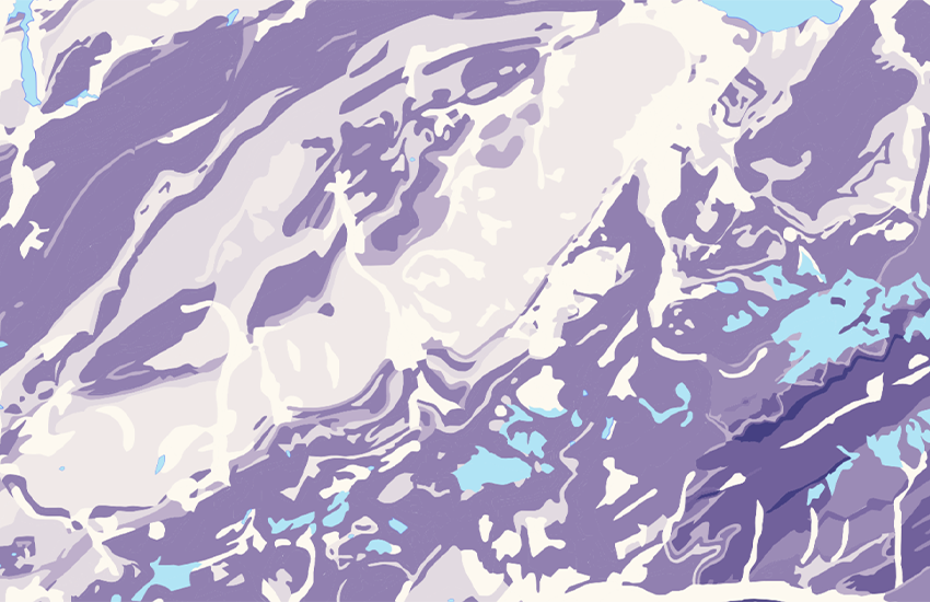
An important physical property of rock is its density, which depends mainly on mineralogy and porosity. Rocks made of minerals with a high content of magnesium, iron or other heavy metallic elements have a high density. In contrast, rocks that have a large proportion of alkalis (e.g. sodium, potassium) and silicon dioxide have a comparatively low density. Furthermore, rocks with a crystalline structure generally have a greater density than those with an amorphous (glassy) structure. Density is defined as mass per unit volume of a material [kg/m3]. While the so-called bulk density comprises the entire volume of a rock, the pure density (also called grain density) represents the volume without the empty spaces – i.e. without the porosity. Based on a database of density values, a bulk-density map of Switzerland was produced, which shows the mean value and other statistical data of all measured samples from each of the 21 lithological groups. Consequently, at no point does the density map show the expected absolute bulk density of a local rock type. Instead, it primarily shows the range in which the density of the local lithology varies. The data source, the data processing and the methodology used to produce the density map can be found in the publication by <a href=" https://sjg.springeropen.com/articles/10.1186/s00015-021-00389-3" target="_blank">Alba Zappone & Edi Kissling (2021, Swiss J. Geosciences)</a>.
Simple
- Alternate title
-
Rock density
- Date (Creation)
- 2020-10-01
- Date (Last Revision)
- 2020-10-01
- Identifier
- ch.swisstopo.geologie-gesteinsdichte
- Presentation form
- Digital map
- Purpose
-
Übersicht über die Rohdichte von Gesteinen in der Schweiz
- Status
- Under development
Owner
- Spatial representation type
- Vector
Spatial resolution
Equivalent scale
- Denominator
- 500000
- Topic category
-
- F Geoscientific information
Extent
Extent
- Description
-
Switzerland
))

- Maintenance and update frequency
- Irregular
- Duration of Conservation
- 275
- Appraisal of Archival Value
- A
- Reason for Archiving Value
- Evidence of business practice
- geocat.ch
-
-
geophysical map
-
FSDI Federal Spatial Data Infrastructure
-
well-consolidated rock
-
Conservation and archiving planning AAP - Confederation
-
- GEMET
-
-
geophysical environment
-
stone
-
density
-
physical property
-
geology
-
attribute
-
geophysics
-
Associated resource
- Title
-
Swiss Atlas of Physical Properties of Rocks (SAPHYR)
- Association Type
- Reference to a master resource of which this one is a part
- Language
- Deutsch
- Character encoding
- UTF8
- Subtopic Category
- F1 Geology
- Basic Geodata
- false
- Distribution format
-
-
ESRI Shapefile (SHP)
-
Digital transfer options
- OnLine resource
-
Produkte- und Bestellinformationen
Digital transfer options
- OnLine resource
-
Download (data.geo.admin.ch)
Digital transfer options
- OnLine resource
-
-
Digital transfer options
- OnLine resource
-
Thema Geologie (map.geologieportal.ch)
Digital transfer options
- OnLine resource
-
Schweiz. Geophysikalische Kommission SGPK
Digital transfer options
- OnLine resource
-
ch.swisstopo.geologie-gesteinsdichte
WMS-FSDI service, layer "Rock density"
Digital transfer options
- OnLine resource
-
ch.swisstopo.geologie-gesteinsdichte
WMTS-FSDI service, layer "Rock density"
Digital transfer options
- OnLine resource
-
RESTful API von geo.admin.ch
Digital transfer options
- OnLine resource
-
Vorschau map.geo.admin.ch
- Statement
-
Die Datenherkunft, Datenaufbereitung sowie die Methodik, welche für die Erstellung der Dichtekarte verwendet wurde, ist in der Publikation von Alba Zappone & Edi Kissling (2021, Swiss J. Geosciences) zu finden.
- Hierarchy level
- Dataset
- Reference system identifier
- Referenzsystem entsprechend der zugrundeliegenden topographischen Karte (LV95)
Metadata
- Metadata identifier
- c4a7ceb5-8bf5-457d-ab0a-57216dafce53
- Language
- Deutsch
- Character encoding
- UTF8
- Language
- Français
- Character encoding
- UTF8
- Language
- English
- Character encoding
- UTF8
- Language
- Italiano
- Character encoding
- UTF8
- Language
- Rumantsch
- Character encoding
- UTF8
Owner
Type of resource
- Resource scope
- Dataset
- Metadata linkage
-
https://www.geocat.ch/geonetwork/srv/api/records/c4a7ceb5-8bf5-457d-ab0a-57216dafce53
- Date info (Creation)
- 2020-09-25T08:38:55Z
- Date info (Revision)
- 2026-04-13T09:38:05.263474Z
Metadata standard
- Title
-
GM03 2+