geocat.ch
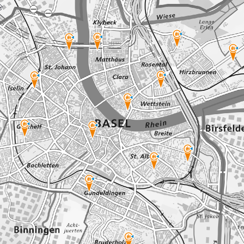
Notfalltreffpunkte
Die Notfalltreffpunkte Basel-Stadt sind Standorte, an denen Sie im Notfall jederzeit einen Notruf absetzen können. Sollte die übliche Informations- und Kommunikationstechnologie (IKT) – wie Festnetztelefon, Mobiltelefon oder Fernseher – infolge eines Ereignisses über längere Zeit ausfallen, erhalten Sie dort Informationen und Unterstützung durch die Behörden.
Simple
- Date (Creation)
- 2025-04-28
- Status
- Under development
Owner
- Spatial representation type
- Vector
- Topic category
-
- R Intelligence military
Extent
Extent
- Description
-
Canton of Basel-Stadt (BS)
))

- Maintenance and update frequency
- As needed
- GEMET
-
-
emergency lodging
-
police
-
Resource constraints
- Other constraints
-
Die Geodaten sind öffentlich zugänglich. (Zugangsberechtigungsstufe [A] = öffentlich)
- Other constraints
-
Es gelten die Nutzungsbedingungen für Geodaten des Kantons Basel-Stadt. ( http://www.geo.bs.ch/AGB)
Associated resource
- Association Type
- Reference to a master resource of which this one is a part
- Language
- Deutsch
- Character encoding
- UTF8
- Basic Geodata
- false
- Basic Geodata Legal Level
- Cantonal
- Distribution format
-
-
ESRI Shapefile (SHP)
-
ESRI File Geodatabase FileGDB (GDB)
-
OGC Geopackage (GPKG)
-
TEXT, comma separated (CSV)
-
GeoJSON (GEOJSON)
-
FlatGeobuf
-
GeoParquet
-
Digital transfer options
- OnLine resource
-
MapBS
Öffentliches Auskunftssystem des Kantons Basel-Stadt
Digital transfer options
- OnLine resource
-
Geodaten-Shop
Öffentlich zugänglicher Geodaten-Downloaddienst des Kantons Basel-Stadt
Digital transfer options
- OnLine resource
-
WMS BS
Die derzeit im WMS BS verfügbaren Datenebenen entsprechen, bis auf wenige Ausnahmen, den Geodaten, welche auch in MapBS dargestellt sind. Der WMS BS ist kostenlos nutzbar und bietet Zugriff auf öffentliche sowie beschränkt öffentliche Geodaten, wobei gegebenenfalls Benutzername und Passwort benötigt werden (Zugangsdaten von MapBS).
Digital transfer options
- OnLine resource
-
WFS BS
Die derzeit im WFS BS verfügbaren Datenebenen entsprechen, bis auf wenige Ausnahmen, den Geodaten, welche auch in MapBS dargestellt sind. Der WFS BS ist kostenlos nutzbar und bietet Zugriff auf öffentliche sowie beschränkt öffentliche Geodaten, wobei gegebenenfalls Benutzername und Passwort benötigt werden (Zugangsdaten von MapBS).
- Reference system identifier
- CH1903+ / LV95/EPSG: 2056
Metadata
- Metadata identifier
- bfef5b62-56c5-4fa7-ada9-0ea6ddf74646
- Language
- Deutsch
- Character encoding
- UTF8
- Language
- Français
- Character encoding
- UTF8
- Language
- Italiano
- Character encoding
- UTF8
- Language
- English
- Character encoding
- UTF8
Custodian
Type of resource
- Resource scope
- Dataset
- Metadata linkage
-
https://www.geocat.ch/geonetwork/srv/api/records/bfef5b62-56c5-4fa7-ada9-0ea6ddf74646
- Date info (Creation)
- 2025-04-28T08:53:19.757Z
- Date info (Revision)
- 2026-04-13T09:17:01.486058Z
Metadata standard
- Title
-
eCH-0271