geocat.ch
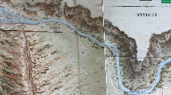
Plan Napoléon 1802
Plan ou plutôt carte de la plaine du Rhône, élaborée par les géographes français en 1802 sur demande de Napoléon
Simple
- Alternate title
-
Plan Napoléon 1802
- Date (Creation)
- 2005-11-20
- Identifier
- 205
- Purpose
-
Compléter la Carte de France
- Status
- Completed
Custodian
- Spatial representation type
- Grid
Spatial resolution
Equivalent scale
- Denominator
- 50000
- Topic category
-
- A Imagery base maps earth cover
Extent
Extent
- Description
-
Canton of Valais (VS)
))

- Maintenance and update frequency
- Not planned
Resource format
- Title
-
ESRI Enterprise Geodatabase
- Date
- GEMET themes
-
-
geography
-
- GEMET - INSPIRE themes, version 1.0
-
-
Geographical names
-
- GEMET
-
-
history
-
Resource constraints
- Use limitation
-
Contrat particulier à signer
Resource constraints
- Access constraints
- Other restrictions
- Other constraints
-
Géodonnées partiellement accessibles aux public (niveau B selon l'OGéo)
- Other constraints
-
Les conditions générales d'utilisation des géodonnées du Canton du Valais font foi ( https://www.vs.ch/fr/web/guest/information-legale).
- Language
- Français
- Character encoding
- UTF8
- Environment description
-
S:\Géodonnées VS\Z Projets\Rhône 3\Plan_Napoleon
- Subtopic Category
- A1 Base Maps, Landscape Models
- Distribution format
-
-
GeoTIFF (GEOTIFF)
-
Cloud Optimized GeoTIFF (TIFF / TIF)
-
Distributor
- Statement
-
Carte CHAN-F/14/10191-10192 (M. Lechevalier) de 1802
- Hierarchy level
- Dataset
- Description
-
Scannage
- Reference system identifier
- EPSG:2056/CH1903+_MN95
Metadata
- Metadata identifier
- bf682da4-6825-4ef3-827d-16d1b13a1e93
- Language
- Français
- Character encoding
- UTF8
- Language
- Deutsch
- Character encoding
- UTF8
- Language
- Italiano
- Character encoding
- UTF8
- Language
- English
- Character encoding
- UTF8
- Language
- Rumantsch
- Character encoding
- UTF8
Distributor
Type of resource
- Resource scope
- Dataset
- Metadata linkage
-
https://www.geocat.ch/geonetwork/srv/api/records/bf682da4-6825-4ef3-827d-16d1b13a1e93
- Date info (Creation)
- 2016-08-22T13:38:18Z
- Date info (Revision)
- 2026-04-13T09:31:30.762301Z
Metadata standard
- Title
-
eCH-0271