geocat.ch
swissTLM-Map (color)
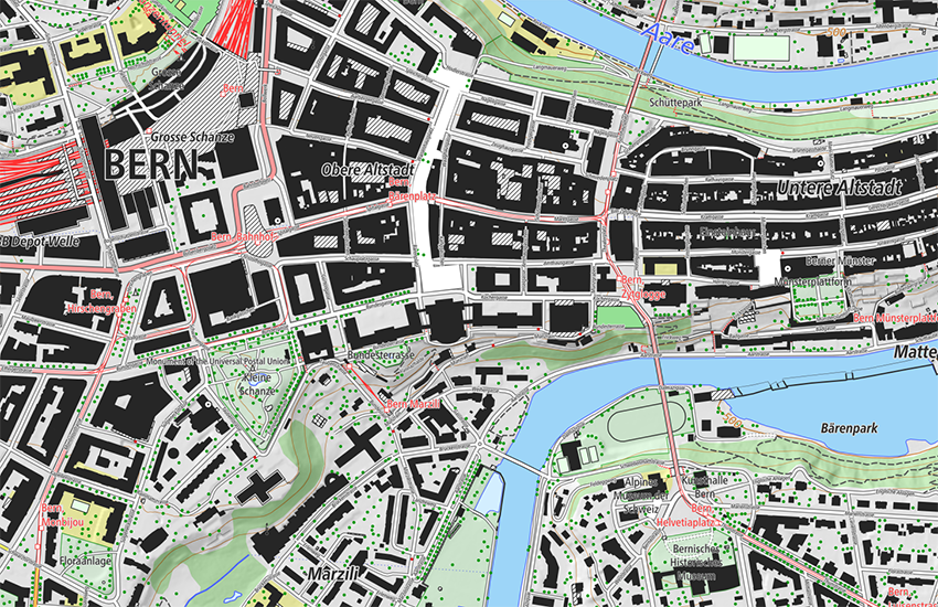
swissTLM-Map is an automatically generated map which offers a complement to the national maps in the scale range 1:5'000 to 1:10'000. swissTLM-Map is based on the data of the topographic landscape model swissTLM3D complemented by the contours and hillshade of the digital elevation model swissALTI3D.
Simple
- Alternate title
-
Map swissTLM (color)
- Date (Publication)
- 2025-04-09
- Date (Creation)
- 2012-01-01T00:00:00
- Date (Revision)
- 2025-03-05
- Edition
-
Version 2.3
- Edition date
- 2025-03-05T00:00:00
- Identifier
- ch.swisstopo.swisstlm3d-karte-farbe
- Status
- On going
Point of contact
Owner
- Spatial representation type
- Grid
Spatial resolution
Equivalent scale
- Denominator
- 5000
Spatial resolution
Equivalent scale
- Denominator
- 25000
- Topic category
-
- A Imagery base maps earth cover
Extent
Extent
- Description
-
Switzerland
))

Extent
Extent
- Description
-
Liechtenstein
))

- Maintenance and update frequency
- Annually
- Maintenance note
-
The existing data was migrated into the TLM as a basis. The data is then updated based on an update cycle of 6 years and improvements and additions are made to the geometries and attributes. Parallel to the six-year update process, an annual update is carried out through the integration of data from so-called reference partners for selected topics. Initially, this annual update is implemented mainly for the administrative boundaries, buildings and road links. The official cadastral survey plays an important role as a reference partner in this process. The nomenclature for updating names are also integrated from the official cadastral survey.
- Duration of Conservation
- 275
- Appraisal of Archival Value
- A
- Reason for Archiving Value
- Evidence of business practice
- Comment on Archival Value
-
Aus swissTLM3D abgeleitet
- geocat.ch
-
-
contour line
-
single object
-
Conservation and archiving planning AAP - Confederation
-
opendata.swiss
-
traffic network
-
base map
-
landscape model
-
GIS (Geographic Information System)
-
- GEMET
-
-
vector
-
geographic information system
-
public transport
-
- GEMET - INSPIRE themes, version 1.0
-
-
Hydrography
-
Land cover
-
Geographical names
-
- geocat.ch
-
-
FSDI Federal Spatial Data Infrastructure
-
- geocat.ch
-
-
topography
-
- GEMET
-
-
map chart
-
Resource constraints
- Use constraints
- Other restrictions
- Other constraints
-
NonCommercialAllowed-CommercialAllowed-ReferenceRequired
Associated resource
- Association Type
- Reference to a master resource of which this one is a part
- Metadata Reference
Associated resource
- Title
-
topographical landscape model (national survey)
- Association Type
- Reference to a master resource of which this one is a part
- Language
- Deutsch
- Character encoding
- UTF8
- Subtopic Category
- A1 Base Maps, Landscape Models
- Basic Geodata
- true
- Basic Geodata ID
-
38.1
- Basic Geodata Legal Level
- Federal
- Included with dataset
- 0
- Title
-
Objektkatalog swissTLM3D 2.2
- Date (Revision)
- 2024-03-06
- Distribution format
-
-
GeoTIFF (GEOTIFF)
-
Digital transfer options
- OnLine resource
-
Vorschau map.geo.admin.ch
Preview map.geo.admin.ch
Digital transfer options
- OnLine resource
-
ch.swisstopo.swisstlm3d-karte-farbe
WMS-FSDI service, layer "Map swissTLM (color)"
Digital transfer options
- OnLine resource
-
ch.swisstopo.swisstlm3d-karte-farbe
WMTS-FSDI service, layer "Map swissTLM (color)"
Digital transfer options
- OnLine resource
-
swissTLM3D
- Statement
-
Geometric accuracy: swissTLM3D (0.2 -1.5 m in all three dimensions for well-defined landscape features such as roads and buildings, 1 - 3 m in all three dimensions for landscape features which are not clearly defined such as forests)
- Hierarchy level
- Dataset
- Reference system identifier
- EPSG:21781
- Reference system identifier
- EPSG:2056
- Reference system identifier
- EPSG:5728
Metadata
- Metadata identifier
- b353f39c-6349-49e0-97d0-c522fc2fbf0f
- Language
- Deutsch
- Character encoding
- UTF8
- Language
- Français
- Character encoding
- UTF8
- Language
- Italiano
- Character encoding
- UTF8
- Language
- English
- Character encoding
- UTF8
- Language
- Rumantsch
- Character encoding
- UTF8
Point of contact
Type of resource
- Resource scope
- Dataset
- Metadata linkage
-
https://www.geocat.ch/geonetwork/srv/api/records/b353f39c-6349-49e0-97d0-c522fc2fbf0f
- Date info (Creation)
- 2013-11-18T12:06:13Z
- Date info (Revision)
- 2026-05-27T10:09:16.448228Z
Metadata standard
- Title
-
eCH-0271