 geocat.ch
Leitungskataster: Zuständigkeiten Ver- und Entsorgung
Kommunale Zuständigkeiten für die Leitungskataster Abwasser, Elektrizität, Telekommunikation und Wasser.Auskunft zu Leitungskataster/Werkinformationen für Planungs- und Bauvorhaben: Der Raumdatenpool und der Geodatenshop des Kanton Luzern bieten keine Daten zu Leitungskataster/Werkinformationen oder Webkarten (Expertviewer) an Dritte an. Die Daten dürfen auch nicht für Planungs- und Bauvorhaben oder ähnliche Projekte genutzt werden. Auskunft zu Leitungsmedien in Zuständigkeit der Gemeinden erhalten Sie von den GIS-Koordinatoren. Für Leitungsmedien wie Elektrizität oder Kommunikation erfolgt der Datenbezug direkt über die Werkbetreiber. Weitere Informationen siehe https://raumdatenpool.ch > Leitungskataster > Auskunft Leitungskataster für Planungs- und Bauvorhaben
Simple
- Alternate title
-
LKZSVEXX_COL
- Date (Creation)
- 2025-01-05
- Presentation form
- Digital map
- Purpose
-
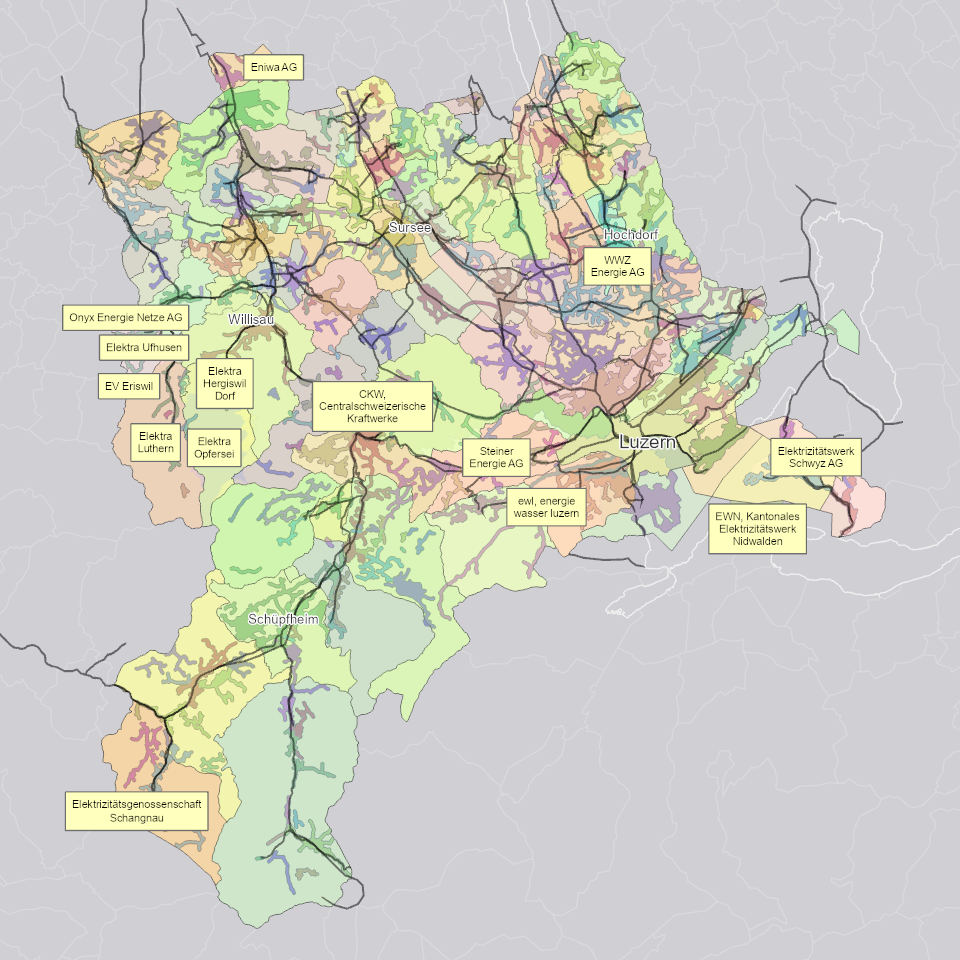
Übersicht zu den Versorgungsgebieten im Kantonsgebiet.
- Status
- On going
Publisher
Owner
- Spatial representation type
- undefined
- Topic category
-
- Q Utilities communication
Extent
Extent
- Description
-
Kanton Luzern
))
- Maintenance and update frequency
- As needed
- geocat.ch
-
-
opendata.swiss
-
Leitung
-
Leitungskataster
-
Ver- und Entsorgung
-
Resource constraints
- Access constraints
- none
- Use constraints
- Copyright
Resource constraints
- Use limitation
-
öffentlich zugängliche Geobasisdaten
Resource constraints
- Access constraints
- none
- Use constraints
- none
Resource constraints
- Use limitation
-
Freie Nutzung. Quellenangabe ist Pflicht
Associated resource
- Association Type
- Reference to a master resource of which this one is a part
- Metadata Reference
Associated resource
- Association Type
- Reference to a master resource of which this one is a part
- Metadata Reference
Associated resource
- Association Type
- Reference to a master resource of which this one is a part
- Metadata Reference
Associated resource
- Association Type
- Reference to a master resource of which this one is a part
- Metadata Reference
Associated resource
- Association Type
- Reference to a master resource of which this one is a part
- Metadata Reference
Associated resource
- Association Type
- Reference to a master resource of which this one is a part
- Metadata Reference
Associated resource
- Association Type
- Reference to a master resource of which this one is a part
- Metadata Reference
Associated resource
- Association Type
- Reference to a master resource of which this one is a part
- Metadata Reference
- Distribution format
-
-
ESRI Geodatabase (.gdb)
-
ESRI Shapefile (.shp)
-
OGC GeoPackage (.gpkg)
-
INTERLIS (.itf/.xtf)
-
Point of contact
Digital transfer options
- OnLine resource
-
Datenshop
Produktansicht Geodatenshop
- Statement
-
unbekannt
- Reference system identifier
- EPSG:2056
- Maintenance and update frequency
- As needed
Metadata
- Metadata identifier
- b3305b90-9d29-4bc4-ae2b-abb2727247be
- Language
- Deutsch
- Character encoding
- UTF-8
Point of contact
Type of resource
- Resource scope
- Dataset
- Metadata linkage
-
https://www.geocat.ch/geonetwork/srv/api/records/b3305b90-9d29-4bc4-ae2b-abb2727247be
- Date info (Creation)
- 2019-07-02
- Date info (Revision)
- 2026-06-20T03:22:32.697449Z
Metadata standard
- Title
-
ISO19115.3-2018.che
)))