geocat.ch
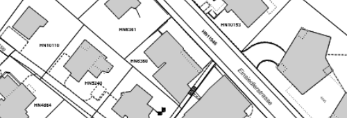
Amtliche Vermessung
Daten der amtliche Vermessung mit kommunalen Erweiterungen
Simple
- Date (Creation)
- 2015-01-01
- Status
- On going
Owner
- Spatial representation type
- Vector
- Topic category
-
- E Planning cadastre
Extent
Extent
- Description
-
Horgen
N
S
E
W
))

- Maintenance and update frequency
- Continual
Resource format
- Title
-
Oracle DB
- Date
- Edition
-
-
- geocat.ch
-
-
cadastral surveying
-
- GEMET
-
-
land register
-
land and property register
-
Resource constraints
- Other constraints
-
Öffentlich sichtbar, bestellbar, Dienst verfügbar
- Language
- Deutsch
- Character encoding
- UTF8
- Subtopic Category
- E2 Cadastre, Land Registry
- Distribution format
-
-
ESRI Shapefile (SHP)
-
AutoCAD DXF (DXF)
-
OGC Geopackage (GPKG)
-
GeoJSON (GEOJSON)
-
INTERLIS
-
Distributor
- Reference system identifier
- EPSG:2056
Metadata
- Metadata identifier
- a660c13c-3fcd-4351-b185-4d6f9b7dd2f1
- Language
- Deutsch
- Character encoding
- UTF8
- Language
- Français
- Character encoding
- UTF8
- Language
- Italiano
- Character encoding
- UTF8
- Language
- English
- Character encoding
- UTF8
Custodian
Type of resource
- Resource scope
- Dataset
- Metadata linkage
-
https://www.geocat.ch/geonetwork/srv/api/records/a660c13c-3fcd-4351-b185-4d6f9b7dd2f1
- Date info (Creation)
- 2021-10-19T06:52:51Z
- Date info (Revision)
- 2026-06-15T07:25:26.211406Z
Metadata standard
- Title
-
eCH-0271