geocat.ch
Tektonische Karte der Schweiz 1:500000
Carte tectonique de la Suisse au 1:500000
Carta tettonica della Svizzera 1:500000
Tectonic Map of Switzerland 1:500000
Charta tectonica da la Svizra 1:500000
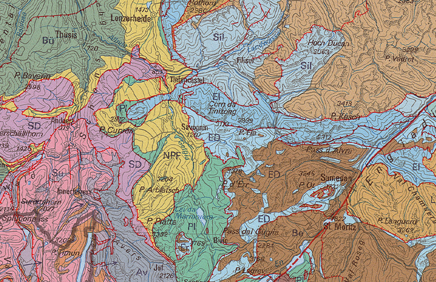
Die Tektonische Karte der Schweiz (TK500) zeigt die tektonischen Einheiten und Strukturelemente der Schweiz und der angrenzenden Gebiete. Die tektonischen Einheiten umfassen Gesteine mit einer ähnlichen geodynamischen Entwicklungsgeschichte und sind durch tektonische Störungen voneinander getrennt. Innerhalb einiger Einheiten wird zwischen dem kristallinen Grundgebirge und einer oder mehrerer sukzessiven Abfolgen der Sedimentbedeckung unterschieden. Die Einheiten werden zu strukturellen Domänen zusammengefasst, die durch bedeutende tektonische Störungen voneinander getrennt sind. Mittels Eingabe des Namens im Suchfeld können die Einheiten und Untereinheiten geortet werden, dasselbe gilt für gewisse Strukturlinien (nicht alle haben Namen). Die vorliegende Karte (4. Auflage, 2024) wird durch einen <a href=" https://www.geocat.ch/geonetwork/srv/api/records/a4cdef47-505e-41ab-b6a7-ad5b92d80e41/attachments/TK500-ERL.pdf?approved=true" target="_blank">Erläuterungstext</a>, in welchem jede dargestellte Einheit kurz beschrieben wird, ergänzt. Eine Tafelbeilage zeigt drei NW–SE bis N–S verlaufende <a href="https://www.geocat.ch/geonetwork/srv/api/records/a4cdef47-505e-41ab-b6a7-ad5b92d80e41/attachments/TK500_Plate-II_Profile.pdf?approved=true" target="_blank">tektonische Profile</a>, die das gesamte Kartengebiet durchziehen und die grossen Strukturen in der Tiefe wiedergeben. Auf einer weiteren Tafelbeilage ist die Entwicklung der räumlichen Beziehungen zwischen den verschiedenen auf der Karte ausgeschiedenen tektonischen Domänen anhand einer Abfolge von <a href="https://www.geocat.ch/geonetwork/srv/api/records/a4cdef47-505e-41ab-b6a7-ad5b92d80e41/attachments/TK500_Plate-III_Paleogeography.pdf?approved=true" target="_blank">paläogeographischen Skizzen</a> vom Mittleren Jura (170 Ma) bis heute dargestellt..
La Carte tectonique de la Suisse (TK500) illustre les unités tectoniques et des éléments structuraux de tout le territoire suisse et des régions avoisinantes. Les unités regroupent des roches ayant une histoire géodynamique commune et sont séparées les unes des autres par des discontinuités tectoniques. Au sein de certaines unités, une distinction a été faite entre socle cristallin et une ou plusieurs séries successives de couverture sédimentaire. Les unités sont regroupées en domaines structuraux séparés par des discontinuités tectoniques majeures. Les unités et sous-unités peuvent être localisées en écrivant leur nom dans le champ de recherche, de même pour certaines lignes structurales (toutes n’ont pas de nom). La carte actuelle (4e édition, 2024) est accompagnée d’une <a href=" https://www.geocat.ch/geonetwork/srv/api/records/a4cdef47-505e-41ab-b6a7-ad5b92d80e41/attachments/TK500-ERL.pdf?approved=true" target="_blank">notice explicative</a> qui donne une brève définition de chaque unité représentée. Une planche annexe présente trois <a href="https://www.geocat.ch/geonetwork/srv/api/records/a4cdef47-505e-41ab-b6a7-ad5b92d80e41/attachments/TK500_Plate-II_Profile.pdf?approved=true" target="_blank">coupes tectoniques</a> d’orientation NW–SE à N–S, traversant tout le secteur de la carte et montrant les grandes structures en profondeur. Une autre planche réunit une série de <a href="https://www.geocat.ch/geonetwork/srv/api/records/a4cdef47-505e-41ab-b6a7-ad5b92d80e41/attachments/TK500_Plate-III_Paleogeography.pdf?approved=true" target="_blank">schémas paléogéographiques</a> depuis le Jurassique moyen (170 Ma) jusqu’à aujourd’hui, qui montrent l’évolution des relations spatiales entre les différents domaines tectoniques couverts par la carte.
La Carta tettonica della Svizzera (TK500) illustra le unità tettoniche e gli elementi strutturali dell'intera Svizzera e delle regioni limitrofe. Le unità raggruppano rocce con una storia geodinamica comune e sono separate tra loro da discontinuità tettoniche. All'interno di alcune unità, è stata introdotta una demarcazione tra basamento cristallino e una o più serie successive di copertura sedimentaria. Le unità sono raggruppate in domini strutturali separati dalle discontinuità tettoniche principali. Le unità e le sottounità possono essere localizzate inserendo il loro nome nel campo di ricerca, così come alcune linee strutturali (non tutte hanno un nome). La carta attuale (4a edizione, 2024) è accompagnata da <a href=" https://www.geocat.ch/geonetwork/srv/api/records/a4cdef47-505e-41ab-b6a7-ad5b92d80e41/attachments/TK500-ERL.pdf?approved=true" target="_blank">note esplicative</a> che forniscono una breve definizione di ciascuna unità rappresentata. Una tavola allegata mostra tre <a href="https://www.geocat.ch/geonetwork/srv/api/records/a4cdef47-505e-41ab-b6a7-ad5b92d80e41/attachments/TK500_Plate-II_Profile.pdf?approved=true" target="_blank">sezioni tettoniche</a> da NW–SE a N–S, che attraversano l'intera carta e mostrano le principali strutture in profondità. Un'altra tavola contiene una serie di <a href="https://www.geocat.ch/geonetwork/srv/api/records/a4cdef47-505e-41ab-b6a7-ad5b92d80e41/attachments/TK500_Plate-III_Paleogeography.pdf?approved=true" target="_blank">schemi paleogeografici</a> dal Giurassico Medio (170 Ma) ai giorni nostri, che rappresentano l'evoluzione delle relazioni spaziali tra i diversi domini tettonici dalla carta.
The Tectonic Map of Switzerland (TK500) depicts the tectonic units and structural elements of the entire Swiss territory and neighboring regions. These units group together rocks with a common geodynamic history and are separated from one another by tectonic discontinuities. Within some units, a distinction has been made between crystalline basement and one or more successive series of sedimentary cover. Units are grouped into structural domains separated by major tectonic discontinuities. Units and subunits can be located by entering their name in the search field, like some structural lines (not all have names). The current map (4th edition, 2024) is accompanied by an <a href=" https://www.geocat.ch/geonetwork/srv/api/records/a4cdef47-505e-41ab-b6a7-ad5b92d80e41/attachments/TK500-ERL.pdf?approved=true" target="_blank">explanatory note</a> providing a brief definition of each unit. A first enclosure contains three NW–SE to N–S <a href="https://www.geocat.ch/geonetwork/srv/api/records/a4cdef47-505e-41ab-b6a7-ad5b92d80e41/attachments/TK500_Plate-II_Profile.pdf?approved=true" target="_blank">tectonic cross-sections</a> through the entire map area, which also show the major structures at depth. A second enclosure contains a series of <a href="https://www.geocat.ch/geonetwork/srv/api/records/a4cdef47-505e-41ab-b6a7-ad5b92d80e41/attachments/TK500_Plate-III_Paleogeography.pdf?approved=true" target="_blank">paleogeographic diagrams</a>, from the Middle Jurassic (170 Ma) to the present day, showing the evolution of spatial relationships between the different tectonic domains covered by the map.
Simple
-
Autre titreAltri nomi o acronimiAlternate titleAlternate titleAlternativtitel
-
Tektonik 500
Tectonique 500
Tettonica 500
Tectonics 500
Tectonica 500
-
Date (Publication)Data (Pubblicazione)Date (Publication)Date (Publication)Datum (Publikation)
- 2005-12-31
-
Date (Création)Data (Creazione)Date (Creation)Date (Creation)Datum (Erstellung)
- 1980-01-01T00:00:00
-
Date (Révision)Data (Revisione)Date (Revision)Date (Revision)Datum (Aktualisierung)
- 2024-05-01
-
IdentifiantIdentificatoreIdentifierIdentifierKennung
- ch.swisstopo.geologie-tektonische_karte
-
Forme de la présentationForma della presentazionePresentation formPresentation formPräsentationsform
-
Carte papierMappa cartaceaHardcopy mapHardcopy mapPapierkarte
-
Forme de la présentationForma della presentazionePresentation formPresentation formPräsentationsform
-
Carte numériqueMappa digitaleDigital mapDigital mapDigitale Karte
-
NomNomeNameNameName
-
GeoKarten 500
-
ButScopoPurposePurposeZweck
-
Übersicht über die Tektonik der Schweiz
Vue d’ensemble de la tectonique en Suisse
-
ÉtatStatoStatusStatusBearbeitungsstatus
-
TerminéCompletatoCompletedCompletedAbgeschlossen
Distributeur
Distributore
Distributor
Distributor
Verteiler
Point de contact
Punto di contatto
Point of contact
Point of contact
Ansprechpartner
Propriétaire
Proprietario
Owner
Owner
Eigentümer
-
Type de représentation spatialeTipo di rappresentazione spazialeSpatial representation typeSpatial representation typeRäumliche Darstellungsart
-
grilleRasterGridGridRaster, Gitter
-
Type de représentation spatialeTipo di rappresentazione spazialeSpatial representation typeSpatial representation typeRäumliche Darstellungsart
-
vecteurVettorialeVectorVectorVektor
-
Type de représentation spatialeTipo di rappresentazione spazialeSpatial representation typeSpatial representation typeRäumliche Darstellungsart
-
paperMappaperMappaperMappaperMappaperMap
Résolution spatiale
Risoluzione spaziale
Spatial resolution
Spatial resolution
Räumliche Auflösung
Fraction représentative
Frazione rappresentativa
Equivalent scale
Equivalent scale
Vergleichsmassstab
-
DénominateurDenominatoreDenominatorDenominatorMassstabszahl
- 500000
-
Catégorie de thèmeCategoria ISOTopic categoryTopic categoryThematik
-
-
F Informations géoscientifiquesF Informazioni geoscientificheF Geoscientific informationF Geoscientific informationF Erdwissenschaften
-
Étendue
Estensione
Extent
Extent
Ausdehnung
Étendue
Estensione
Extent
Extent
Ausdehnung
-
DescriptionDescrizioneDescriptionDescriptionBeschreibung
-
National Map 1:500'000
Landeskarte 1:500'000
Carte nationale 1:500'000
Carta nazionale 1:500'000
Landeskarte 1:500'000
-
Identifiant géographiqueIdentificatore geograficoGeographic identifierGeographic identifierGeografische Kennung
- NM500LK500CN500CN500LK500
))

-
Fréquence de mise à jourFrequenza di aggiornamentoMaintenance and update frequencyMaintenance and update frequencyWartungsintervall
-
Comme nécessaireSecondo necessitàAs neededAs neededBei Bedarf
-
Durée de conservationDurata di conservazioneDuration of ConservationDuration of ConservationAufbewahrungsdauer NV in Jahren
- 275
-
Évaluation de la valeur archivistiqueValutazione del valore archivisticoAppraisal of Archival ValueAppraisal of Archival ValueBewertung Archivwürdigkeit
-
AAAAA
-
Raison de la valeur d'archivageMotivo del valore archivisticoReason for Archiving ValueReason for Archiving ValueBegründung Archivwürdigkeit
-
Preuve de la pratique couranteProva della pratica commercialeEvidence of business practiceEvidence of business practiceNachweis der Geschäftspraxis
- geocat.ch
-
-
Planification de la conservation et de l'archivage AAP - Conféderation
Pianificazione della conservazione e dell’archiviazione AAP - Confederazione
Conservation and archiving planning AAP - Confederation
-
- geocat.ch
-
-
carte géologique
carta geologica
geologic map
-
- geocat.ch
-
-
opendata.swiss
opendata.swiss
opendata.swiss
opendata.swiss
-
- geocat.ch
-
-
e-geo.ch
e-geo.ch
e-geo.ch
-
- geocat.ch
-
-
géodonnées de base
geodati di base
official geodata
-
- GEMET
-
-
tectonique
tettonica
tectonics
-
- GEMET
-
-
sciences de la terre
scienze della terra
earth science
-
- GEMET
-
-
massif montagneux
catena montuosa
mountain range
-
- geocat.ch
-
-
faille
faglia
fault
-
- GEMET
-
-
faille
faglia
fault
-
- GEMET - INSPIRE themes, version 1.0
-
-
Géologie
Geologia
Geology
-
- geocat.ch
-
-
BGDI Bundesgeodaten-Infrastruktur
IFDG l’Infrastructure Fédérale de données géographiques
IFDG Infrastruttura federale dei dati geografici
FSDI Federal Spatial Data Infrastructure
-
Ressource associée
Risorsa associata
Associated resource
Associated resource
Verlinkte Ressource
-
TitreTitoloTitleTitleTitel
-
Geologisches Kartenwerk
Cartes géologiques
Carte geologiche
Geological maps
-
Type d'associationTipo di associazioneAssociation TypeAssociation TypeAssoziationstyp
-
Citation de travail plus largeCitazione di un'opera più ampiaReference to a master resource of which this one is a partReference to a master resource of which this one is a partÜbergeordneter Datenbestand
-
LangueLinguaLanguageLanguageSprache
- Deutsch
-
Encodage de caractèresCodifica dei caratteriCharacter encodingCharacter encodingZeichenkodierung
-
Utf8UTF8UTF8UTF8Utf8
-
LangueLinguaLanguageLanguageSprache
- Français
-
Encodage de caractèresCodifica dei caratteriCharacter encodingCharacter encodingZeichenkodierung
-
Utf8UTF8UTF8UTF8Utf8
-
Informations supplémentairesInformazioni supplementariSupplemental InformationSupplemental InformationZusätzliche Informationen
-
Ce produit fait partie de la série des GéoCartes 500. Il est disponible en version imprimée (plié ou plano), carte-pixel et jeux de données vectorielles.
Dieses Produkt ist Bestandteil der Serie der Geokarten 500 und ist als Druckversion (gefalzt oder plano), Pixelkarte oder Vektordatensatz erhältlich.
-
Catégorie de sous-thèmeCategoria di sottotemaSubtopic CategorySubtopic CategoryThematische Unterkategorien
-
F1 GéologieF1 GeologiaF1 GeologyF1 GeologyF1 Geologie
-
Géodonnées de baseGeodati di baseBasic GeodataBasic GeodataGeobasisdaten
- true
-
Identifiant Géodonnées de baseIdentificativo dei geodati di baseBasic Geodata IDBasic Geodata IDIdentifikator des Geobasisdatensatzes
-
46.5
-
Niveau des géodonnées de baseLivello legale dei geodati di baseBasic Geodata Legal LevelBasic Geodata Legal LevelGeobasisdatenebene
-
FédéralFederaleFederalFederalNational
-
Format de distributionFormato (codifica)Distribution formatDistribution formatAbgabeformat
-
-
analog
-
GeoTIFF (GEOTIFF)
-
ESRI Shapefile (SHP)
-
Options de transfert numérique
Opzioni di trasferimento digitale
Digital transfer options
Digital transfer options
Optionen für die digitale Übertragung
-
Ressource en ligneRisorsa onlineOnLine resourceOnLine resourceOnline
-
Vorschau map.geo.admin.ch
Vorschau map.geo.admin.chAperçu map.geo.admin.chPrevisione map.geo.admin.chPreview map.geo.admin.ch
Options de transfert numérique
Opzioni di trasferimento digitale
Digital transfer options
Digital transfer options
Optionen für die digitale Übertragung
-
Ressource en ligneRisorsa onlineOnLine resourceOnLine resourceOnline
-
ch.swisstopo.geologie-tektonische_karte
WMS-BGDI Dienst, Layer "Tektonik 500"Service WMS-IFDG, couche "Tectonique 500"Servizio WMS-IFDG, strato "Tettonica 500"WMS-FSDI service, layer "Tectonics 500"WMS-BGDI Dienst, Layer "Tektonik 500"
Options de transfert numérique
Opzioni di trasferimento digitale
Digital transfer options
Digital transfer options
Optionen für die digitale Übertragung
-
Ressource en ligneRisorsa onlineOnLine resourceOnLine resourceOnline
-
ch.swisstopo.geologie-tektonische_karte
WMTS-BGDI Dienst, Layer "Tektonik 500"Service WMTS-IFDG, couche , Layer "Tectonique 500"Servizio WMTS-IFDG, strato "Tettonica 500"WMTS-FSDI service, layer "Tectonics 500"WMTS-BGDI Dienst, Layer "Tektonik 500"
Options de transfert numérique
Opzioni di trasferimento digitale
Digital transfer options
Digital transfer options
Optionen für die digitale Übertragung
Options de transfert numérique
Opzioni di trasferimento digitale
Digital transfer options
Digital transfer options
Optionen für die digitale Übertragung
Options de transfert numérique
Opzioni di trasferimento digitale
Digital transfer options
Digital transfer options
Optionen für die digitale Übertragung
Options de transfert numérique
Opzioni di trasferimento digitale
Digital transfer options
Digital transfer options
Optionen für die digitale Übertragung
Options de transfert numérique
Opzioni di trasferimento digitale
Digital transfer options
Digital transfer options
Optionen für die digitale Übertragung
Options de transfert numérique
Opzioni di trasferimento digitale
Digital transfer options
Digital transfer options
Optionen für die digitale Übertragung
-
Ressource en ligneRisorsa onlineOnLine resourceOnLine resourceOnline
-
RESTful API von geo.admin.ch
RESTful API von geo.admin.chRESTful API de geo.admin.chRESTful API da geo.admin.chRESTful API from geo.admin.chRESTful API dad geo.admin.ch
-
Nom du système de référenceNome del sistema di riferimentoReference system identifierReference system identifierName des Referenzsystems
- CH1903
Metadata
-
Identifiant des métadonnéesIdentificativo della schedaMetadata identifierMetadata identifierIdentifikator des Metadatensatzes
- a4cdef47-505e-41ab-b6a7-ad5b92d80e41
-
LangueLinguaLanguageLanguageSprache
- Deutsch
-
Encodage de caractèresCodifica dei caratteriCharacter encodingCharacter encodingZeichenkodierung
-
Utf8UTF8UTF8UTF8Utf8
-
LangueLinguaLanguageLanguageSprache
- Français
-
Encodage de caractèresCodifica dei caratteriCharacter encodingCharacter encodingZeichenkodierung
-
Utf8UTF8UTF8UTF8Utf8
-
LangueLinguaLanguageLanguageSprache
- Italiano
-
Encodage de caractèresCodifica dei caratteriCharacter encodingCharacter encodingZeichenkodierung
-
Utf8UTF8UTF8UTF8Utf8
-
LangueLinguaLanguageLanguageSprache
- English
-
Encodage de caractèresCodifica dei caratteriCharacter encodingCharacter encodingZeichenkodierung
-
Utf8UTF8UTF8UTF8Utf8
-
LangueLinguaLanguageLanguageSprache
- Rumantsch
-
Encodage de caractèresCodifica dei caratteriCharacter encodingCharacter encodingZeichenkodierung
-
Utf8UTF8UTF8UTF8Utf8
Point de contact
Punto di contatto
Point of contact
Point of contact
Ansprechpartner
Type de ressource
Tipo di risorsa
Type of resource
Type of resource
Anwendungsbereich der Metadaten
-
Domaine d'application de la ressourceAmbito di applicazione della risorsaResource scopeResource scopeDomäne der Ressourcenanwendung
-
Jeu de donnéesSet di datiDatasetDatasetDatenbestand
-
Lien vers la métadonnéeCollegamento ai metadatiMetadata linkageMetadata linkageLink zu den Metadaten
-
Informations de date (Création)Informazioni sulla data (Creazione)Date info (Creation)Date info (Creation)Datumsangaben (Erstellung)
- 2021-02-01T07:34:25Z
-
Informations de date (Révision)Informazioni sulla data (Revisione)Date info (Revision)Date info (Revision)Datumsangaben (Aktualisierung)
- 2026-04-13T09:36:21.931548Z
Norme des métadonnées
Standard dei metadati
Metadata standard
Metadata standard
Metadatenstandard
-
TitreTitoloTitleTitleTitel
-
eCH-0271