geocat.ch
Tectonic Map of Switzerland 1:500000
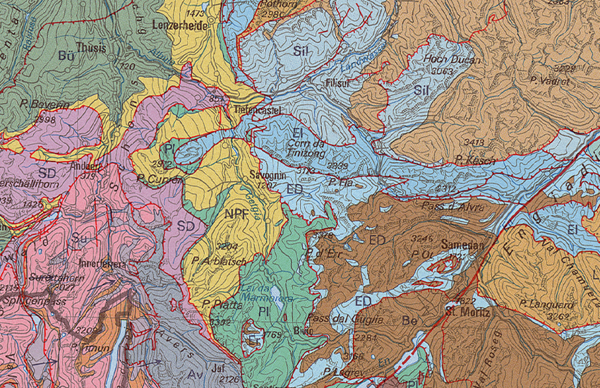
The Tectonic Map of Switzerland (TK500) depicts the tectonic units and structural elements of the entire Swiss territory and neighboring regions. These units group together rocks with a common geodynamic history and are separated from one another by tectonic discontinuities. Within some units, a distinction has been made between crystalline basement and one or more successive series of sedimentary cover. Units are grouped into structural domains separated by major tectonic discontinuities. Units and subunits can be located by entering their name in the search field, like some structural lines (not all have names). The current map (4th edition, 2024) is accompanied by an <a href=" https://www.geocat.ch/geonetwork/srv/api/records/a4cdef47-505e-41ab-b6a7-ad5b92d80e41/attachments/TK500-ERL.pdf?approved=true" target="_blank">explanatory note</a> providing a brief definition of each unit. A first enclosure contains three NW–SE to N–S <a href="https://www.geocat.ch/geonetwork/srv/api/records/a4cdef47-505e-41ab-b6a7-ad5b92d80e41/attachments/TK500_Plate-II_Profile.pdf?approved=true" target="_blank">tectonic cross-sections</a> through the entire map area, which also show the major structures at depth. A second enclosure contains a series of <a href="https://www.geocat.ch/geonetwork/srv/api/records/a4cdef47-505e-41ab-b6a7-ad5b92d80e41/attachments/TK500_Plate-III_Paleogeography.pdf?approved=true" target="_blank">paleogeographic diagrams</a>, from the Middle Jurassic (170 Ma) to the present day, showing the evolution of spatial relationships between the different tectonic domains covered by the map.
Simple
- Alternate title
-
Tectonics 500
- Date (Publication)
- 2005-12-31
- Date (Creation)
- 1980-01-01T00:00:00
- Date (Revision)
- 2024-05-01
- Identifier
- ch.swisstopo.geologie-tektonische_karte
- Presentation form
- Hardcopy map
- Presentation form
- Digital map
- Name
-
GeoKarten 500
- Purpose
-
Übersicht über die Tektonik der Schweiz
- Status
- Completed
Distributor
Point of contact
Owner
- Spatial representation type
- Grid
- Spatial representation type
- Vector
- Spatial representation type
- paperMap
Spatial resolution
Equivalent scale
- Denominator
- 500000
- Topic category
-
- F Geoscientific information
Extent
Extent
- Description
-
National Map 1:500'000
- Geographic identifier
- NM500
))

- Maintenance and update frequency
- As needed
- Duration of Conservation
- 275
- Appraisal of Archival Value
- A
- Reason for Archiving Value
- Evidence of business practice
- geocat.ch
-
-
Conservation and archiving planning AAP - Confederation
-
- geocat.ch
-
-
geologic map
-
- geocat.ch
-
-
opendata.swiss
-
- geocat.ch
-
-
e-geo.ch
-
- geocat.ch
-
-
official geodata
-
- GEMET
-
-
tectonics
-
- GEMET
-
-
earth science
-
- GEMET
-
-
mountain range
-
- geocat.ch
-
-
fault
-
- GEMET
-
-
fault
-
- geocat.ch
-
-
FSDI Federal Spatial Data Infrastructure
-
Associated resource
- Title
-
Geological maps
- Association Type
- Reference to a master resource of which this one is a part
- Language
- Deutsch
- Character encoding
- UTF8
- Language
- Français
- Character encoding
- UTF8
- Supplemental Information
-
Dieses Produkt ist Bestandteil der Serie der Geokarten 500 und ist als Druckversion (gefalzt oder plano), Pixelkarte oder Vektordatensatz erhältlich.
- Subtopic Category
- F1 Geology
- Basic Geodata
- true
- Basic Geodata ID
-
46.5
- Basic Geodata Legal Level
- Federal
- Distribution format
-
-
analog
-
GeoTIFF (GEOTIFF)
-
ESRI Shapefile (SHP)
-
Digital transfer options
- OnLine resource
-
Vorschau map.geo.admin.ch
Preview map.geo.admin.ch
Digital transfer options
- OnLine resource
-
ch.swisstopo.geologie-tektonische_karte
WMS-FSDI service, layer "Tectonics 500"
Digital transfer options
- OnLine resource
-
ch.swisstopo.geologie-tektonische_karte
WMTS-FSDI service, layer "Tectonics 500"
Digital transfer options
Digital transfer options
Digital transfer options
Digital transfer options
Digital transfer options
- OnLine resource
-
RESTful API von geo.admin.ch
RESTful API from geo.admin.ch
- Reference system identifier
- CH1903
Metadata
- Metadata identifier
- a4cdef47-505e-41ab-b6a7-ad5b92d80e41
- Language
- Deutsch
- Character encoding
- UTF8
- Language
- Français
- Character encoding
- UTF8
- Language
- Italiano
- Character encoding
- UTF8
- Language
- English
- Character encoding
- UTF8
- Language
- Rumantsch
- Character encoding
- UTF8
Point of contact
Type of resource
- Resource scope
- Dataset
- Metadata linkage
-
https://www.geocat.ch/geonetwork/srv/api/records/a4cdef47-505e-41ab-b6a7-ad5b92d80e41
- Date info (Creation)
- 2021-02-01T07:34:25Z
- Date info (Revision)
- 2026-04-13T09:36:21.931548Z
Metadata standard
- Title
-
GM03 2+