geocat.ch
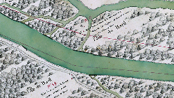
Carte Bas-Valais (1760)
Carte du Rhône en Bas-Valais, établie en 1760 sur demande des cantons de Bern et Valais
Simple
- Alternate title
-
Carte Bas-Valais (1760)
- Date (Creation)
- 1760-11-29T04:20:00
- Identifier
- 207
- Purpose
-
Documenter le tracé historique du Rhône
- Status
- Completed
Custodian
- Spatial representation type
- Grid
- Topic category
-
- I Inland waters
Extent
Extent
- Description
-
Canton of Valais (VS)
))

- Maintenance and update frequency
- Not planned
Resource format
- Title
-
Tagged Image File Format (TIFF)
- Date
- GEMET themes
-
-
water
-
- GEMET
-
-
hydrography
-
history
-
Resource constraints
- Use limitation
-
Aucunes
Resource constraints
- Access constraints
- Other restrictions
- Other constraints
-
Géodonnées accessibles au public (niveau A selon l'OGéo)
- Other constraints
-
Les conditions générales d'utilisation des géodonnées du Canton du Valais font foi ( https://www.vs.ch/fr/web/guest/information-legale).
- Language
- Français
- Character encoding
- UTF8
- Environment description
-
S:\Géodonnées VS\Z Projets\Rhône 3\Carte Bas-Valais (1760)
- Distribution format
-
-
GeoTIFF (GEOTIFF)
-
Cloud Optimized GeoTIFF (TIFF / TIF)
-
Distributor
- Statement
-
Plan graphique de 1760
- Hierarchy level
- Dataset
- Description
-
Scannage
- Reference system identifier
- EPSG:2056/CH1903+_MN95
Metadata
- Metadata identifier
- a3539c41-0b96-47f2-b38c-d8116afe033b
- Language
- Français
- Character encoding
- UTF8
- Language
- Deutsch
- Character encoding
- UTF8
- Language
- Italiano
- Character encoding
- UTF8
- Language
- English
- Character encoding
- UTF8
- Language
- Rumantsch
- Character encoding
- UTF8
Distributor
Type of resource
- Resource scope
- Dataset
- Metadata linkage
-
https://www.geocat.ch/geonetwork/srv/api/records/a3539c41-0b96-47f2-b38c-d8116afe033b
- Date info (Creation)
- 2016-08-23T12:24:46Z
- Date info (Revision)
- 2026-04-13T09:46:50.165792Z
Metadata standard
- Title
-
eCH-0271