geocat.ch
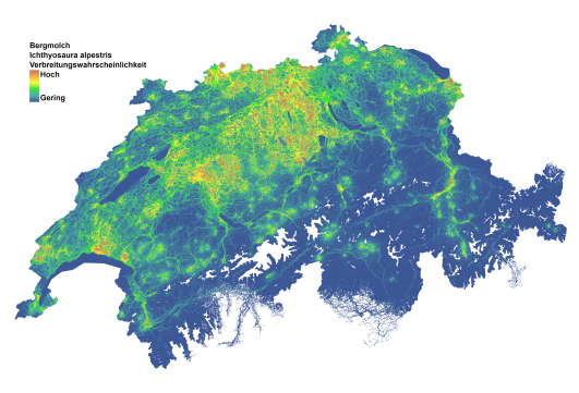
Amphibien Ausbreitungskarten - Ichthyosaura alpestris
Schweizweite Karte, die die Ausbreitungs-Wahrscheinlichkeit der Bergmolch (Ichthyosaura alpestris) darstellt. Jede Rasterzelle gibt die relative Wahrscheinlichkeit an, dass sich wandernde Individuen auf ihrem Weg zwischen bekannten Amphibienlaichgebiete durch diesen Hektar wandern. Die Karte zeigt die Ausbreitungs-Wahrscheinlichkeit, die entlang einer Skala von Blau über Gelb bis Rot zunimmt.
Diese Karten sollten als Heatmaps für die Ausbreitungsaktivität bestehender Populationen betrachtet werden. In der Praxis zeigen diese Karten auch Orte, an denen potenzielle neue Amphibienlaichgebiete die höchsten Chancen haben, besiedelt zu werden.
Gebiete mit vielen Populationen in unmittelbarer Nähe erscheinen dunkler rot, was die höhere Wahrscheinlichkeit einer Ausbreitung widerspiegelt, da sich mehrere Ausbreitungsrouten zwischen den Populationen überschneiden. Diese Eigenschaft der Karten verdient besondere Aufmerksamkeit. Hellere Schattierungen an den Rändern der Artenverbreitung bedeuten nicht unbedingt eine schwächere Verbindung zwischen den Populationen, sondern sind eher eine Folge der geringeren Dichte an Amphibienlaichgebieten an den Rändern der Verbreitung. Die Farbskala soll im Kontext der unmittelbaren Umgebung betrachtet werden.
Die Ausbreitungskarte wurde mit Circuitscape berechnet und basiert auf einer Landschaftswiderstandsmatrix, die aus dem am besten bewerteten Verbreitungsmodell für jede Art abgeleitet wurde.
Für Details, siehe die beigefügte Datenbeschreibung.
Literatur:
Swiss-wide map depicting the dispersal probability of the Smooth newt (Lissotriton vulgaris). Each grid cell indicates the relative probability that dispersing individuals will pass through that hectare on their way between known amphibian breeding sites. The map shows dispersal probability increasing along a scale from blue to yellow to red.
These maps should be thought of as heatmaps for dispersal activity of existing populations. In practical terms, these maps also show locations where potential new amphibian breeding sites have the highest chances of being colonized.
Areas with many populations in close proximity appear a darker red, reflecting the higher probability of dispersal as multiple dispersal routes between populations intersect. This feature of the maps deserves special attention. Lighter shades at the edges of the species' range do not necessarily indicate a weaker connection between populations, but rather a consequence of the lower density of breeding sites at the edges of the range. The color scale should be considered in the context of the immediate surroundings.
The dispersal map was calculated using Circuitscape and is based on a landscape resistance matrix derived from the best-ranked dispersal model for each species.
For details, see the attached data description.
Literature:
Churko G., Szerencsits E., Aldrich A., Schmidt B. R. (2024). Spatial analysis of the potential exposure of amphibians to plant protection products at the landscape scale. Basic and Applied Ecology, 76, 14-24. https://doi.org/10.1016/j.baae.2024.02.004
Semplice
- Data (Pubblicazione)
- 2024-02-23
- Identificatore
- ADN06
- Stato
- Completato
Autore
Ricercatore principale
Punto di contatto
- Tipo di rappresentazione spaziale
- Raster
Risoluzione spaziale
- Distanza di risoluzione
- 100 m
- Categoria ISO
-
- G Biota
- L Ambiente
- S Agricoltura
Estensione
Estensione
- Descrizione
-
Svizzera
))

- Frequenza di aggiornamento
- Non pianificato
Formato della risorsa
- Titolo
-
Tagged Image File Format (TIFF)
- Data
Formato della risorsa
- Titolo
-
Cloud Optimized GeoTIFF (TIFF / TIF)
- Data
- Edizione
-
-
- geocat.ch
-
-
confederazione
-
opendata.swiss
-
- GEMET themes
-
-
aree naturali, paesaggio, ecosistemi
-
agricoltura
-
- GEMET
-
-
agricoltura
-
anfibi
-
fauna
-
conservazione della natura
-
Vincoli sulle risorse
- Vincoli di accesso
- Copyright
- Vincoli d'uso
- Copyright
- Altri vincoli
- Opendata OPEN: Libero utilizzo.
- Altri vincoli
-
CC-Lizenz?
- Lingua
- Deutsch
- Codifica dei caratteri
- UTF8
- Categoria di sottotema
- L2 Protezione della natura e del paesaggio
- Geodati di base
- false
- Livello legale dei geodati di base
- Federale
- Tipo di geodati di base
- openData
- Formato (codifica)
-
-
Cloud Optimized GeoTIFF (TIFF / TIF)
-
Proprietario
Distributore
Opzioni di trasferimento digitale
- Risorsa online
-
Datenbeschreibung_AmphibienAckerland.pdf
Opzioni di trasferimento digitale
- Risorsa online
-
DescriptionDonnees_BatrachiensAgricole.pdf
- Tipo di oggetto geometrico
- Superficie
- Nome del sistema di riferimento
- LV95 EPSG:2056
- Frequenza di aggiornamento
- Secondo necessità
Metadati
- Identificativo della scheda
- 9ea54bf1-43b5-4cbd-ab46-0a9dd65567ce
- Lingua
- Deutsch
- Codifica dei caratteri
- UTF8
- Lingua
- English
- Codifica dei caratteri
- UTF8
- Lingua
- Français
- Codifica dei caratteri
- UTF8
- Lingua
- Italiano
- Codifica dei caratteri
- UTF8
- Lingua
- Rumantsch
- Codifica dei caratteri
- UTF8
Proprietario
Tipo di risorsa
- Ambito di applicazione della risorsa
- Set di dati
- Collegamento ai metadati
-
https://www.geocat.ch/geonetwork/srv/api/records/9ea54bf1-43b5-4cbd-ab46-0a9dd65567ce
- Informazioni sulla data (Creazione)
- 2024-03-18T14:01:46.618Z
- Informazioni sulla data (Revisione)
- 2026-04-13T09:17:30.181694Z
Standard dei metadati
- Titolo
-
eCH-0271