geocat.ch
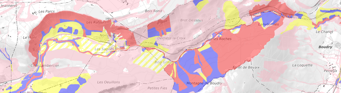
Carte de synthèse des dangers naturels avec cartes indicatives
La carte de synthèse est une combinaison (superposition) des cartes de dangers naturels et des cartes indicatives de danger, et cela pour chaque thématique (inondations, glissements de terrain, chutes de pierres, éboulements, affaissements, etc.). Le degré de danger (élevé = rouge, bleu = moyen, jaune = faible, jaune hachuré = résiduel) de la carte de synthèse correspond au degré de danger le moins favorable des cartes de chaque thématique.
Simple
- Date (Creation)
- 2025-10-01
Point of contact
Guichet cartographique en ligne du Canton de Neuchâtel
- Hours of service
-
08.00-12.00 et 13.30-17.00
Point of contact
- Spatial representation type
- Vector
Spatial resolution
Equivalent scale
- Denominator
- 5000
- Topic category
-
- E Planning cadastre
- I Inland waters
- O Structure
- F Geoscientific information
- M Society
Extent
Extent
- Description
-
Canton of Neuchâtel (NE)
))

- Maintenance and update frequency
- Unknown
- GEMET
-
-
hazard
-
lake
-
watercourse
-
flooding
-
water (geographic)
-
flood
-
- geocat.ch
-
-
rockfall
-
slide
-
hazard map
-
- Language
- Français
- Subtopic Category
- E1 Spatial Planning, Spatial Development
- Subtopic Category
- F1 Geology
- Subtopic Category
- F3 Natural Hazards
- Distribution format
-
-
MapInfo TAB file (TAB)
-
ESRI Shapefile (SHP)
-
Digital transfer options
- OnLine resource
-
Géoportail en ligne
Consultation possible sur le guichet en ligne
Digital transfer options
- OnLine resource
-
Commande en ligne
Commande en ligne par le geoshop
- Statement
-
Les études ont été pilotées par le canton (SAT – géologue cantonal, BOAEE – ingénieure responsable technique économie des eaux, SITN – responsable du SITN) et validées par la confédération.
- Hierarchy level
- Dataset
- Reference system identifier
- CH1903+/MN95, Système de coordonnées nationales (EPSG:2056)
Metadata
- Metadata identifier
- 99f8cb75-86db-4bf4-861a-2de8ab5f5303
- Language
- Français
- Language
- Deutsch
- Language
- Italiano
- Language
- English
Point of contact
Guichet cartographique en ligne du Canton de Neuchâtel
- Hours of service
-
08.00-12.00 et 13.30-17.00 sauf le vendredi après-midi
Point of contact
Guichet cartographique en ligne du Canton de Neuchâtel
- Hours of service
-
Tous les matins de 08:00 à 12:00
Type of resource
- Resource scope
- Dataset
- Name
-
Dangers naturels
- Metadata linkage
-
https://www.geocat.ch/geonetwork/srv/api/records/99f8cb75-86db-4bf4-861a-2de8ab5f5303
- Date info (Creation)
- 2025-10-16T09:00:04.42Z
- Date info (Revision)
- 2026-04-13T09:13:21.311177Z
Metadata standard
- Title
-
eCH-0271