geocat.ch
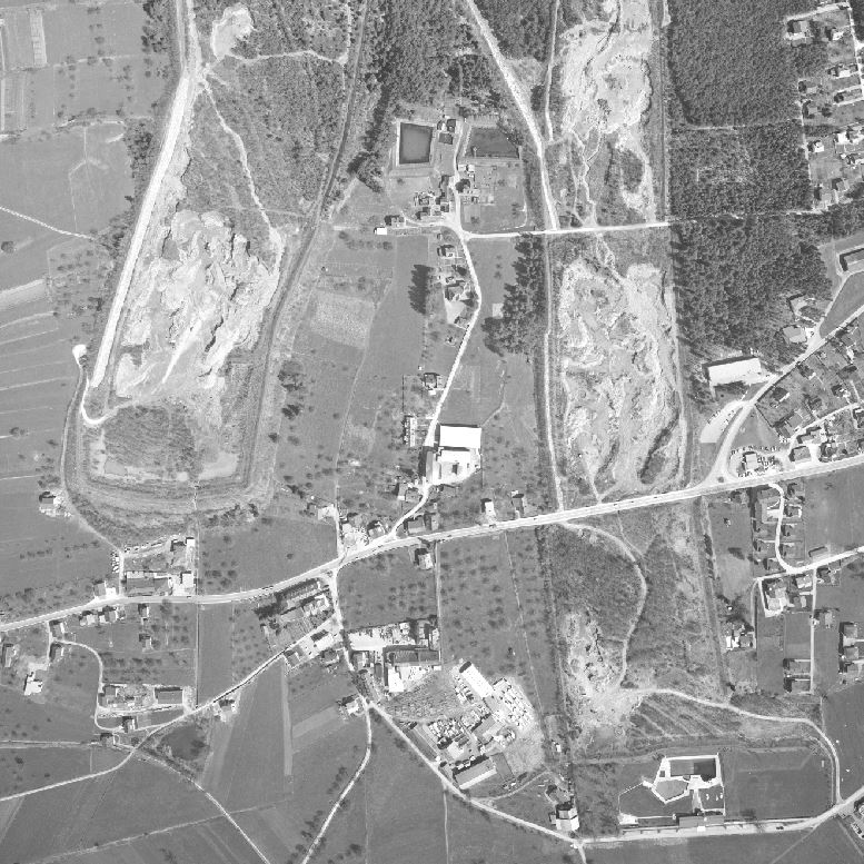
Aerial photographs Liechtenstein (1964 and 1970)
The data set consists of digitised aerial photographs of the so-called photogrammetric plans from 1964 and 1970, respectively, on which known boundary signs were marked and evaluated at a scale of 1:2000 (so-called aerial photographs, cadastral plans). The aerial photographs were digitised using an aerial scanner. The images are not georeferenced (no external orientation available), but are suitable for photogrammetric analysis or can be used to create an orthophoto if required.
Simple
- Alternate title
-
Digitised aerial photographs from 1964 and 1970
- Date (Creation)
- 1970-12-31
- Identifier
- https://metadata.geo.llv.li/99299914-18ab-4d65-938a-6385a2fb3399
- Purpose
-
Aerial photos from 1964 (Unterland) and 1970 (Oberland)
- Status
- Completed
Publisher
- Hours of service
-
8:00-11:30 und 13:30-17:00
- Spatial representation type
- Grid
Spatial resolution
- Spatial resolution
- 0.5 m
- Topic category
-
- A Imagery base maps earth cover
Extent
Extent
- Description
-
Liechtenstein
))

- Maintenance and update frequency
- Not planned
- geocat.ch
-
-
raster data
-
OpenData
-
- GEMET
-
-
aerial photograph
-
- GEMET - INSPIRE themes, version 1.0
-
-
Orthoimagery
-
- Räumlicher Anwendungsbereich
-
-
National
-
Resource constraints
- Use limitation
-
No Conditions Apply
- Access constraints
- Other restrictions
- Use constraints
- Other restrictions
- Other constraints
- No limitations to public access
Resource constraints
- Access constraints
- Other restrictions
- Use constraints
- Other restrictions
- Other constraints
- No conditions to access and use
- Other constraints
- Opendata BY: Open use. Must provide the source.
- Language
- Deutsch
- Character encoding
- UTF8
- Environment description
-
Luftbildbefliegung
- Subtopic Category
- A1 Base Maps, Landscape Models
- Subtopic Category
- A3 Aerial and Satellite Imagery
- Attribute description
- SW Farbwert
- Distribution format
-
-
Tagged Image File Format (TIFF)
-
Point of contact
- Hours of service
-
8:00-11:30 und 13:30-17:00
Digital transfer options
- OnLine resource
-
Geodatenportal
ATG website as a contact point
Digital transfer options
- OnLine resource
-
Download als Tiff File über das Geodatenportal
Download as tiff file via the geodata portal
- Hierarchy level
- Dataset
Report
Result
- Title
-
VERORDNUNG (EG) Nr. 1089/2010 DER KOMMISSION vom 23. November 2010 zur Durchführung der Richtlinie 2007/2/EG des Europäischen Parlaments und des Rates hinsichtlich der Interoperabilität von Geodatensätzen und -diensten
- Date (Creation)
- 2010-11-17
- Explanation
-
kein INSPIRE Datensatz
- Pass
- false
- Statement
-
Aerial photography
- Hierarchy level
- Dataset
- Number of dimensions
- 2
- Cell geometry
- Area
- Transformation parameter availability
- 0
- Reference system identifier
- https://www.opengis.net/def/crs/EPSG/0/2056
- Maintenance and update frequency
- As needed
Metadata
- Metadata identifier
- 99299914-18ab-4d65-938a-6385a2fb3399
- Language
- Deutsch
- Character encoding
- UTF8
- Language
- Français
- Character encoding
- UTF8
- Language
- Italiano
- Character encoding
- UTF8
- Language
- English
- Character encoding
- UTF8
Point of contact
- Hours of service
-
8:00-11:30 und 13:30-17:00
Type of resource
- Resource scope
- Dataset
- Metadata linkage
-
https://www.geocat.ch/geonetwork/srv/api/records/99299914-18ab-4d65-938a-6385a2fb3399
- Date info (Creation)
- 2010-11-17T08:18:19Z
- Date info (Revision)
- 2026-04-13T09:32:45.400229Z
Metadata standard
- Title
-
eCH-0271