geocat.ch
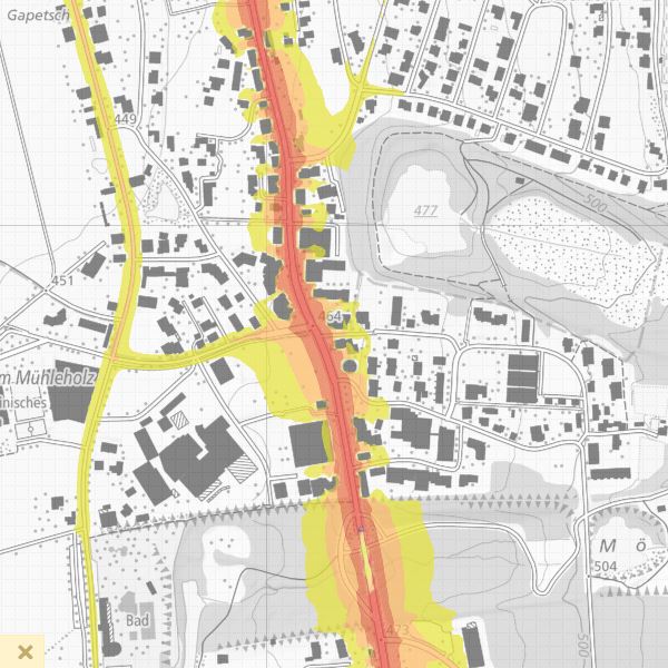
Strategic noise map - noise pollution LNight
In addition to the results of the noise registers based on the Liechtenstein Noise Abatement Ordinance, the strategic noise maps (Directive 2002/49/EC of the European Parliament and of the Council of 25 June 2002) provide a basis for comparing the noise situation in European countries. The strategic noise maps show the extent of noise pollution on highly frequented rural roads and thus form the basis for action planning in accordance with Directive 2002/49/EC.
Simple
- Alternate title
-
Strategic noise maps
- Date (Creation)
- 2013-11-13
- Identifier
- https://metadata.geo.llv.li/941ea0f9-dd89-4421-ab22-c349e2c07cf8
- Purpose
-
Noise protection
- Status
- Completed
Publisher
- Hours of service
-
8:00-11:30 und 13:30-17:00
Owner
- Hours of service
-
8:00-11:30 und 13:30-17:00
- Spatial representation type
- Vector
Spatial resolution
Equivalent scale
- Denominator
- 500
- Topic category
-
- K Climatology, meteorology, atmosphere
Extent
Extent
- Description
-
Liechtenstein
))

- Maintenance and update frequency
- As needed
- GEMET
-
-
environmental policy
-
noise, vibrations
-
noise pollutant
-
vector
-
- geocat.ch
-
-
INSPIRE
-
OpenData
-
- GEMET - INSPIRE themes, version 1.0
-
-
Environmental monitoring facilities
-
Human health and safety
-
- Räumlicher Anwendungsbereich
-
-
National
-
- GEMET themes
-
-
noise, vibrations
-
Resource constraints
- Use limitation
-
keine
- Access constraints
- Other restrictions
- Use constraints
- Other restrictions
- Other constraints
- No limitations to public access
Resource constraints
- Access constraints
- Other restrictions
- Use constraints
- Other restrictions
- Other constraints
- No conditions to access and use
- Other constraints
- Opendata BY: Open use. Must provide the source.
- Language
- Deutsch
- Character encoding
- UTF8
- Distribution format
-
-
INTERLIS 1 (ITF)
-
AutoCAD DXF (DXF)
-
ESRI Shapefile (SHP)
-
Point of contact
- Hours of service
-
8:00-11:30 und 13:30-17:00
Digital transfer options
- OnLine resource
-
Geodatenportal der Liechtensteinische Landesverwaltung
Geodata Portal of the National Administration
Digital transfer options
- OnLine resource
-
Homepage ATG, Datenausgabestelle
Data Distribution Office of the National Administration
- Hierarchy level
- Dataset
- Other
-
Alle Ebenen
Report
Result
- Title
-
COMMISSION REGULATION (EU) No 1089/2010 of 23 November 2010 implementing Directive 2007/2/EC of the European Parliament and of the Council as regards interoperability of spatial data sets and services
- Date (Publication)
- 2010-12-08
- Explanation
-
nicht geprüft
- Pass
- false
- Statement
-
gemäss der Richtlinie 2002/49/EG
- Hierarchy level
- Dataset
- Other
-
Alle Ebenen
- Topology level
- Full planar graph
- Geometric object type
- Surface
- Geometric object count
- 1
- Reference system identifier
- http://www.opengis.net/def/crs/EPSG/0/21782
- Reference system identifier
- http://www.opengis.net/def/crs/EPSG/0/4936
- Maintenance and update frequency
- As needed
Metadata
- Metadata identifier
- 941ea0f9-dd89-4421-ab22-c349e2c07cf8
- Language
- Deutsch
- Character encoding
- UTF8
- Language
- Français
- Character encoding
- UTF8
- Language
- Italiano
- Character encoding
- UTF8
- Language
- English
- Character encoding
- UTF8
Point of contact
- Hours of service
-
8:00-11:30 und 13:30-17:00
Type of resource
- Resource scope
- Dataset
- Metadata linkage
-
https://www.geocat.ch/geonetwork/srv/api/records/941ea0f9-dd89-4421-ab22-c349e2c07cf8
- Date info (Creation)
- 2021-04-21T11:45:13Z
- Date info (Revision)
- 2026-04-13T09:32:44.932233Z
Metadata standard
- Title
-
eCH-0271