 geocat.ch
Klimakarten
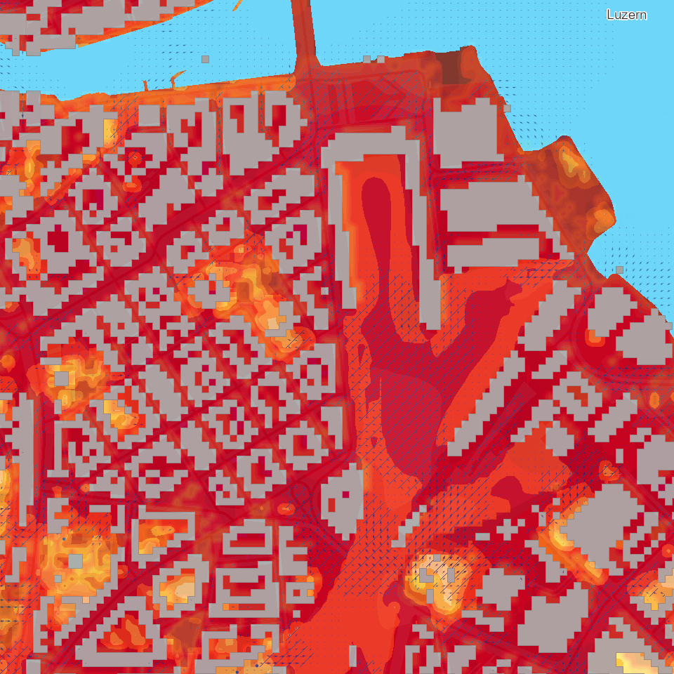
Die Klimakarten umfassen Klimaanalysekarten (Tag/Nacht) und Planungshinweiskarten (Tag/Nacht). Neben den Resultaten der FITNAH3D-Modellierung werden zur Orientierung die Eingangsdaten zur Landnutzung ebenfalls dargestellt. Die Daten umfassen Rasterdaten in einer Auflösung von 10x10m sowie Vektordaten.
Simple
- Alternate title
-
KAKXXXXX_COL
- Date (Creation)
- 2022-10-07
- Presentation form
- Digital map
- Purpose
-
Die Klimaanalysekarten zeigen die heutige lokalklimatische Situation im Kanton Luzern. In der Karte werden meteorologische Parameter wie Lufttemperatur, Winde und so weiter sowie das Kaltluftprozessgeschehen abgebildet. In den Planungshinweiskarten wird die Bewertung der klimatischen Situation aus Sicht der Einwohnerinnen und Einwohner dargestellt.Als Hintergrundinformation werden die Eingangsdaten zur Landnutzung eingebunden, welche neben der Geländehöhe, der Strukturhöhe (Gebäude, Vegetation) und den Wassertemperaturen als spezifische Eingangsdaten für das numerische Modell FITNAH3D aufbereitet wurden.Hinweis für den Datenbezug:Für einen kompletten Bezug der Kollektion müssen sowohl Rasterdaten (tif) wie auch Vektordaten (fgdb, shp, gpk) bezogen werden.
- Status
- Completed
Publisher
Owner
- Spatial representation type
- undefined
- Topic category
-
- K Climatology, meteorology, atmosphere
Extent
Extent
- Description
-
Kanton Luzern
))
- Maintenance and update frequency
- Not planned
- geocat.ch
-
-
opendata.swiss
-
Klima
-
Meteorologie
-
Raumplanung
-
Umweltbeobachtung
-
Siedlung
-
Resource constraints
- Access constraints
- none
- Use constraints
- Copyright
Resource constraints
- Use limitation
-
öffentlich zugängliche Geobasisdaten
Resource constraints
- Access constraints
- none
- Use constraints
- none
Resource constraints
- Use limitation
-
Freie Nutzung. Quellenangabe ist Pflicht
Associated resource
- Association Type
- Reference to a master resource of which this one is a part
- Metadata Reference
Associated resource
- Association Type
- Reference to a master resource of which this one is a part
- Metadata Reference
Associated resource
- Association Type
- Reference to a master resource of which this one is a part
- Metadata Reference
Associated resource
- Association Type
- Reference to a master resource of which this one is a part
- Metadata Reference
Associated resource
- Association Type
- Reference to a master resource of which this one is a part
- Metadata Reference
Associated resource
- Association Type
- Reference to a master resource of which this one is a part
- Metadata Reference
Associated resource
- Association Type
- Reference to a master resource of which this one is a part
- Metadata Reference
Associated resource
- Association Type
- Reference to a master resource of which this one is a part
- Metadata Reference
Associated resource
- Association Type
- Reference to a master resource of which this one is a part
- Metadata Reference
Associated resource
- Association Type
- Reference to a master resource of which this one is a part
- Metadata Reference
Associated resource
- Association Type
- Reference to a master resource of which this one is a part
- Metadata Reference
Associated resource
- Association Type
- Reference to a master resource of which this one is a part
- Metadata Reference
Associated resource
- Association Type
- Reference to a master resource of which this one is a part
- Metadata Reference
Associated resource
- Association Type
- Reference to a master resource of which this one is a part
- Metadata Reference
Associated resource
- Association Type
- Reference to a master resource of which this one is a part
- Metadata Reference
- Distribution format
-
-
Tagged Image File Format (.tif)
-
ESRI Geodatabase (.gdb)
-
ESRI Shapefile (.shp)
-
OGC GeoPackage (.gpkg)
-
Point of contact
Digital transfer options
- OnLine resource
-
Datenshop
Produktansicht Geodatenshop
- Statement
-
unbekannt
- Reference system identifier
- EPSG:2056
- Maintenance and update frequency
- Not planned
Metadata
- Metadata identifier
- 938d693a-ce77-470d-9d0a-7d676d362e5a
- Language
- Deutsch
- Character encoding
- UTF-8
Point of contact
Type of resource
- Resource scope
- Dataset
- Metadata linkage
-
https://www.geocat.ch/geonetwork/srv/api/records/938d693a-ce77-470d-9d0a-7d676d362e5a
- Date info (Creation)
- 2022-10-21
- Date info (Revision)
- 2026-06-19T03:30:02.887208Z
Metadata standard
- Title
-
ISO19115.3-2018.che
)))