geocat.ch
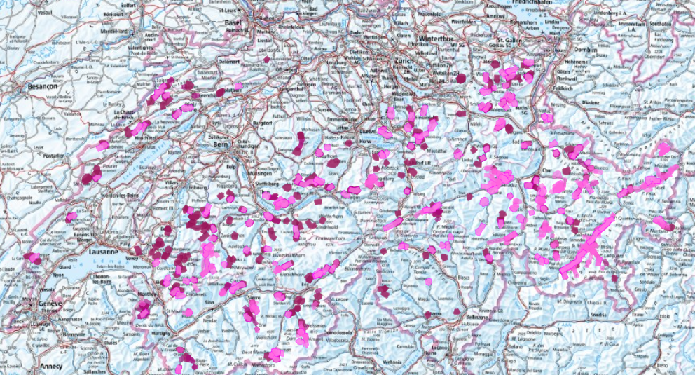
Snowshoe trails
The ‘Snowshoe trails’ dataset includes the best selection from SwitzerlandMobility (thick lines) and the other signposted trails from the cantons. This selection is coordinated with the Swiss Hiking Trail Association, the cantons and the Principality of Liechtenstein. This is currently (as of 12 November 2025) an initial data set containing the following information: SwitzerlandMobility trails throughout Switzerland, other signposted trails in the cantons of Jura, Schwyz, Graubünden and the Principality of Liechtenstein.
No liability is accepted for the accuracy, completeness or up-to-dateness of the route and trail data, and any liability for the use of this data is excluded. The signage and the weather and trail or route conditions on site are decisive.
Simple
- Alternate title
-
Snowshoe trails
- Date (Publication)
- 2025-11-12
- Date (Revision)
- 2026-01-19
- Identifier
- ch.astra.schneeschuhwanderwege
Point of contact
- Spatial representation type
- Vector
Spatial resolution
Equivalent scale
- Denominator
- 10000
- Topic category
-
- P Transportation
Extent
Extent
- Description
-
Switzerland (extent of the railway network with areas close to the border)
- Geographic identifier
- CH
))

- Maintenance and update frequency
- Annually
- Duration of Conservation
- 100
- Appraisal of Archival Value
- A
- Reason for Archiving Value
- Developments progression
- geocat.ch
-
-
snowshoe
-
human-powered mobility
-
official geodata
-
FSDI Federal Spatial Data Infrastructure
-
snowsport
-
confederation
-
Conservation and archiving planning AAP - Confederation
-
opendata.swiss
-
opendata.swiss
-
- GEMET
-
-
sport
-
snow
-
hiking trail
-
Resource constraints
- Other constraints
- Opendata BY: Open use. Must provide the source.
Resource constraints
- Classification
- Unclassified
Associated resource
- Title
-
Fuss- und Wanderwegnetze
- Association Type
- Reference to a master resource of which this one is a part
- Language
- Deutsch
- Character encoding
- UTF8
- Basic Geodata
- true
- Basic Geodata ID
-
79.1
- Basic Geodata Legal Level
- Federal
- Distribution format
-
-
OGC Geopackage (GPKG)
-
Point of contact
Digital transfer options
- OnLine resource
-
Vorschau map.geo.admin.ch
Preview map.geo.admin.ch
Digital transfer options
- OnLine resource
-
Link für Datenbezug
Digital transfer options
- OnLine resource
-
ch.astra.schneeschuhwanderwege
WMS-FSDI service, layer "layername"
- Topology level
- Topology 1D
- Geometric object type
- Curve
- Reference system identifier
- LV95 EPSG:2056
- Maintenance and update frequency
- As needed
Metadata
- Metadata identifier
- 90eafb62-2eb1-4739-a42e-8c5c68f8cd8b
- Language
- Deutsch
- Character encoding
- UTF8
- Language
- Français
- Character encoding
- UTF8
- Language
- Italiano
- Character encoding
- UTF8
- Language
- English
- Character encoding
- UTF8
- Language
- Rumantsch
- Character encoding
- UTF8
Owner
Type of resource
- Resource scope
- Dataset
- Metadata linkage
-
https://www.geocat.ch/geonetwork/srv/api/records/90eafb62-2eb1-4739-a42e-8c5c68f8cd8b
- Date info (Creation)
- 2025-07-10T13:32:59.341Z
- Date info (Revision)
- 2026-06-15T07:47:16.812055Z
Metadata standard
- Title
-
eCH-0271