geocat.ch
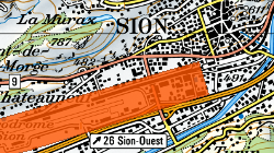
Aéroport de Sion: zone obstacles inférieurs à 25m
Zone où tout projet doit être soumis au SDM en raison de la proximité de l'aéroport
Simple
- Alternate title
-
obstacles aéroport de Sion
- Date (Creation)
- 2022-03-31
- Identifier
- 554
- Purpose
-
Identifier les obstacles pouvant géner l'approche des aéronefs
- Status
- Completed
Custodian
- Spatial representation type
- Vector
Spatial resolution
Equivalent scale
- Denominator
- 40000
- Topic category
-
- P Transportation
- O Structure
Extent
Extent
- Description
-
Canton of Valais (VS)
))

- Maintenance and update frequency
- Not planned
Resource format
- Title
-
ESRI Enterprise Geodatabase
- Date
- GEMET
-
-
administration
-
- GEMET
-
-
building
-
- GEMET
-
-
transport
-
- GEMET - INSPIRE themes, version 1.0
-
-
Elevation
-
- GEMET - INSPIRE themes, version 1.0
-
-
Buildings
-
- GEMET - INSPIRE themes, version 1.0
-
-
Area management/restriction/regulation zones and reporting units
-
- GEMET
-
-
airport
-
- geocat.ch
-
-
geodata
-
Resource constraints
- Use limitation
-
Accès réservé au SDM et au SeCC (e-Construction)
Resource constraints
- Access constraints
- Other restrictions
- Other constraints
- Non-publicly accessible basic geodata : level C (GeoIV, art. 21).
- Other constraints
-
Les conditions générales d'utilisation des géodonnées du Canton du Valais font foi ( https://www.vs.ch/fr/web/guest/information-legale).
- Language
- Français
- Character encoding
- UTF8
- Environment description
-
S:\Géodonnées VS\P Transport\Aéroport de Sion - zone obstacles inférieurs à 25m.lyr
- Basic Geodata
- true
- Basic Geodata ID
-
106.1, 201.1
- Basic Geodata Legal Level
- Federal
- Distribution format
-
-
ESRI Shapefile (SHP)
-
Distributor
- Hierarchy level
- Dataset
- Geometric object type
- Complex
- Geometric object count
- 1
- Reference system identifier
- EPSG:2056/CH1903+_MN95
Metadata
- Metadata identifier
- 906f67b7-c0aa-4f43-ad35-f48f78b7ee0a
- Language
- Français
- Character encoding
- UTF8
- Language
- Deutsch
- Character encoding
- UTF8
- Language
- Italiano
- Character encoding
- UTF8
- Language
- English
- Character encoding
- UTF8
- Language
- Rumantsch
- Character encoding
- UTF8
Distributor
Type of resource
- Resource scope
- Dataset
- Metadata linkage
-
https://www.geocat.ch/geonetwork/srv/api/records/906f67b7-c0aa-4f43-ad35-f48f78b7ee0a
- Date info (Creation)
- 2022-06-10T08:44:09Z
- Date info (Revision)
- 2026-05-11T14:52:30.669992Z
Metadata standard
- Title
-
eCH-0271