geocat.ch
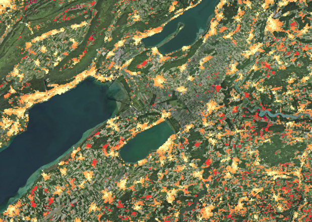
Service to the population: accessibility of restaurants
Measuring the distance to services for each inhabited hectare in Switzerland provides a wide range of statistical information on access to goods, services and recreation areas.
Sufficient access to basic goods and services needed in everyday life, as well as access to places of retreat such as lakeshores or forests, are of great importance for the quality of life. The calculation of accessibility to these services is a method to measure this phenomenon. Accessibility is operationalised by the distance travelled on the road network between the place of residence and the location of the nearest service provider or the nearest recreation area. The places of residence are not considered individually, but are aggregated by inhabited hectares.
Simple
- Alternate title
-
Accessibility of restaurants
- Date (Publication)
- 2021-06-15
- Identifier
- ch.bfs.erreichbarkeit-restaurants
- Status
- On going
Point of contact
Spatial resolution
- Spatial resolution
- 100 m
- Topic category
-
- M Society
Extent
Extent
- Description
-
Switzerland
))

- Maintenance and update frequency
- Irregular
- Duration of Conservation
- 100
- Appraisal of Archival Value
- N
Resource format
- Title
-
GeoTIFF (GEOTIFF)
- Date
Resource format
- Title
-
TEXT, semicolon separated (CSV)
- Date
Resource format
- Title
-
OGC Geopackage (GPKG)
- Date
- Keywords
-
-
Erreichbarkeit
-
Dienstleistung
-
- geocat.ch
-
-
company
-
road network
-
confederation
-
opendata.swiss
-
FSDI Federal Spatial Data Infrastructure
-
Resource specific usage
- Specific usage
-
Kommerzielle Verwendung nur mit separater Vereinbarung
Resource constraints
- Use constraints
- Other restrictions
- Language
- Deutsch
- Character encoding
- UTF8
- Basic Geodata
- false
- Basic Geodata Legal Level
- Federal
- Distribution format
-
-
Text (.csv), semicolon sepatated
-
ESRI Shapefile (SHP)
-
GeoTIFF (GEOTIFF)
-
OGC Geopackage (GPKG)
-
Digital transfer options
- OnLine resource
-
Vorschau map.geo.admin.ch
Preview map.geo.admin.ch
Digital transfer options
- OnLine resource
-
ch.bfs.erreichbarkeit-restaurants
WMS-FSDI service, layer "Accessibility of restaurants"
Digital transfer options
- OnLine resource
-
ch.bfs.erreichbarkeit-restaurants
WMTS-FSDI service, layer "Accessibility of restaurants"
Digital transfer options
- OnLine resource
-
-- zusätzliche Infos z.B. Amts Webseite, "-" in URL und Beschreibung einfügen, falls nicht vorhanden --
Digital transfer options
- OnLine resource
-
Geodata (CSV, GeoPackage, GeoTIFF)
Digital transfer options
- OnLine resource
-
Datenbeschreibung
Digital transfer options
- OnLine resource
-
GEOSTAT
GEOSTAT est le centre de compétence pour la géoinformation et le traitement numérique des images digitales de l'OFS.
Digital transfer options
- OnLine resource
-
Variablenliste
Digital transfer options
- OnLine resource
-
-- z. B. Link zu Fachportal, "-" in URL und Beschreibung einfügen falls nicht vorhanden --
- Geometric object type
- Point
- Reference system identifier
- EPSG:2056
Metadata
- Metadata identifier
- 8f48d5dd-270b-46c5-bf82-c8e7929d08f6
- Language
- Deutsch
- Character encoding
- UTF8
- Language
- Français
- Character encoding
- UTF8
- Language
- Italiano
- Character encoding
- UTF8
- Language
- English
- Character encoding
- UTF8
- Language
- Rumantsch
- Character encoding
- UTF8
Custodian
Type of resource
- Resource scope
- Dataset
- Metadata linkage
-
https://www.geocat.ch/geonetwork/srv/api/records/8f48d5dd-270b-46c5-bf82-c8e7929d08f6
- Date info (Creation)
- 2021-05-18T14:56:32Z
- Date info (Revision)
- 2026-06-15T08:26:29.984412Z
Metadata standard
- Title
-
eCH-0271