geocat.ch
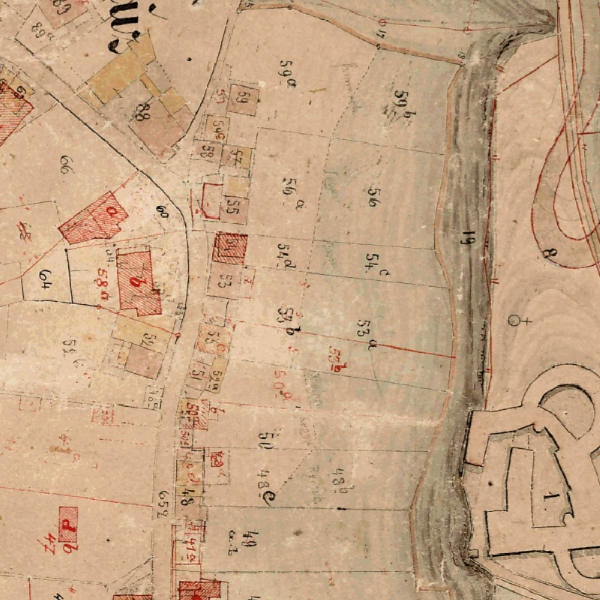
Historic cadastre maps of Liechtenstein 1:2,000 (circa 1876)
The old cadastre, created at a scale of 1:2000, was established between 1865 and 1871. The survey carried out by Peter Rheinberger and Alois Schauer primarily served to implement the new tax law of 1865.
Simple
- Date (Creation)
- 1876-01-01
- Identifier
- https://metadata.geo.llv.li/89510014-9404-4904-97c1-50772ae59a73
- Purpose
-
Historical map, historical development
- Status
- Obsolete
Publisher
- Hours of service
-
8:00-11:30 und 13:30-17:00
- Spatial representation type
- Grid
Spatial resolution
- Spatial resolution
- 0.5 m
- Topic category
-
- A Imagery base maps earth cover
Extent
Extent
- Description
-
Liechtenstein
))

- Maintenance and update frequency
- Unknown
- geocat.ch
-
-
national map
-
historic map
-
OpenData
-
- GEMET
-
-
Infrastructure for spatial information in Europe
-
historical evolution
-
- GEMET - INSPIRE themes, version 1.0
-
-
Land cover
-
- Räumlicher Anwendungsbereich
-
-
National
-
- geocat.ch
-
-
topography
-
- GEMET
-
-
map chart
-
Resource constraints
- Use limitation
-
No Conditions Apply
- Access constraints
- Other restrictions
- Use constraints
- Other restrictions
- Other constraints
- No limitations to public access
Resource constraints
- Access constraints
- Other restrictions
- Use constraints
- Other restrictions
- Other constraints
- No conditions to access and use
- Other constraints
- Opendata BY: Open use. Must provide the source.
- Language
- Deutsch
- Character encoding
- UTF8
- Subtopic Category
- A1 Base Maps, Landscape Models
- Attribute description
- RGB-Farbwert
- Distribution format
-
-
Tagged Image File Format (TIFF)
-
Point of contact
- Hours of service
-
8:00-11:30 und 13:30-17:00
Digital transfer options
Digital transfer options
- Units of distribution
-
1 Kartenblatt
- Transfer size
- 70
- OnLine resource
-
Historisches Lexikon des Fürstentum Liechtenstein
Artikel zur Geschichte der Vermessung in Liechtenstein
- Hierarchy level
- Dataset
Report
Result
- Title
-
VERORDNUNG (EG) Nr. 1089/2010 DER KOMMISSION vom 23. November 2010 zur Durchführung der Richtlinie 2007/2/EG des Europäischen Parlaments und des Rates hinsichtlich der Interoperabilität von Geodatensätzen und -diensten
- Date (Creation)
- 2010-08-18
- Explanation
-
nicht geprüft
- Pass
- false
- Statement
-
Auswertung aus photogrammetrischer Befliegung
- Hierarchy level
- Dataset
- Number of dimensions
- 2
- Cell geometry
- Area
- Transformation parameter availability
- 1
- Reference system identifier
- http://www.opengis.net/def/crs/EPSG/0/2056
- Maintenance and update frequency
- As needed
Metadata
- Metadata identifier
- 89510014-9404-4904-97c1-50772ae59a73
- Language
- Deutsch
- Character encoding
- UTF8
- Language
- Français
- Character encoding
- UTF8
- Language
- Italiano
- Character encoding
- UTF8
- Language
- English
- Character encoding
- UTF8
Point of contact
- Hours of service
-
8:00-11:30 und 13:30-17:00
Type of resource
- Resource scope
- Dataset
- Metadata linkage
-
https://www.geocat.ch/geonetwork/srv/api/records/89510014-9404-4904-97c1-50772ae59a73
- Date info (Creation)
- 2025-10-20T13:24:24.126Z
- Date info (Revision)
- 2026-04-13T09:32:39.795004Z
Metadata standard
- Title
-
eCH-0271