 geocat.ch
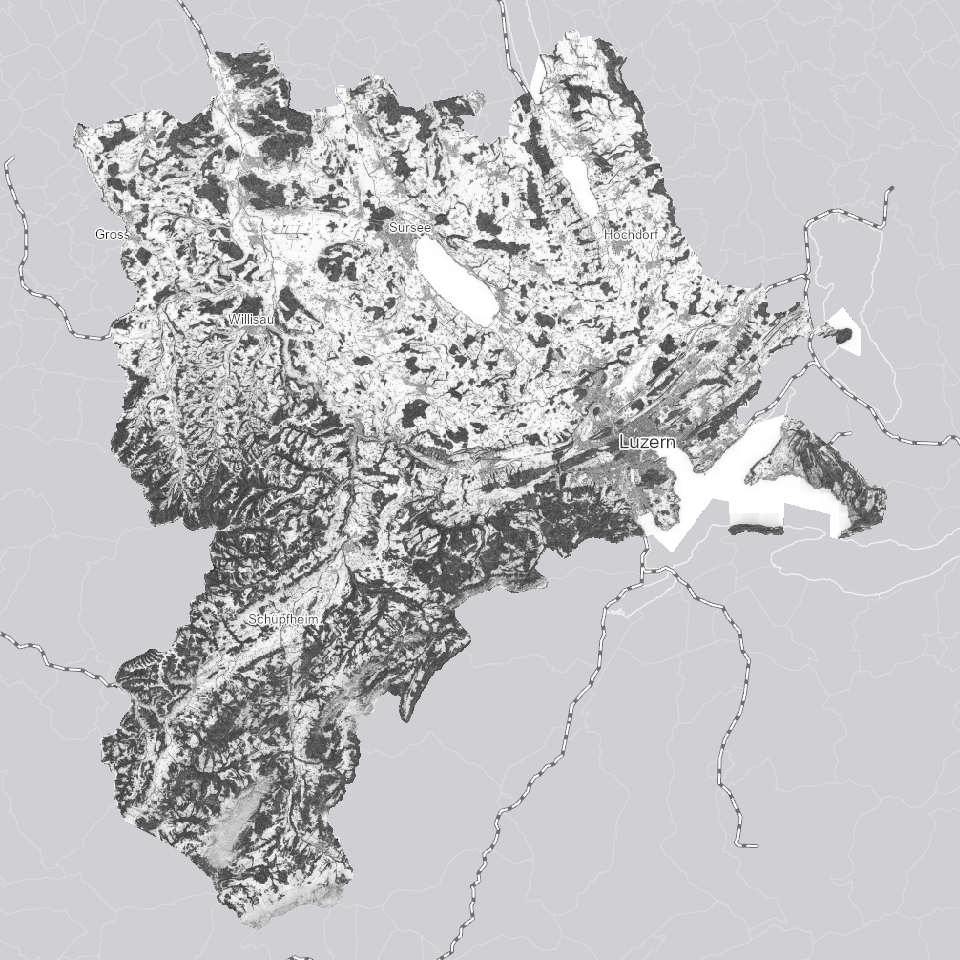
Digitales Oberflächenmodell (DOM) 2024: schattiertes Relief, 0.25m-Raster
Reliefdarstellung des Oberflächenmodells 2024 (0.25x0.25m Raster) basierend auf Lichtsimulation mittels ray-tracing
Simple
- Alternate title
-
DOM24ROC_DS
- Date (Creation)
- 2025-10-01
- Presentation form
- Digital map
- Purpose
-
Diese spezielle Reliefdarstellung zeigt wie Lichtstrahlen durch umliegende Objekte oder Geländeformen blockiert oder reflektiert werden. Die Verdeckung (Okklusion) wird durch ray-tracing berechnet und simuliert das Verhalten von Lichtstrahlen. Es wurde das direkte und indirekte Licht (einfache Reflexion) berücksichtigt. Dies führt zu einer realistischeren Darstellung von Licht- und Schattenverhältnissen. Es entsteht ein besserer räumlicher Eindruck der relativen Höhenunterschiede. Der Verwendungszweck liegt hauptsächlich in der Visualisierung in Karten.
- Status
- Completed
Publisher
Owner
- Spatial representation type
- Grid
- Topic category
-
- C Elevation
Extent
Extent
- Description
-
Kanton Luzern
))
- Maintenance and update frequency
- Not planned
- geocat.ch
-
-
opendata.swiss
-
Amtliche Vermessung/AV
-
Oberflächenmodell
-
Referenzsystem
-
Topographie
-
Resource constraints
- Access constraints
- none
- Use constraints
- Copyright
Resource constraints
- Use limitation
-
öffentlich zugängliche Geobasisdaten
Resource constraints
- Access constraints
- none
- Use constraints
- none
Resource constraints
- Use limitation
-
Freie Nutzung. Quellenangabe ist Pflicht
- Distribution format
-
-
Tagged Image File Format (.tif)
-
Point of contact
Digital transfer options
- OnLine resource
-
Datenshop
Produktansicht Geodatenshop
- Statement
-
unbekannt
- Reference system identifier
- EPSG:2056
- Maintenance and update frequency
- Not planned
Metadata
- Metadata identifier
- 86d77ab9-97a0-4491-8929-7ab910073b52
- Language
- Deutsch
- Character encoding
- UTF-8
Point of contact
Type of resource
- Resource scope
- Dataset
- Metadata linkage
-
https://www.geocat.ch/geonetwork/srv/api/records/86d77ab9-97a0-4491-8929-7ab910073b52
- Date info (Creation)
- 2025-01-10
- Date info (Revision)
- 2026-06-19T03:20:05.093496Z
Metadata standard
- Title
-
ISO19115.3-2018.che
)))