geocat.ch
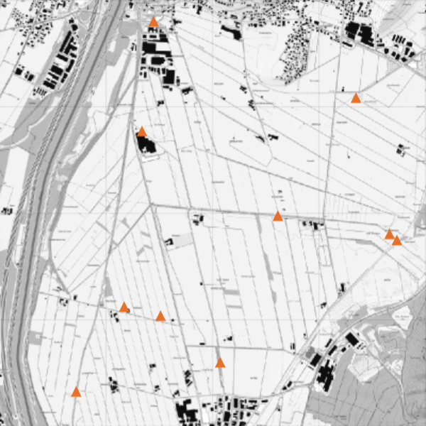
Surface water biology monitoring stations
Surface water biology monitoring stations in the Principality of Liechtenstein. Further information is provided by the Office of Environment.
Simple
- Date (Publication)
- 2024-01-01
- Identifier
- https://metadata.geo.llv.li/84487ef8-145d-485a-9254-cf59b6e316b1
- Status
- On going
Owner
- Hours of service
-
8:00-11:30 und 13:30-17:00
Publisher
- Hours of service
-
8:00-11:30 und 13:30-17:00
- Spatial representation type
- Vector
Spatial resolution
Equivalent scale
- Denominator
- 5000
- Topic category
-
- G Biota
Extent
Extent
- Description
-
Liechtenstein
))

- Maintenance and update frequency
- As needed
- geocat.ch
-
-
water status
-
- GEMET - INSPIRE themes, version 1.0
-
-
Hydrography
-
- Räumlicher Anwendungsbereich
-
-
National
-
- GEMET
-
-
pollution
-
water
-
Resource constraints
- Access constraints
- Other restrictions
- Use constraints
- Other restrictions
- Other constraints
- No limitations to public access
- Language
- Deutsch
- Character encoding
- UTF8
- Distribution format
-
-
ESRI File Geodatabase FileGDB (GDB)
-
OGC Geopackage (GPKG)
-
Distributor
- Hours of service
-
8:00-11:30 und 13:30-17:00
Digital transfer options
- OnLine resource
-
Geodatenportal der Liechtensteinischen Landesverwaltung
Geodata portal of the Liechtenstein National Administration
- Hierarchy level
- Dataset
Report
Result
- Title
-
VERORDNUNG (EG) Nr. 1089/2010 DER KOMMISSION vom 23. November 2010 zur Durchführung der Richtlinie 2007/2/EG des Europäischen Parlaments und des Rates hinsichtlich der Interoperabilität von Geodatensätzen und -diensten
- Date (Publication)
- 2010-12-08
- Explanation
-
Gemäss INSPIRE Bestandteil des Themas "Bewirtschaftungsgebiete/Schutzgebiete/geregelte Gebiete und Berichterstattungseinheiten"
- Pass
- false
- Statement
-
Digitalisierung
- Hierarchy level
- Dataset
- Geometric object type
- Point
- Geometric object count
- 35
- Reference system identifier
- http://www.opengis.net/def/crs/EPSG/0/2056
- Reference system identifier
- http://www.opengis.net/def/crs/EPSG/0/4936
- Maintenance and update frequency
- As needed
Metadata
- Metadata identifier
- 84487ef8-145d-485a-9254-cf59b6e316b1
- Language
- Deutsch
- Character encoding
- UTF8
- Language
- Français
- Character encoding
- UTF8
- Language
- Italiano
- Character encoding
- UTF8
- Language
- English
- Character encoding
- UTF8
Point of contact
- Hours of service
-
8:00-11:30 und 13:30-17:00
Type of resource
- Resource scope
- Dataset
- Metadata linkage
-
https://www.geocat.ch/geonetwork/srv/api/records/84487ef8-145d-485a-9254-cf59b6e316b1
- Date info (Creation)
- 2025-11-21T09:36:17.274Z
- Date info (Revision)
- 2026-05-05T14:52:24.289105Z
Metadata standard
- Title
-
eCH-0271