geocat.ch
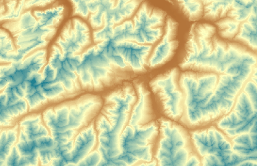
Das digitale Höhenmodell der Schweiz mit einer Maschenweite von 200 m
Le modéle numérique de terrain de la Suisse avec une maille de 200m
Il modello altitudinale della Svizzera con una maglia di 200m
The digital height model of Switzerland with a 200m grid
Das digitale Höhenmodell DHM25 / 200 ist ein Datensatz, welcher die dreidimensionale Form der Erdoberfläche beschreibt. Es handelt sich um eine Höhenmatrix mit einer Maschenweite von 200 m. Er wurde aus dem Matrixmodell DHM25, welches eine Maschenweite von 25m hat, abgeleitet. Das DHM25 / 200 gibt die Form der rohen Erdoberfläche ohne Bewuchs und Bebauung wieder. Seen werden mit der Seeoberfläche dargestellt. DHM25 / 200 kann gratis heruntergeladen werden.
Le modèle numérique du terrain MNT25 / 200 est un jeu de données qui décrit la surface terrestre en trois dimensions. Il se présente sous la forme d’une matrice d'altitude avec une maille de 200 m. Il a été obtenu par un rééchantillonage du modèle matricielle MNT25 qui a une maille de 25m. Le MNT25 / 200 fournit les formes brutes de la surface terrestre, sans végétation ni construction. es lacs sont représentés par l'altitude de leur surface. MNT25 / 200 peut être téléchargé gratuitement.
Il modello altimetrico MDT25 / 200m é un set di dati che descrive la superficie terrestre in tre dimensioni. Si tratta di una matrice altitudinale con una maglia di 200m. Il modello a matrice è stato sviluppato mediante un ridimensionamento del modello a matrice MDT25 che ha una maglia di 25 m.L’MDT25 / 200m presenta le forme grezze della superficie terreste, senza vegetazione né costruzioni.I laghi sono rappresentati dall’altitudine della loro superficie. MDT25 / 200 può essere scaricato gratuitamente.
The digital height model DHM25 / 200 is a data set representing the three-dimensional form of the earth's surface. It is a height matrix with a 200-m grid. It has been resampled from the DHM25 matrix model, which has a 25-m grid. he DHM25 represents the topography of the earth's surface without vegetation or built up areas. Lakes are represented by their surface. DHM25 / 200 can be freely downloaded.
Simple
-
Autre titreAltri nomi o acronimiAlternate titleAlternativtitel
-
DHM25 / 200
MNT25 / 200
MDT25 / 200
DHM25 / 200
-
Date (Publication)Data (Pubblicazione)Date (Publication)Datum (Publikation)
- 2010-01-01
-
IdentifiantIdentificatoreIdentifierKennung
- ch.swisstopo.digitales-hoehenmodell_25
-
ÉtatStatoStatusBearbeitungsstatus
-
TerminéCompletatoCompletedAbgeschlossen
Point de contact
Punto di contatto
Point of contact
Ansprechpartner
-
Type de représentation spatialeTipo di rappresentazione spazialeSpatial representation typeRäumliche Darstellungsart
-
grilleRasterGridRaster, Gitter
Résolution spatiale
Risoluzione spaziale
Spatial resolution
Räumliche Auflösung
-
Distance de résolutionDistanza di risoluzioneSpatial resolutionDistanz
- 200 m
-
Catégorie de thèmeCategoria ISOTopic categoryThematik
-
-
C ÉlévationC AltitudineC ElevationC Höhenangaben
-
Étendue
Estensione
Extent
Ausdehnung
Étendue
Estensione
Extent
Ausdehnung
-
DescriptionDescrizioneDescriptionBeschreibung
-
DHM25
DHM25
MNT25
MDT25
-
Identifiant géographiqueIdentificatore geograficoGeographic identifierGeografische Kennung
- DHM25DHM25MNT25MDT25
))

-
Fréquence de mise à jourFrequenza di aggiornamentoMaintenance and update frequencyWartungsintervall
-
Non planifiéeNon pianificatoNot plannedNicht geplant
-
Remarque sur la mise à jourNota sull'aggiornamentoMaintenance noteAnmerkung
-
Der Nachführungsstand der Elemente des Basismodells entspricht demjenigen der Ersterfassung, mit Ausnahme der Gletschergebiete, welche gemäss dem im Winter 2000/2001 verfügbaren Kartenstand nachgeführt sind.
L’état de mise à jour des éléments du modèle de base correspond à celui de la saisie initiale, exception faite des régions des glaciers qui ont été mises à jour sur la base des cartes disponibles en hiver 2000/⁄2001.
The status of the DHM25 corresponds to that of the initial capture and digitization of the elements for the basis model except for glacial regions, which were updated in winter 2000/2001.
- geocat.ch
-
-
géodonnées
geodati
geodata
-
isophyse
isofise
isophysis
-
SIG (Système d'Information Géographique)
SIG (Sistema Informativo Geografico)
GIS (Geographic Information System)
-
représentation du terrain
rappresentazione del terreno
terrain representation
-
courbe de niveau
curva di livello
contour line
-
MNA (modèle numérique d'altitude)
DEM (modello digitale di elevazione)
DEM (digital elevation model)
-
cote d'altitude
quota altimetrica
spot height
-
topographie
topografia
topography
-
modèle numérique de terrain MNT
modello digitale del terreno DTM
digital terrain model DTM
-
opendata.swiss
opendata.swiss
opendata.swiss
-
visualisation 3D
visualizzazione 3D
3D visualisation
-
ombrage
ombreggiatura
hillshade
-
- GEMET - INSPIRE themes, version 1.0
-
-
Altitude
Elevazione
Elevation
-
- GEMET
-
-
relief
rilievo
relief (land)
-
- geocat.ch
-
-
BGDI Bundesgeodaten-Infrastruktur
IFDG l’Infrastructure Fédérale de données géographiques
IFDG Infrastruttura federale dei dati geografici
FSDI Federal Spatial Data Infrastructure
-
Contraintes sur la ressource
Vincoli sulle risorse
Resource constraints
Ressourcenbeschränkungen
-
Autres contraintesAltri vincoliOther constraintsAndere Einschränkungen
-
Freie Nutzung. Quellenangabe ist Pflicht.
Utilisation libre. Obligation d’indiquer la source.
NonCommercialAllowed-CommercialAllowed-ReferenceRequired
Ressource associée
Risorsa associata
Associated resource
Verlinkte Ressource
-
Type d'associationTipo di associazioneAssociation TypeAssoziationstyp
-
Citation de travail plus largeCitazione di un'opera più ampiaReference to a master resource of which this one is a partÜbergeordneter Datenbestand
-
Metadata ReferenceRiferimento metadatiMetadata ReferenceMetadatenreferenz
-
LangueLinguaLanguageSprache
- Deutsch
-
Encodage de caractèresCodifica dei caratteriCharacter encodingZeichenkodierung
-
Utf8UTF8UTF8Utf8
-
Géodonnées de baseGeodati di baseBasic GeodataGeobasisdaten
- true
-
Identifiant Géodonnées de baseIdentificativo dei geodati di baseBasic Geodata IDIdentifikator des Geobasisdatensatzes
-
41.3
-
Niveau des géodonnées de baseLivello legale dei geodati di baseBasic Geodata Legal LevelGeobasisdatenebene
-
FédéralFederaleFederalNational
-
Format de distributionFormato (codifica)Distribution formatAbgabeformat
-
-
ESRI Arcinfo ASCII GRID (ASC)
-
GRID ASCII (XYZ)
-
AutoCAD DXF (DXF)
-
Options de transfert numérique
Opzioni di trasferimento digitale
Digital transfer options
Optionen für die digitale Übertragung
Options de transfert numérique
Opzioni di trasferimento digitale
Digital transfer options
Optionen für die digitale Übertragung
-
Ressource en ligneRisorsa onlineOnLine resourceOnline
-
Shop
Options de transfert numérique
Opzioni di trasferimento digitale
Digital transfer options
Optionen für die digitale Übertragung
-
Ressource en ligneRisorsa onlineOnLine resourceOnline
-
MNT25 / 200m
-
Généralités sur la provenanceInformazioni generali sulla provenienzaStatementErklärung
-
Interpolation aus der Höheninformation der Landeskarte 1:25'000 abgeleitet, der Landeskarte 1:50'000 im erweiterten Perimeter.
Interpolation basée sur les informations d'altitude de la Carte nationale 1:25'000 et de la Carte nationale 1:50'000 pour le périmètre élargi.
Interpolation based on the elevation information of the National map 1:25'000, of the National map 1:50'000 for the extended perimeter.
-
NiveauLivelloHierarchy levelBezugsebene
-
Jeu de donnéesSet di datiDatasetDatenbestand
-
Nom du système de référenceNome del sistema di riferimentoReference system identifierName des Referenzsystems
- EPSG:21781
-
Nom du système de référenceNome del sistema di riferimentoReference system identifierName des Referenzsystems
- EPSG:5728
Metadata
-
Identifiant des métadonnéesIdentificativo della schedaMetadata identifierIdentifikator des Metadatensatzes
- 7eeb5314-f988-4e70-be61-07bfafc10439
-
LangueLinguaLanguageSprache
- Deutsch
-
Encodage de caractèresCodifica dei caratteriCharacter encodingZeichenkodierung
-
Utf8UTF8UTF8Utf8
-
LangueLinguaLanguageSprache
- Français
-
Encodage de caractèresCodifica dei caratteriCharacter encodingZeichenkodierung
-
Utf8UTF8UTF8Utf8
-
LangueLinguaLanguageSprache
- Italiano
-
Encodage de caractèresCodifica dei caratteriCharacter encodingZeichenkodierung
-
Utf8UTF8UTF8Utf8
-
LangueLinguaLanguageSprache
- English
-
Encodage de caractèresCodifica dei caratteriCharacter encodingZeichenkodierung
-
Utf8UTF8UTF8Utf8
Point de contact
Punto di contatto
Point of contact
Ansprechpartner
-
Heures de serviceOrario di servizioHours of serviceBetriebszeiten
-
08h30 - 11h00 / 14h00 - 16h00 GMT+1
Type de ressource
Tipo di risorsa
Type of resource
Anwendungsbereich der Metadaten
-
Domaine d'application de la ressourceAmbito di applicazione della risorsaResource scopeDomäne der Ressourcenanwendung
-
Jeu de donnéesSet di datiDatasetDatenbestand
-
Informations de date (Création)Informazioni sulla data (Creazione)Date info (Creation)Datumsangaben (Erstellung)
- 2016-01-05T11:43:47Z
-
Informations de date (Révision)Informazioni sulla data (Revisione)Date info (Revision)Datumsangaben (Aktualisierung)
- 2026-04-13T09:16:29.067216Z
Norme des métadonnées
Standard dei metadati
Metadata standard
Metadatenstandard
-
TitreTitoloTitleTitel
-
eCH-0271